Artículos
2026 2025 2024 2023 2022 2021 2020 2019 2018 2017 2016 2015 2014 2013 2012 2011
Tesis: Doctorado Maestría
Otros
Tesis supervisadas
Artículos
2026
Automatic 3D building model generation for energy digital twins. Oscar Roman, Giorgio Agugiaro, Ken Arroyo Ohori, Maarten Bassier, Elisa Mariarosaria Farella y Fabio Remondino. En Songnian Li, Derek Lichti, Shabnam Jabari, Xinming Tang, Antonio Maria Garcia Tommaselli y Tao Zhang (eds.), XXV ISPRS Congress 2026 “From Imagery to Understanding”, Commission I, ISPRS Annals of the Photogrammetry, Remote Sensing and Spatial Information Sciences XI–1–2026, ISPRS, Toronto, Canada, julio 2026, pp. 447–454. ISSN: 2194–9042 (Print), 2194–9050 (Internet and USB).
@incollection{26isprs_oscar,
	address = {Toronto, Canada},
	author = {Oscar Roman and Giorgio Agugiaro and Ken {Arroyo Ohori} and Maarten Bassier and Elisa Mariarosaria Farella and Fabio Remondino},
	booktitle = {XXV ISPRS Congress 2026 ``From Imagery to Understanding'', Commission I},
	editor = {Songnian Li and Derek Lichti and Shabnam Jabari and Xinming Tang and Antonio Maria Garcia Tommaselli and Tao Zhang},
	month = {jul},
	note = {ISSN: 2194--9042 (Print), 2194--9050 (Internet and USB)},
	pages = {447--454},
	publisher = {ISPRS},
	series = {ISPRS Annals of the Photogrammetry, Remote Sensing and Spatial Information Sciences},
	title = {Automatic {3D} Building Model Generation for Energy Digital Twins },
	volume = {XI--1--2026},
	year = {2026}
}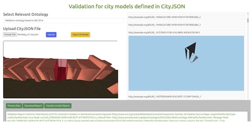
Leveraging knowledge graphs and semantic web technologies for validating 3D city models. Alper Tunga Akın, Ziya Usta, Jantien Stoter, Ken Arroyo Ohori y Çetin Cömert. International Journal of Geographical Information Science 40(6), junio 2026, pp. 1867–1893.
@article{26ijgis,
	author = {Alper Tunga Ak\in and Ziya Usta and Jantien Stoter and Ken {Arroyo Ohori} and \c{C}etin C\"omert},
	journal = {International Journal of Geographical Information Science},
	month = {jun},
	number = {6},
	pages = {1867--1893},
	title = {Leveraging knowledge graphs and semantic web technologies for validating {3D} city models},
	volume = {40},
	year = {2026}
}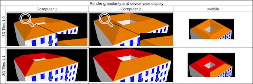
Visualization of urban digital twins on the web with attribute-driven adaptive tiling. Ziya Usta, Alper Tunga Akın, Ken Arroyo Ohori y Jantien Stoter. Environmental Modelling & Software 197, febrero 2026.
@article{26envsoft,
	author = {Ziya Usta and Alper Tunga Ak\in and Ken {Arroyo Ohori} and Jantien Stoter},
	journal = {Environmental Modelling \& Software},
	month = {feb},
	title = {Visualization of Urban Digital Twins on the web with attribute-driven adaptive tiling},
	volume = {197},
	year = {2026}
}
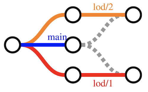
Defining LoDs to support BIM-based 3D building abstractions in GIS. Jasper van der Vaart, Ken Arroyo Ohori, Jantien Stoter y Siham El Yamani. En Fabiola Yepez, Sisi Zlatanova, Dariela Vázquez-Rodríguez y Andrea Escobedo-Támez (eds.), Conference on Geoinformation 2025, International Archives of the Photogrammetry, Remote Sensing and Spatial Information Sciences XLVIII–3(W4–2025), ISPRS, Mérida, Mexico, enero 2026, pp. 55–62. ISSN: 2194–9034 (Internet and USB), 1682–1750 (Print), 1682–1777 (CD-ROM).
@incollection{26selper_jasper,
	address = {M\'erida, Mexico},
	author = {Jasper van der Vaart and Ken {Arroyo Ohori} and Jantien Stoter and Siham El Yamani},
	booktitle = {Conference on Geoinformation 2025},
	editor = {Fabiola Yepez and Sisi Zlatanova and Dariela V\'azquez-Rodr\'iguez and Andrea Escobedo-T\'amez},
	month = {jan},
	note = {ISSN: 2194--9034 (Internet and USB), 1682--1750 (Print), 1682--1777 (CD-ROM)},
	number = {W4--2025},
	pages = {55--62},
	publisher = {ISPRS},
	series = {International Archives of the Photogrammetry, Remote Sensing and Spatial Information Sciences},
	title = {Defining {LoDs} to support {BIM}-based {3D} building abstractions in {GIS}},
	volume = {XLVIII--3},
	year = {2026}
}
Creating 3D city models of Mexican cities based on open data. Ken Arroyo Ohori y Jantien Stoter. En Fabiola Yepez, Sisi Zlatanova, Dariela Vázquez-Rodríguez y Andrea Escobedo-Támez (eds.), Conference on Geoinformation 2025, International Archives of the Photogrammetry, Remote Sensing and Spatial Information Sciences XLVIII–3(W4–2025), ISPRS, Mérida, Mexico, enero 2026, pp. 3–9. ISSN: 2194–9034 (Internet and USB), 1682–1750 (Print), 1682–1777 (CD-ROM).
@incollection{26selper_cdmx,
	address = {M\'erida, Mexico},
	author = {Ken {Arroyo Ohori} and Jantien Stoter},
	booktitle = {Conference on Geoinformation 2025},
	editor = {Fabiola Yepez and Sisi Zlatanova and Dariela V\'azquez-Rodr\'iguez and Andrea Escobedo-T\'amez},
	month = {jan},
	note = {ISSN: 2194--9034 (Internet and USB), 1682--1750 (Print), 1682--1777 (CD-ROM)},
	number = {W4--2025},
	pages = {3--9},
	publisher = {ISPRS},
	series = {International Archives of the Photogrammetry, Remote Sensing and Spatial Information Sciences},
	title = {Creating {3D} city models of {M}exican cities based on open data},
	volume = {XLVIII--3},
	year = {2026}
}
2025

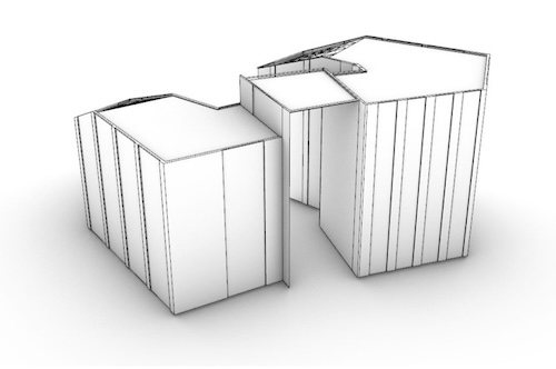
A methodology to convert highly detailed BIM models into 3D geospatial building models at different LoDs. Jasper van der Vaart, Ken Arroyo Ohori y Jantien Stoter. ISPRS International Journal of Geo-Information 14(2), noviembre 2025. ISSN: 2220–9964.
@article{25ijgi,
	author = {Jasper van der Vaart and Ken {Arroyo Ohori} and Jantien Stoter},
	journal = {ISPRS International Journal of Geo-Information},
	month = {nov},
	note = {ISSN: 2220--9964},
	number = {2},
	title = {A Methodology to Convert Highly Detailed {BIM} Models into {3D} Geospatial Building Models at Different {LoDs}},
	volume = {14},
	year = {2025}
}
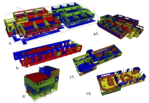
Scan-to-EDTs: automated generation of energy digital twins from 3D point clouds. Oscar Roman, Maarten Bassier, Giorgio Agugiaro, Ken Arroyo Ohori, Elisa Mariarosaria Farella y Fabio Remondino. Buildings 15(22), noviembre 2025.
@article{25buildings,
	author = {Oscar Roman and Maarten Bassier and Giorgio Agugiaro and Ken {Arroyo Ohori} and Elisa Mariarosaria Farella and Fabio Remondino},
	journal = {Buildings},
	month = {nov},
	number = {22},
	title = {Scan-to-{EDT}s: Automated Generation of Energy Digital Twins from {3D} Point Clouds},
	volume = {15},
	year = {2025}
}
2024

Geometry level of information needs for digital building permit regulations. S. El Yamani, J. Stoter, F. Noardo, A. Hakim, K. Arroyo Ohori y J. van der Vaart. En Francesca Noardo y Judith Fauth (eds.), Digital Building Permit Conference 2024, EUnet4DBP, Barcelona, Spain, julio 2024, pp. 112–121.
@incollection{24eunet4dbp,
	address = {Barcelona, Spain},
	author = {El Yamani, S. and Stoter, J. and Noardo, F. and Hakim, A. and Arroyo Ohori, K. and van der Vaart, J.},
	booktitle = {Digital Building Permit Conference 2024},
	editor = {Francesca Noardo and Judith Fauth},
	month = {jul},
	pages = {112--121},
	publisher = {EUnet4DBP},
	title = {Geometry level of information needs for digital building permit regulations},
	year = {2024}
}
Towards extending CityGML for property valuation: property valuation ADE. Siham El Yamani, Rafika Hajji, Roland Billen, Ken Arroyo Ohori, Jasper van der Vaart, Amir Hakim y Jantien Stoter. En Lucía Díaz-Vilariño y Jesús Balado (eds.), 19th 3D GeoInfo Conference 2024, ISPRS Annals of the Photogrammetry, Remote Sensing and Spatial Information Sciences X–4(W5–2024), ISPRS, Vigo, Spain, junio 2024, pp. 127–135. ISSN: 2194–9042 (Print), 2194–9050 (Internet and USB).
@incollection{243dgeoinfo_siham,
	address = {Vigo, Spain},
	author = {Siham El Yamani and Rafika Hajji and Roland Billen and Ken Arroyo Ohori and Jasper van der Vaart and Amir Hakim and Jantien Stoter},
	booktitle = {19th 3D GeoInfo Conference 2024},
	editor = {Luc\'ia D\'iaz-Vilari\~no and Jes\'us Balado},
	month = {jun},
	note = {ISSN: 2194--9042 (Print), 2194--9050 (Internet and USB)},
	number = {W5--2024},
	pages = {127--135},
	publisher = {ISPRS},
	series = {ISPRS Annals of the Photogrammetry, Remote Sensing and Spatial Information Sciences},
	title = {Towards Extending {CityGML} for Property Valuation: Property Valuation {ADE}},
	volume = {X--4},
	year = {2024}
}
Enriching lower LoD 3D city models with semantic data computed by the voxelisation of BIM sources. Jasper van der Vaart, Jantien Stoter, Giorgio Agugiaro, Ken Arroyo Ohori, Amir Hakim y Siham El Yamani. En Lucía Díaz-Vilariño y Jesús Balado (eds.), 19th 3D GeoInfo Conference 2024, ISPRS Annals of the Photogrammetry, Remote Sensing and Spatial Information Sciences X–4(W5–2024), ISPRS, Vigo, Spain, junio 2024, pp. 297–308. ISSN: 2194–9042 (Print), 2194–9050 (Internet and USB).
@incollection{243dgeoinfo_jasper,
	address = {Vigo, Spain},
	author = {Jasper van der Vaart and Jantien Stoter and Giorgio Agugiaro and Ken Arroyo Ohori and Amir Hakim and Siham El Yamani},
	booktitle = {19th 3D GeoInfo Conference 2024},
	editor = {Luc\'ia D\'iaz-Vilari\~no and Jes\'us Balado},
	month = {jun},
	note = {ISSN: 2194--9042 (Print), 2194--9050 (Internet and USB)},
	number = {W5--2024},
	pages = {297--308},
	publisher = {ISPRS},
	series = {ISPRS Annals of the Photogrammetry, Remote Sensing and Spatial Information Sciences},
	title = {Enriching lower {LoD} {3D} city models with semantic data computed by the voxelisation of {BIM} sources},
	volume = {X--4},
	year = {2024}
}
Enhancing georeferencing of IFC models through surveyed points integration. Amir Hakim, Ken Arroyo Ohori, Jasper van der Vaart, Siham El Yamani y Jantien Stoter. En Lucía Díaz-Vilariño y Jesús Balado (eds.), 19th 3D GeoInfo Conference, International Archives of the Photogrammetry, Remote Sensing and Spatial Information Sciences XLVIII–4(W11–2024), ISPRS, Vigo, Spain, junio 2024, pp. 41–47. ISSN: 2194–9034 (Internet and USB), 1682–1750 (Print), 1682–1777 (CD-ROM).
@incollection{243dgeoinfo_amir,
	address = {Vigo, Spain},
	author = {Amir Hakim and Ken Arroyo Ohori and Jasper van der Vaart and Siham El Yamani and Jantien Stoter},
	booktitle = {19th 3D GeoInfo Conference},
	editor = {Luc\'ia D\'iaz-Vilari\~no and Jes\'us Balado},
	month = {jun},
	note = {ISSN: 2194--9034 (Internet and USB), 1682--1750 (Print), 1682--1777 (CD-ROM)},
	number = {W11--2024},
	pages = {41--47},
	publisher = {ISPRS},
	series = {International Archives of the Photogrammetry, Remote Sensing and Spatial Information Sciences},
	title = {Enhancing Georeferencing of {IFC} Models through Surveyed Points Integration},
	volume = {XLVIII--4},
	year = {2024}
}
Development of a Geo to BIM converter: CityJSON importer plugin for Autodesk Revit. Amir Hakim, Jasper van der Vaart, Ken Arroyo Ohori y Jantien Stoter. En Thomas H. Kolbe, Andreas Donaubauer y Christof Beil (eds.), Recent Advances in 3D Geoinformation Science: Proceedings of the 18th 3D GeoInfo Conference, Lecture Notes in Geoinformation and Cartography, Springer Cham, Munich, Germany, febrero 2024, pp. 249–263. ISBN: 978–3–031–43699–4 (eBook), 978–3–031–43698–7 (Hardcover), 978–3–031–43701–4 (Softcover), ISSN: 1863–2246, eISSN: 1863–2351.
@incollection{243dgeoinfo_revitplugin,
	address = {Munich, Germany},
	author = {Amir Hakim and Jasper van der Vaart and Ken Arroyo Ohori and Jantien Stoter},
	booktitle = {Recent Advances in 3D Geoinformation Science: Proceedings of the 18th 3D GeoInfo Conference},
	editor = {Thomas H. Kolbe and Andreas Donaubauer and Christof Beil},
	month = {feb},
	note = {ISBN: 978--3--031--43699--4 (eBook), 978--3--031--43698--7 (Hardcover), 978--3--031--43701--4 (Softcover), ISSN: 1863--2246, eISSN: 1863--2351},
	pages = {249--263},
	publisher = {Springer Cham},
	series = {Lecture Notes in Geoinformation and Cartography},
	title = {Development of a {Geo} to {BIM} Converter: {CityJSON} Importer Plugin for {Autodesk} {Revit}},
	year = {2024}
}
Assessment of the LoD specification for the integration of BIM-derived building models in 3D city models. Jasper van der Vaart, Jantien Stoter, Abdoulaye Diakité, Filip Biljecki, Ken Arroyo Ohori y Amir Hakim. En Thomas H. Kolbe, Andreas Donaubauer y Christof Beil (eds.), Recent Advances in 3D Geoinformation Science: Proceedings of the 18th 3D GeoInfo Conference, Lecture Notes in Geoinformation and Cartography, Springer Cham, Munich, Germany, febrero 2024, pp. 171–191. ISBN: 978–3–031–43699–4 (eBook), 978–3–031–43698–7 (Hardcover), 978–3–031–43701–4 (Softcover), ISSN: 1863–2246, eISSN: 1863–2351.
@incollection{243dgeoinfo_lodbim,
	address = {Munich, Germany},
	author = {Jasper van der Vaart and Jantien Stoter and Abdoulaye Diakit\'e and Filip Biljecki and Ken Arroyo Ohori and Amir Hakim},
	booktitle = {Recent Advances in 3D Geoinformation Science: Proceedings of the 18th 3D GeoInfo Conference},
	editor = {Thomas H. Kolbe and Andreas Donaubauer and Christof Beil},
	month = {feb},
	note = {ISBN: 978--3--031--43699--4 (eBook), 978--3--031--43698--7 (Hardcover), 978--3--031--43701--4 (Softcover), ISSN: 1863--2246, eISSN: 1863--2351},
	pages = {171--191},
	publisher = {Springer Cham},
	series = {Lecture Notes in Geoinformation and Cartography},
	title = {Assessment of the {LoD} Specification for the Integration of {BIM}-Derived Building Models in {3D} City Models},
	year = {2024}
}
Representations of 3D and 4D city models. Ken Arroyo Ohori, Hugo Ledoux, Jantien Stoter, Anna Labetski, Stelios Vitalis y Kavisha Kumar. En Sultan Kocaman, Devrim Akca, Daniela Poli y Fabio Remondino (eds.), 3D/4D City Modelling - From Sensors to Applications, capítulo 6, Whittles Publishing, 2024. ISBN: 978–1–8499–5475–4, Electronic ISBN: 978–1–5231–5811–9.
@incollection{244dmodelling,
	author = {Ken Arroyo Ohori and Hugo Ledoux and Jantien Stoter and Anna Labetski and Stelios Vitalis and Kavisha Kumar},
	booktitle = {3D/4D City Modelling - From Sensors to Applications},
	chapter = {6},
	editor = {Kocaman, Sultan and Akca, Devrim and Poli, Daniela and Remondino, Fabio},
	note = {ISBN: 978--1--8499--5475--4, Electronic ISBN: 978--1--5231--5811--9},
	publisher = {Whittles Publishing},
	title = {Representations of {3D} and {4D} city models},
	year = {2024}
}
2023
3D building metrics for urban morphology. Anna Labetski, Stelios Vitalis, Filip Biljecki, Ken Arroyo Ohori y Jantien Stoter. International Journal of Geographical Information Science 37(1), enero 2023, pp. 36–67.
@article{23ijgis,
	author = {Anna Labetski and Stelios Vitalis and Filip Biljecki and Ken {Arroyo Ohori} and Jantien Stoter},
	journal = {International Journal of Geographical Information Science},
	month = {jan},
	number = {1},
	pages = {36--67},
	title = {{3D} building metrics for urban morphology},
	volume = {37},
	year = {2023}
}
2022
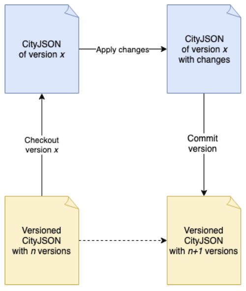
Applying versioning to 3D city models. Stelios Vitalis, Ken Arroyo Ohori y Jantien Stoter. En M. Aleksandrov, J. Barton y S. Zlatanova (eds.), 17th 3D GeoInfo Conference, International Archives of the Photogrammetry, Remote Sensing and Spatial Information Sciences XLVIII–4(W4–2022), ISPRS, Sydney, Australia, octubre 2022, pp. 177–182. ISSN: 2194–9034 (Internet and USB), 1682–1750 (Print), 1682–1777 (CD-ROM).
@incollection{223dgeoinfo_versioning,
	address = {Sydney, Australia},
	author = {Stelios Vitalis and Ken {Arroyo Ohori} and Jantien Stoter},
	booktitle = {17th 3D GeoInfo Conference},
	editor = {M. Aleksandrov and J. Barton and S. Zlatanova},
	month = {oct},
	note = {ISSN: 2194--9034 (Internet and USB), 1682--1750 (Print), 1682--1777 (CD-ROM)},
	number = {W4--2022},
	pages = {177--182},
	publisher = {ISPRS},
	series = {International Archives of the Photogrammetry, Remote Sensing and Spatial Information Sciences},
	title = {Applying versioning to {3D} city models},
	volume = {XLVIII--4},
	year = {2022}
}
Development and testing of the CityJSON energy extension for space heating demand calculation. Özge Tufan, Ken Arroyo Ohori, Camilo León-Sánchez, Giorgio Agugiaro y Jantien Stoter. En M. Aleksandrov, J. Barton y S. Zlatanova (eds.), 17th 3D GeoInfo Conference, International Archives of the Photogrammetry, Remote Sensing and Spatial Information Sciences XLVIII–4(W4–2022), ISPRS, Sydney, Australia, septiembre 2022, pp. 169–176. ISSN: 2194–9034 (Internet and USB), 1682–1750 (Print), 1682–1777 (CD-ROM).
@incollection{223dgeoinfo_ozge,
	address = {Sydney, Australia},
	author = {\"Ozge Tufan and Ken {Arroyo Ohori} and Camilo Le\'on-S\'anchez and Giorgio Agugiaro and Jantien Stoter},
	booktitle = {17th 3D GeoInfo Conference},
	editor = {M. Aleksandrov and J. Barton and S. Zlatanova},
	month = {sep},
	note = {ISSN: 2194--9034 (Internet and USB), 1682--1750 (Print), 1682--1777 (CD-ROM)},
	number = {W4--2022},
	pages = {169--176},
	publisher = {ISPRS},
	series = {International Archives of the Photogrammetry, Remote Sensing and Spatial Information Sciences},
	title = {Development and Testing of the {CityJSON} energy extension for space heating demand calculation},
	volume = {XLVIII--4},
	year = {2022}
}
Extracting coastal water depths from multi-temporal sentinel-2 images using convolutional neural networks. Yustisi Lumban-Gaol, Ken Arroyo Ohori y Ravi Peters. Marine Geodesy 45(6), julio 2022, pp. 615–644.
@article{22umgd,
	author = {Yustisi Lumban-Gaol and Ken {Arroyo Ohori} and Ravi Peters},
	journal = {Marine Geodesy},
	month = {jul},
	number = {6},
	pages = {615--644},
	title = {Extracting Coastal Water Depths from Multi-Temporal Sentinel-2 Images Using Convolutional Neural Networks},
	volume = {45},
	year = {2022}
}
GeoBIM information to check digital building permit regulations. Nadine Hobeika, Jordi van Liempt, Francesca Noardo, Ken Arroyo Ohori y Jantien Stoter. En Sisi Zlatanova, George Sithole y Jack Barton (eds.), Congress “Imaging today, foreseeing tomorrow”, Commission IV, International Archives of the Photogrammetry, Remote Sensing and Spatial Information Sciences XLIII–B4–2022, ISPRS, junio 2022, pp. 529–535. ISSN: 2194–9034 (Internet and USB), 1682–1750 (Print), 1682–1777 (CD-ROM).
@incollection{22isprs,
	author = {Nadine Hobeika and Jordi van Liempt and Francesca Noardo and Ken {Arroyo Ohori} and Jantien Stoter},
	booktitle = {Congress ``Imaging today, foreseeing tomorrow'', Commission IV},
	editor = {Sisi Zlatanova and George Sithole and Jack Barton},
	month = {jun},
	note = {ISSN: 2194--9034 (Internet and USB), 1682--1750 (Print), 1682--1777 (CD-ROM)},
	pages = {529--535},
	publisher = {ISPRS},
	series = {International Archives of the Photogrammetry, Remote Sensing and Spatial Information Sciences},
	title = {{GeoBIM} information to check digital building permit regulations},
	volume = {XLIII--B4--2022},
	year = {2022}
}
IFC models for semi-automating common planning checks for building permits. Francesca Noardo, Teng Wu, Ken Arroyo Ohori, Thomas Krijnen y Jantien Stoter. Automation in Construction 134, febrero 2022. ISSN: 0926–5805.
@article{22autcon,
	author = {Francesca Noardo and Teng Wu and Ken {Arroyo Ohori} and Thomas Krijnen and Jantien Stoter},
	journal = {Automation in Construction},
	month = {feb},
	note = {ISSN: 0926--5805},
	title = {{IFC} models for semi-automating common planning checks for building permits},
	volume = {134},
	year = {2022}
}
Multi-disciplinary use of three-dimensional geospatial information. Thomas Krijnen, Francesca Noardo, Ken Arroyo Ohori y Jantien Stoter. En Marzia Bolpagni, Rui Gavina y Diogo Ribeiro (eds.), Industry 4.0 for the Built Environment: Methodologies, Technologies and Skills, Structural Integrity 20, Springer, 2022, pp. 271–296. ISBN: 978–3–030–82429–7 (Print) 978–3–030–82430–3 (eBook) ISSN: 2522–560X (Print) 2522–5618 (Electronic).
@incollection{22si,
	author = {Thomas Krijnen and Francesca Noardo and Ken {Arroyo Ohori} and Jantien Stoter},
	booktitle = {Industry 4.0 for the Built Environment: Methodologies, Technologies and Skills},
	editor = {Marzia Bolpagni and Rui Gavina and Diogo Ribeiro},
	note = {ISBN: 978--3--030--82429--7 (Print) 978--3--030--82430--3 (eBook) ISSN: 2522--560X (Print) 2522--5618 (Electronic)},
	pages = {271--296},
	publisher = {Springer},
	series = {Structural Integrity},
	title = {Multi-disciplinary Use of Three-Dimensional Geospatial Information},
	volume = {20},
	year = {2022}
}
2021
Automatic change detection of digital maps using aerial images and point clouds. Felix Dahle, Ken Arroyo Ohori, Giorgio Agugiaro y Sven Briels. En N. Paparoditis, C. Mallet, F. Lafarge, M. Y. Yang, A. Yilmaz, J. D. Wegner, F. Remondino, T. Fuse y I. Toschi (eds.), XXIV ISPRS Congress “Imaging today, foreseeing tomorrow”, Commission II, International Archives of the Photogrammetry, Remote Sensing and Spatial Information Sciences XLIII–B2–2021, ISPRS, julio 2021, pp. 457–464. ISSN: 2194–9034 (Internet and USB), 1682–1750 (Print), 1682–1777 (CD-ROM).
@incollection{21isprs_felix,
	author = {Felix Dahle and Ken {Arroyo Ohori} and Giorgio Agugiaro and Sven Briels},
	booktitle = {XXIV ISPRS Congress ``Imaging today, foreseeing tomorrow'', Commission II},
	editor = {N. Paparoditis and C. Mallet and F. Lafarge and M. Y. Yang and A. Yilmaz and J. D. Wegner and F. Remondino and T. Fuse and I. Toschi},
	month = {jul},
	note = {ISSN: 2194--9034 (Internet and USB), 1682--1750 (Print), 1682--1777 (CD-ROM)},
	pages = {457--464},
	publisher = {ISPRS},
	series = {International Archives of the Photogrammetry, Remote Sensing and Spatial Information Sciences},
	title = {Automatic change detection of digital maps using aerial images and point clouds},
	volume = {XLIII--B2--2021},
	year = {2021}
}
Satellite-derived bathymetry using convolutional neural networks and multispectral Sentinel-2 images. Yustisi Ardhitasari Lumban-Gaol, Ken Arroyo Ohori y Ravi Peters. En N. Paparoditis, C. Mallet, F. Lafarge, M. Y. Yang, J. Jiang, A. Shaker, H. Zhang, X. Liang, B. Osmanoglu, U. Soergel, E. Honkavaara, M. Scaioni, J. Zhang, A. Peled, L. Wu, R. Li, M. Yoshimura, K. Di, O. Altan, H. M. Abdulmuttalib y F. S. Faruque (eds.), XXIV ISPRS Congress “Imaging today, foreseeing tomorrow”, Commission III, International Archives of the Photogrammetry, Remote Sensing and Spatial Information Sciences XLIII–B3–2021, ISPRS, julio 2021, pp. 201–207. ISSN: 2194–9034 (Internet and USB), 1682–1750 (Print), 1682–1777 (CD-ROM).
@incollection{21isprs_dita,
	author = {Yustisi Ardhitasari Lumban-Gaol and Ken {Arroyo Ohori} and Ravi Peters},
	booktitle = {XXIV ISPRS Congress ``Imaging today, foreseeing tomorrow'', Commission III},
	editor = {N. Paparoditis and C. Mallet and F. Lafarge and M. Y. Yang and J. Jiang and A. Shaker and H. Zhang and X. Liang and B. Osmanoglu and U. Soergel and E. Honkavaara and M. Scaioni and J. Zhang and A. Peled and L. Wu and R. Li and M. Yoshimura and K. Di and O. Altan and H. M. Abdulmuttalib and F. S. Faruque},
	month = {jul},
	note = {ISSN: 2194--9034 (Internet and USB), 1682--1750 (Print), 1682--1777 (CD-ROM)},
	pages = {201--207},
	publisher = {ISPRS},
	series = {International Archives of the Photogrammetry, Remote Sensing and Spatial Information Sciences},
	title = {Satellite-Derived Bathymetry Using Convolutional Neural Networks and Multispectral {S}entinel-2 Images},
	volume = {XLIII--B3--2021},
	year = {2021}
}
Reference study of CityGML software support: the GeoBIM benchmark 2019—part II. Francesca Noardo, Ken Arroyo Ohori, Filip Biljecki, Claire Ellul, Lars Harrie, Thomas Krijnen, Helen Eriksson, Jordi van Liempt, Maria Pla, Antonio Ruiz Dean Hintz, Nina Krueger, Cristina Leoni, Leire Leoz, Diana Moraru, Stelios Vitalis, Philipp Willkomm y Jantien Stoter. Transactions in GIS 25(2), abril 2021, pp. 842–868. ISSN: 1467–9671.
@article{21tgis_benchmark2,
	author = {Francesca Noardo and Ken {Arroyo Ohori} and Filip Biljecki and Claire Ellul and Lars Harrie and Thomas Krijnen and Helen Eriksson and Jordi van Liempt and Maria Pla and Antonio Ruiz Dean Hintz and Nina Krueger and Cristina Leoni and Leire Leoz and Diana Moraru and Stelios Vitalis and Philipp Willkomm and Jantien Stoter},
	journal = {Transactions in GIS},
	month = {apr},
	note = {ISSN: 1467--9671},
	number = {2},
	pages = {842--868},
	title = {Reference study of {CityGML} software support: The {GeoBIM} benchmark 2019---Part {II}},
	volume = {25},
	year = {2021}
}
Reference study of IFC software support: the GeoBIM benchmark 2019—part I. Francesca Noardo, Thomas Krijnen, Ken Arroyo Ohori, Filip Biljecki, Claire Ellul, Lars Harrie, Helen Eriksson, Lorenzo Polia, Nebras Salheb, Helga Tauscher, Jordi van Liempt, Hendrik Goerne, Dean Hintz, Tim Kaiser, Cristina Leoni, Artur Warchol y Jantien Stoter. Transactions in GIS 25(2), abril 2021, pp. 805–841. ISSN: 1467–9671.
@article{21tgis_benchmark1,
	author = {Francesca Noardo and Thomas Krijnen and Ken {Arroyo Ohori} and Filip Biljecki and Claire Ellul and Lars Harrie and Helen Eriksson and Lorenzo Polia and Nebras Salheb and Helga Tauscher and Jordi van Liempt and Hendrik Goerne and Dean Hintz and Tim Kaiser and Cristina Leoni and Artur Warchol and Jantien Stoter},
	journal = {Transactions in GIS},
	month = {apr},
	note = {ISSN: 1467--9671},
	number = {2},
	pages = {805--841},
	title = {Reference study of {IFC} software support: The {GeoBIM} benchmark 2019---Part {I}},
	volume = {25},
	year = {2021}
}
IFC in practice: an inspection of practitioners’ models. Francesca Noardo, Ken Arroyo Ohori, Thomas Krijnen y Jantien Stoter. Applied Science 11(5), marzo 2021. ISSN: 2076–3417.
@article{21applsci,
	author = {Francesca Noardo and Ken {Arroyo Ohori} and Thomas Krijnen and Jantien Stoter},
	journal = {Applied Science},
	month = {mar},
	note = {ISSN: 2076--3417},
	number = {5},
	title = {{IFC} in practice: an inspection of practitioners' models},
	volume = {11},
	year = {2021}
}
2020
CityJSON in QGIS: development of an open-source plugin. Stelios Vitalis, Ken Arroyo Ohori y Jantien Stoter. Transactions in GIS 24(5), octubre 2020, pp. 1147–1164. ISSN: 1467-9671.
@article{20tgis_qgis,
	author = {Stelios Vitalis and Ken {Arroyo Ohori} and Jantien Stoter},
	journal = {Transactions in GIS},
	month = {oct},
	note = {ISSN: 1467-9671},
	number = {5},
	pages = {1147--1164},
	title = {{CityJSON} in {QGIS}: Development of an open-source plugin},
	volume = {24},
	year = {2020}
}
Azul: a fast and efficient 3D city model viewer for macOS. Ken Arroyo Ohori. Transactions in GIS 24(5), octubre 2020, pp. 1165–1184. ISSN: 1467–9671.
@article{20tgis_azul,
	author = {Ken {Arroyo Ohori}},
	journal = {Transactions in GIS},
	month = {oct},
	note = {ISSN: 1467--9671},
	number = {5},
	pages = {1165--1184},
	title = {{a}zul: a fast and efficient {3D} city model viewer for {macOS}},
	volume = {24},
	year = {2020}
}
GeoBIM for digital building permit process: learning from a case study in Rotterdam. Francesca Noardo, Teng Wu, Ken Arroyo Ohori, Thomas Krijnen, Hasim Tezerdi y Jantien Stoter. En K. Wong, C. Ellul, J. Morley, R. Home y M. Kalantari (eds.), 15th 3D GeoInfo Conference, ISPRS Annals of the Photogrammetry, Remote Sensing and Spatial Information Sciences VI–4(W1–2020), ISPRS, London, United Kingdom, septiembre 2020, pp. 151–158. ISSN: 2194–9042 (Print), 2194–9050 (Internet and USB).
@incollection{203dgeoinfo_rotterdam,
	address = {London, United Kingdom},
	author = {Francesca Noardo and Teng Wu and Ken {Arroyo Ohori} and Thomas Krijnen and Hasim Tezerdi and Jantien Stoter},
	booktitle = {15th 3D GeoInfo Conference},
	editor = {K. Wong and C. Ellul and J. Morley and R. Home and M. Kalantari},
	month = {sep},
	note = {ISSN: 2194--9042 (Print), 2194--9050 (Internet and USB)},
	number = {W1--2020},
	pages = {151--158},
	publisher = {ISPRS},
	series = {ISPRS Annals of the Photogrammetry, Remote Sensing and Spatial Information Sciences},
	title = {{GeoBIM} for digital building permit process: learning from a case study in {R}otterdam},
	volume = {VI--4},
	year = {2020}
}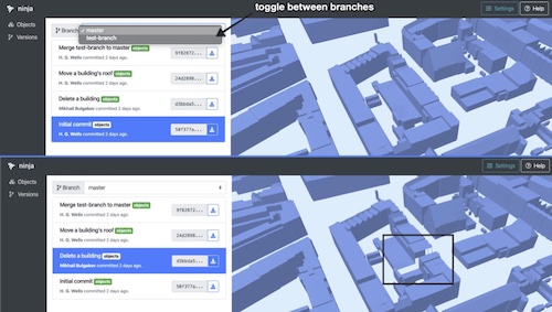
CityJSON + web = ninja. Stelios Vitalis, Anna Labetski, Freek Boersma, Felix Dahle, Xiaoai Li, Ken Arroyo Ohori, Hugo Ledoux y Jantien Stoter. En K. Wong, C. Ellul, J. Morley, R. Home y M. Kalantari (eds.), 15th 3D GeoInfo Conference, ISPRS Annals of the Photogrammetry, Remote Sensing and Spatial Information Sciences VI–4(W1–2020), ISPRS, London, United Kingdom, septiembre 2020, pp. 167–173. ISSN: 2194–9042 (Print), 2194–9050 (Internet and USB).
@incollection{203dgeoinfo_ninja,
	address = {London, United Kingdom},
	author = {Stelios Vitalis and Anna Labetski and Freek Boersma and Felix Dahle and Xiaoai Li and Ken {Arroyo Ohori} and Hugo Ledoux and Jantien Stoter},
	booktitle = {15th 3D GeoInfo Conference},
	editor = {K. Wong and C. Ellul and J. Morley and R. Home and M. Kalantari},
	month = {sep},
	note = {ISSN: 2194--9042 (Print), 2194--9050 (Internet and USB)},
	number = {W1--2020},
	pages = {167--173},
	publisher = {ISPRS},
	series = {ISPRS Annals of the Photogrammetry, Remote Sensing and Spatial Information Sciences},
	title = {{CityJSON} + web = ninja},
	volume = {VI--4},
	year = {2020}
}
Automatic conversion of CityGML to IFC. Nebras Salheb, Ken Arroyo Ohori y Jantien Stoter. En K. Wong, C. Ellul, J. Morley, R. Home y M. Kalantari (eds.), ISPRS TC IV 3rd BIM/GIS Integration Workshop and 15th 3D GeoInfo Conference 2020, International Archives of the Photogrammetry, Remote Sensing and Spatial Information Sciences XLIV–4(W1–2020), ISPRS, London, United Kingdom, septiembre 2020, pp. 127–134. ISSN: 2194–9034 (Internet and USB), 1682–1750 (Print), 1682–1777 (CD-ROM).
@incollection{203dgeoinfo_nebras,
	address = {London, United Kingdom},
	author = {Nebras Salheb and Ken {Arroyo Ohori} and Jantien Stoter},
	booktitle = {ISPRS TC IV 3rd BIM/GIS Integration Workshop and 15th 3D GeoInfo Conference 2020},
	editor = {K. Wong and C. Ellul and J. Morley and R. Home and M. Kalantari},
	month = {sep},
	note = {ISSN: 2194--9034 (Internet and USB), 1682--1750 (Print), 1682--1777 (CD-ROM)},
	number = {W1--2020},
	pages = {127--134},
	publisher = {ISPRS},
	series = {International Archives of the Photogrammetry, Remote Sensing and Spatial Information Sciences},
	title = {Automatic conversion of {CityGML} to {IFC}},
	volume = {XLIV--4},
	year = {2020}
}
The ISPRS-EuroSDR GeoBIM benchmark 2019. Francesca Noardo, Ken Arroyo Ohori, Filip Biljecki, Claire Ellul, Lars Harrie, Thomas Krijnen, Margarita Kokla y Jantien Stoter. En N. Paparoditis, C. Mallet, F. Lafarge, S. Kumar, P. L. N. Raju, S. P. Aggarwal, S. R. Reyes, M. Ustuner, F. Tsai y V. Liesenberg (eds.), XXIV ISPRS Congress, Commission V and Youth Forum, International Archives of the Photogrammetry, Remote Sensing and Spatial Information Sciences XLIII(B5), ISPRS, agosto 2020, pp. 227–233. ISSN: 2194–9034 (Internet and USB), 1682–1750 (Print), 1682–1777 (CD-ROM).
@incollection{20isprs,
	author = {Francesca Noardo and Ken {Arroyo Ohori} and Filip Biljecki and Claire Ellul and Lars Harrie and Thomas Krijnen and Margarita Kokla and Jantien Stoter},
	booktitle = {XXIV ISPRS Congress, Commission V and Youth Forum},
	editor = {N. Paparoditis and C. Mallet and F. Lafarge and S. Kumar and P. L. N. Raju and S. P. Aggarwal and S. R. Reyes and M. Ustuner and F. Tsai and V. Liesenberg},
	month = {aug},
	note = {ISSN: 2194--9034 (Internet and USB), 1682--1750 (Print), 1682--1777 (CD-ROM)},
	number = {B5},
	pages = {227--233},
	publisher = {ISPRS},
	series = {International Archives of the Photogrammetry, Remote Sensing and Spatial Information Sciences},
	title = {The {ISPRS}-{EuroSDR} {GeoBIM} benchmark 2019},
	volume = {XLIII},
	year = {2020}
}
Tools for BIM-GIS integration (IFC georeferencing and conversions): results from the GeoBIM Benchmark 2019. Francesca Noardo, Lars Harrie, Ken Arroyo Ohori, Filip Biljecki, Claire Ellul, Thomas Krijnen, Helen Eriksson, Dogus Guler, Dean Hintz, Mojgan A. Jadidi, Maria Pla, Santi Sanchez, Ville-Pekka Soini, Rudi Stouffs, Jernej Tekavec y Jantien Stoter. ISPRS International Journal of Geo-Information 9(9), agosto 2020. ISSN: 2220–9964.
@article{20ijgi_benchmark,
	author = {Francesca Noardo and Lars Harrie and Ken {Arroyo Ohori} and Filip Biljecki and Claire Ellul and Thomas Krijnen and Helen Eriksson and Dogus Guler and Dean Hintz and Mojgan A. Jadidi and Maria Pla and Santi Sanchez and Ville-Pekka Soini and Rudi Stouffs and Jernej Tekavec and Jantien Stoter},
	journal = {ISPRS International Journal of Geo-Information},
	month = {aug},
	note = {ISSN: 2220--9964},
	number = {9},
	title = {Tools for {BIM}-{GIS} Integration ({IFC} Georeferencing and Conversions): Results from the {GeoBIM} {B}enchmark 2019},
	volume = {9},
	year = {2020}
}
Validation and inference of geometrical relationships in IFC. Thomas Krijnen, Francesca Noardo, Ken Arroyo Ohori, Hugo Ledoux y Jantien Stoter. Proceedings of the 37th International Conference of CIB W78, Sao Paulo, Brazil, agosto 2020, pp. 98–111. ISSN: 2706–6568.
@inproceedings{20cibw78,
	address = {Sao Paulo, Brazil},
	author = {Thomas Krijnen and Francesca Noardo and Ken {Arroyo Ohori} and Hugo Ledoux and Jantien Stoter},
	booktitle = {Proceedings of the 37th International Conference of CIB W78},
	month = {aug},
	note = {ISSN: 2706--6568},
	pages = {98--111},
	title = {Validation and Inference of Geometrical Relationships in {IFC}},
	year = {2020}
}
Opportunities and challenges for GeoBIM in Europe: developing a building permits use-case to raise awareness and examine technical interoperability challenges. Francesca Noardo, Claire Ellul, Lars Harrie, Ivar Overland, Masoome Shariat, Ken Arroyo Ohori y Jantien Stoter. Journal of Spatial Science 65(2), mayo 2020, pp. 209-233. ISSN: 1449–8596 (Print), 1836–5655 (Online).
@article{20tjss,
	author = {Francesca Noardo and Claire Ellul and Lars Harrie and Ivar Overland and Masoome Shariat and Ken {Arroyo Ohori} and Jantien Stoter},
	journal = {Journal of Spatial Science},
	month = {may},
	note = {ISSN: 1449--8596 (Print), 1836--5655 (Online)},
	number = {2},
	pages = {209-233},
	title = {Opportunities and Challenges for {GeoBIM} in {Europe}: developing a building permits use-case to raise awareness and examine technical interoperability challenges},
	volume = {65},
	year = {2020}
}
2019
A data structure to incorporate versioning in 3D city models. Stelios Vitalis, Anna Labetski, Ken Arroyo Ohori, Hugo Ledoux y Jantien Stoter. En R. Stouffs, F. Biljecki, K. H. Soon y V. Khoo (eds.), 14th 3D GeoInfo Conference, ISPRS Annals of the Photogrammetry, Remote Sensing and Spatial Information Sciences IV-4(W8), ISPRS, Singapore, septiembre 2019, pp. 123–130. ISSN: 2194–9042 (Print), 2194–9050 (Internet and USB).
@incollection{193dgeoinfo_versioning,
	address = {Singapore},
	author = {Stelios Vitalis and Anna Labetski and Ken {Arroyo Ohori} and Hugo Ledoux and Jantien Stoter},
	booktitle = {14th 3D GeoInfo Conference},
	editor = {R. Stouffs and F. Biljecki and K. H. Soon and V. Khoo},
	month = {sep},
	note = {ISSN: 2194--9042 (Print), 2194--9050 (Internet and USB)},
	number = {W8},
	pages = {123--130},
	publisher = {ISPRS},
	series = {ISPRS Annals of the Photogrammetry, Remote Sensing and Spatial Information Sciences},
	title = {A data structure to incorporate versioning in {3D} city models},
	volume = {IV-4},
	year = {2019}
}
EuroSDR GeoBIM project: a study in Europe on how to use the potentials of BIM and Geo data in practice. Francesca Noardo, Claire Ellul, Lars Harrie, Emmanuel Devys, Ken Arroyo Ohori, Perola Olsson y Jantien Stoter. En R. Stouffs, F. Biljecki, K. H. Soon y V. Khoo (eds.), 14th 3D GeoInfo Conference, International Archives of the Photogrammetry, Remote Sensing and Spatial Information Sciences XLII-4(W15), ISPRS, Singapore, septiembre 2019, pp. 53–60. ISSN: 2194–9034 (Internet and USB), 1682–1750 (Print), 1682–1777 (CD-ROM).
@incollection{193dgeoinfo_eurosdr,
	address = {Singapore},
	author = {Francesca Noardo and Claire Ellul and Lars Harrie and Emmanuel Devys and Ken {Arroyo Ohori} and Perola Olsson and Jantien Stoter},
	booktitle = {14th 3D GeoInfo Conference},
	editor = {R. Stouffs and F. Biljecki and K. H. Soon and V. Khoo},
	month = {sep},
	note = {ISSN: 2194--9034 (Internet and USB), 1682--1750 (Print), 1682--1777 (CD-ROM)},
	number = {W15},
	pages = {53--60},
	publisher = {ISPRS},
	series = {International Archives of the Photogrammetry, Remote Sensing and Spatial Information Sciences},
	title = {{EuroSDR} {GeoBIM} project: A study in {E}urope on how to use the potentials of {BIM} and {Geo} data in practice},
	volume = {XLII-4},
	year = {2019}
}
GeoBIM benchmark 2019: intermediate results. Francesca Noardo, Filip Biljecki, Giorgio Agugiaro, Ken Arroyo Ohori, Claire Ellul, Lars Harrie y Jantien Stoter. En R. Stouffs, F. Biljecki, K. H. Soon y V. Khoo (eds.), 14th 3D GeoInfo Conference, International Archives of the Photogrammetry, Remote Sensing and Spatial Information Sciences XLII-4(W15), ISPRS, Singapore, septiembre 2019, pp. 47–52. ISSN: 2194–9034 (Internet and USB), 1682–1750 (Print), 1682–1777 (CD-ROM).
@incollection{193dgeoinfo_benchmark,
	address = {Singapore},
	author = {Francesca Noardo and Filip Biljecki and Giorgio Agugiaro and Ken {Arroyo Ohori} and Claire Ellul and Lars Harrie and Jantien Stoter},
	booktitle = {14th 3D GeoInfo Conference},
	editor = {R. Stouffs and F. Biljecki and K. H. Soon and V. Khoo},
	month = {sep},
	note = {ISSN: 2194--9034 (Internet and USB), 1682--1750 (Print), 1682--1777 (CD-ROM)},
	number = {W15},
	pages = {47--52},
	publisher = {ISPRS},
	series = {International Archives of the Photogrammetry, Remote Sensing and Spatial Information Sciences},
	title = {{GeoBIM} Benchmark 2019: Intermediate Results},
	volume = {XLII-4},
	year = {2019}
}
Incorporating topological representation in 3D city models. Stelios Vitalis, Ken Arroyo Ohori y Jantien Stoter. ISPRS International Journal of Geo-Information 8(8), agosto 2019. ISSN: 2220–9964.
@article{19ijgi_topology,
	author = {Stelios Vitalis and Ken {Arroyo Ohori} and Jantien Stoter},
	journal = {ISPRS International Journal of Geo-Information},
	month = {aug},
	note = {ISSN: 2220--9964},
	number = {8},
	title = {Incorporating Topological Representation in {3D} City Models},
	volume = {8},
	year = {2019}
}
The LandInfra standard and its role in solving the BIM-GIS quagmire. Kavisha Kumar, Anna Labetski, Ken Arroyo Ohori, Hugo Ledoux y Jantien Stoter. Open Geospatial Data, Software and Standards 4(5), julio 2019. ISSN: 2363–7501.
@article{19ogdss_landinfra,
	author = {Kavisha Kumar and Anna Labetski and Ken {Arroyo Ohori} and Hugo Ledoux and Jantien Stoter},
	journal = {Open Geospatial Data, Software and Standards},
	month = {jul},
	note = {ISSN: 2363--7501},
	number = {5},
	title = {The {LandInfra} standard and its role in solving the {BIM-GIS} quagmire},
	volume = {4},
	year = {2019}
}
CityJSON: a compact and easy-to-use encoding of the CityGML data model. Hugo Ledoux, Ken Arroyo Ohori, Kavisha Kumar, Balázs Dukai, Anna Labetski y Stelios Vitalis. Open Geospatial Data, Software and Standards 4(4), junio 2019. ISSN: 2363–7501.
@article{19ogdss_cityjson,
	author = {Hugo Ledoux and Ken {Arroyo Ohori} and Kavisha Kumar and Bal\'azs Dukai and Anna Labetski and Stelios Vitalis},
	journal = {Open Geospatial Data, Software and Standards},
	month = {jun},
	note = {ISSN: 2363--7501},
	number = {4},
	title = {{CityJSON}: A compact and easy-to-use encoding of the {CityGML} data model},
	volume = {4},
	year = {2019}
}
GeoBIM benchmark 2019: design and initial results. Francesca Noardo, Ken Arroyo Ohori, Filip Biljecki, Thomas Krijnen, Claire Ellul, Lars Harrie y Jantien Stoter. En G. Vosselman, S. J. Oude Elberink y M. Y. Yang (eds.), ISPRS Geospatial Week 2019, International Archives of the Photogrammetry, Remote Sensing and Spatial Information Sciences XLII-2(W13), ISPRS, junio 2019, pp. 1339–1346. ISSN: 2194–9034 (Internet and USB), 1682–1750 (Print), 1682–1777 (CD-ROM).
@incollection{19gsw,
	author = {Francesca Noardo and Ken {Arroyo Ohori} and Filip Biljecki and Thomas Krijnen and Claire Ellul and Lars Harrie and Jantien Stoter},
	booktitle = {ISPRS Geospatial Week 2019},
	editor = {G. Vosselman and S. J. {Oude Elberink} and and M. Y. Yang},
	month = {jun},
	note = {ISSN: 2194--9034 (Internet and USB), 1682--1750 (Print), 1682--1777 (CD-ROM)},
	number = {W13},
	pages = {1339--1346},
	publisher = {ISPRS},
	series = {International Archives of the Photogrammetry, Remote Sensing and Spatial Information Sciences},
	title = {{GeoBIM} Benchmark 2019: Design and Initial Results},
	volume = {XLII-2},
	year = {2019}
}
Harmonising the OGC standards for the built environment: a CityGML extension for LandInfra. Kavisha Kumar, Anna Labetski, Ken Arroyo Ohori, Hugo Ledoux y Jantien Stoter. ISPRS International Journal of Geo-Information 8(6), mayo 2019. ISSN: 2220–9964.
@article{19ijgi_landinfra,
	author = {Kavisha Kumar and Anna Labetski and Ken {Arroyo Ohori} and Hugo Ledoux and Jantien Stoter},
	journal = {ISPRS International Journal of Geo-Information},
	month = {may},
	note = {ISSN: 2220--9964},
	number = {6},
	title = {Harmonising the {OGC} Standards for the Built Environment: A {CityGML} Extension for {LandInfra}},
	volume = {8},
	year = {2019}
}
2018
A framework for the representation of two versions of a 3D model in 4D space. Stelios Vitalis, Ken Arroyo Ohori y Jantien Stoter. En Ken Arroyo Ohori, Anna Labetski, Giorgio Agugiaro, Mila Koeva y Jantien Stoter (eds.), 13th 3D Geoinfo Conference, ISPRS Annals of the Photogrammetry, Remote Sensing and Spatial Information Sciences IV-4(W6), ISPRS, Delft, The Netherlands, octubre 2018, pp. 81–88. ISSN: 2194–9042 (Print), 2194–9050 (Internet and USB).
@incollection{183dgeoinfo,
	address = {Delft, The Netherlands},
	author = {Stelios Vitalis and Ken {Arroyo Ohori} and Jantien Stoter},
	booktitle = {13th 3D Geoinfo Conference},
	editor = {Ken {Arroyo Ohori} and Anna Labetski and Giorgio Agugiaro and Mila Koeva and Jantien Stoter},
	month = {oct},
	note = {ISSN: 2194--9042 (Print), 2194--9050 (Internet and USB)},
	number = {W6},
	pages = {81--88},
	publisher = {ISPRS},
	series = {ISPRS Annals of the Photogrammetry, Remote Sensing and Spatial Information Sciences},
	title = {A framework for the representation of two versions of a {3D} model in {4D} space},
	volume = {IV-4},
	year = {2018}
}
Modeling cities and landscapes in 3D with CityGML. Ken Arroyo Ohori, Filip Biljecki, Kavisha Kumar, Hugo Ledoux y Jantien Stoter. En André Borrmann, Markus König, Christian Koch y Jakob Beetz (eds.), Building Information Modeling: Technology Foundations and Industry Practice, Springer, septiembre 2018, pp. 199–215. ISBN: 978–3–319–92861–6 (Print) 978–3–319–92862–3 (Online).
@incollection{18bimchapter,
	author = {Ken {Arroyo Ohori} and Filip Biljecki and Kavisha Kumar and Hugo Ledoux and Jantien Stoter},
	booktitle = {Building Information Modeling: Technology Foundations and Industry Practice},
	editor = {Andr\'e Borrmann and Markus K\"onig and Christian Koch and Jakob Beetz},
	month = {sep},
	note = {ISBN: 978--3--319--92861--6 (Print) 978--3--319--92862--3 (Online)},
	pages = {199--215},
	publisher = {Springer},
	title = {Modeling Cities and Landscapes in {3D} with {CityGML}},
	year = {2018}
}
Processing BIM and GIS models in practice: experiences and recommendations from a GeoBIM project in the Netherlands. Ken Arroyo Ohori, Abdoulaye Diakité, Thomas Krijnen, Hugo Ledoux y Jantien Stoter. ISPRS International Journal of Geo-Information 7(8), agosto 2018. ISSN: 2220–9964.
@article{18ijgi,
	author = {Ken {Arroyo Ohori} and Abdoulaye Diakit\'e and Thomas Krijnen and Hugo Ledoux and Jantien Stoter},
	journal = {ISPRS International Journal of Geo-Information},
	month = {aug},
	note = {ISSN: 2220--9964},
	number = {8},
	title = {Processing {BIM} and {GIS} Models in Practice: Experiences and Recommendations from a {GeoBIM} Project in The {N}etherlands},
	volume = {7},
	year = {2018}
}
Topological reconstruction of 3D city models with preservation of semantics. Stelios Vitalis, Ken Arroyo Ohori y Jantien Stoter. En A. Mansourian, P. Pilesjö, L. Harrie y R. von Lammeren (eds.), Geospatial Technologies for All: short papers, posters and poster abstracts of the 21th AGILE Conference on Geographic Information Science. Lund University 12-15 June 2018, Lund, Sweden, junio 2018. ISBN: 978–3–319–78208–9.
@inproceedings{18agile,
	address = {Lund, Sweden},
	author = {Stelios Vitalis and Ken {Arroyo Ohori} and Jantien Stoter},
	booktitle = {Geospatial Technologies for All: short papers, posters and poster abstracts of the 21th AGILE Conference on Geographic Information Science. Lund University 12-15 June 2018},
	editor = {Mansourian, A. and Pilesj{\"{o}}, P. and Harrie, L. and von Lammeren, R.},
	month = {jun},
	note = {ISBN: 978--3--319--78208--9},
	title = {Topological Reconstruction of {3D} City Models with preservation of semantics},
	year = {2018}
}
Essential means for urban computing: specification of web-based computing platforms for urban planning, a hitchhiker’s guide. Pirouz Nourian, Carlos Martinez-Ortiz y Ken Arroyo Ohori. Urban Planning 3(1), marzo 2018, pp. 47–57. ISSN: 2183–7635.
@article{18up,
	author = {Pirouz Nourian and Carlos Martinez-Ortiz and Ken {Arroyo Ohori}},
	journal = {Urban Planning},
	month = {mar},
	note = {ISSN: 2183--7635},
	number = {1},
	pages = {47--57},
	title = {Essential Means for Urban Computing: Specification of Web-Based Computing Platforms for Urban Planning, a Hitchhiker's Guide},
	volume = {3},
	year = {2018}
}
2017
Towards an integration of GIS and BIM data: what are the geometric and topological issues?. Ken Arroyo Ohori, Filip Biljecki, Abdoulaye Diakité, Thomas Krijnen, Hugo Ledoux y Jantien Stoter. En M. Kalantari y A. Rajabifard (eds.), 12th 3D Geoinfo Conference, ISPRS Annals of the Photogrammetry, Remote Sensing and Spatial Information Sciences IV–4/W5, ISPRS, Melbourne, Australia, octubre 2017, pp. 1–8. ISSN: 2194–9042 (Print), 2194–9050 (Internet and USB).
@incollection{173dgeoinfo,
	address = {Melbourne, Australia},
	author = {Ken {Arroyo Ohori} and Filip Biljecki and Abdoulaye Diakit\'e and Thomas Krijnen and Hugo Ledoux and Jantien Stoter},
	booktitle = {12th 3D Geoinfo Conference},
	editor = {M. Kalantari and A. Rajabifard},
	month = {oct},
	note = {ISSN: 2194--9042 (Print), 2194--9050 (Internet and USB)},
	pages = {1--8},
	publisher = {ISPRS},
	series = {ISPRS Annals of the Photogrammetry, Remote Sensing and Spatial Information Sciences},
	title = {Towards an integration of {GIS} and {BIM} data: what are the geometric and topological issues?},
	volume = {IV--4/W5},
	year = {2017}
}
Visualising higher-dimensional space-time and space-scale objects as projections to R3. Ken Arroyo Ohori, Hugo Ledoux y Jantien Stoter. PeerJ Computer Science 3:e123, julio 2017. ISSN: 2376–5992.
@article{17peerj,
	author = {Ken {Arroyo Ohori} and Hugo Ledoux and Jantien Stoter},
	journal = {PeerJ Computer Science},
	month = {jul},
	note = {ISSN: 2376--5992},
	title = {Visualising higher-dimensional space-time and space-scale objects as projections to {R3}},
	volume = {3:e123},
	year = {2017}
}
Modelling and manipulating spacetime objects in a true 4D model. Ken Arroyo Ohori, Hugo Ledoux y Jantien Stoter. Journal of Spatial Information Science 14, junio 2017, pp. 61–93. ISSN: 1948–660X.
@article{17josis,
	author = {Ken {Arroyo Ohori} and Hugo Ledoux and Jantien Stoter},
	journal = {Journal of Spatial Information Science},
	month = {jun},
	note = {ISSN: 1948--660X},
	pages = {61--93},
	title = {Modelling and manipulating spacetime objects in a true {4D} model},
	volume = {14},
	year = {2017}
}
Solving the horizontal conflation problem with a constrained Delaunay triangulation. Hugo Ledoux y Ken Arroyo Ohori. Journal of Geographical Systems 19(1), enero 2017, pp. 21–42. ISSN: 1435–5930 (print version), 1435–5949 (electronic version).
@article{17jgsy,
	author = {Hugo Ledoux and Ken {Arroyo Ohori}},
	journal = {Journal of Geographical Systems},
	month = {jan},
	note = {ISSN: 1435--5930 (print version), 1435--5949 (electronic version)},
	number = {1},
	pages = {21--42},
	title = {Solving the horizontal conflation problem with a constrained {D}elaunay triangulation},
	volume = {19},
	year = {2017}
}
2016
Defining simple nD operations based on prismatic nD objects. Ken Arroyo Ohori, Hugo Ledoux y Jantien Stoter. En E. Dimopoulou y P. van Oosterom (eds.), 11th 3D Geoinfo Conference, ISPRS Annals of the Photogrammetry, Remote Sensing and Spatial Information Sciences IV–2/W1, ISPRS, Athens, Greece, octubre 2016, pp. 155–162. ISSN: 2194–9042 (Print), 2194–9050 (Internet and USB).
@incollection{163dgeoinfo,
	address = {Athens, Greece},
	author = {Ken {Arroyo Ohori} and Hugo Ledoux and Jantien Stoter},
	booktitle = {11th 3D Geoinfo Conference},
	editor = {E. Dimopoulou and P. {van Oosterom}},
	month = {oct},
	note = {ISSN: 2194--9042 (Print), 2194--9050 (Internet and USB)},
	pages = {155--162},
	publisher = {ISPRS},
	series = {ISPRS Annals of the Photogrammetry, Remote Sensing and Spatial Information Sciences},
	title = {Defining simple n{D} operations based on prismatic n{D} objects},
	volume = {IV--2/W1},
	year = {2016}
}
Population estimation using a 3D city model: a multi-scale country-wide study in the Netherlands. Filip Biljecki, Ken Arroyo Ohori, Hugo Ledoux, Ravi Peters y Jantien Stoter. PLOS ONE 11(6), junio 2016. ISSN: 1932–6203.
@article{16plosone,
	author = {Filip Biljecki and Ken {Arroyo Ohori} and Hugo Ledoux and Ravi Peters and Jantien Stoter},
	journal = {PLOS ONE},
	month = {jun},
	note = {ISSN: 1932--6203},
	number = {6},
	title = {Population Estimation Using a {3D} City Model: A Multi-Scale Country-Wide Study in the {N}etherlands},
	volume = {11},
	year = {2016}
}
Voxelization algorithms for geospatial applications: computational methods for voxelating spatial datasets of 3D city models containing 3D surface, curve and point data models. Pirouz Nourian, Romulo Gonçalves, Sisi Zlatanova, Ken Arroyo Ohori y Anh Vu Vo. MethodsX 3, enero 2016, pp. 69–86. ISSN: 2215–0161.
@article{16methodsx,
	author = {Pirouz Nourian and Romulo Gon\c{c}alves and Sisi Zlatanova and Ken {Arroyo Ohori} and Anh Vu Vo},
	journal = {MethodsX},
	month = {jan},
	note = {ISSN: 2215--0161},
	pages = {69--86},
	title = {Voxelization Algorithms for Geospatial Applications: Computational methods for voxelating spatial datasets of {3D} city models containing {3D} surface, curve and point data models},
	volume = {3},
	year = {2016}
}
2015
Automatically enhancing CityGML LOD2 models with a corresponding indoor geometry. Roeland Boeters, Ken Arroyo Ohori, Filip Biljecki y Sisi Zlatanova. International Journal of Geographical Information Science 29(12), diciembre 2015, pp. 2248–2268. ISSN: 1365–8816 (Print), 1362–3087 (Online).
@article{15ijgis_roeland,
	author = {Roeland Boeters and Ken {Arroyo Ohori} and Filip Biljecki and Sisi Zlatanova},
	journal = {International Journal of Geographical Information Science},
	month = {dec},
	note = {ISSN: 1365--8816 (Print), 1362--3087 (Online)},
	number = {12},
	pages = {2248--2268},
	title = {Automatically enhancing {CityGML} {LOD2} models with a corresponding indoor geometry},
	volume = {29},
	year = {2015}
}
Automatic semantic-preserving conversion between OBJ and CityGML. Filip Biljecki y Ken Arroyo Ohori. En F. Biljecki y V. Tourre (eds.), Eurographics Workshop on Urban Data Modelling and Visualisation, Eurographics Association, Delft, The Netherlands, noviembre 2015, pp. 25–30. ISBN: 978–3–905674–80–4 ISSN: 2307–8251.
@incollection{15udmv,
	address = {Delft, The Netherlands},
	author = {Filip Biljecki and Ken {Arroyo Ohori}},
	booktitle = {Eurographics Workshop on Urban Data Modelling and Visualisation},
	editor = {F. Biljecki and V. Tourre},
	month = {nov},
	note = {ISBN: 978--3--905674--80--4 ISSN: 2307--8251},
	pages = {25--30},
	publisher = {Eurographics Association},
	title = {Automatic semantic-preserving conversion between {OBJ} and {CityGML}},
	year = {2015}
}
Storing a 3D city model, its levels of detail and the correspondences between objects as a 4D combinatorial map. Ken Arroyo Ohori, Hugo Ledoux y Jantien Stoter. En Alias Abdul Rahman, Umit Isikdag y Francesc Antón Castro (eds.), ISPRS Joint International Geoinformation Conference 2015, ISPRS Annals of the Photogrammetry, Remote Sensing and Spatial Information Sciences II–2/W2, ISPRS, Kuala Lumpur, Malaysia, octubre 2015, pp. 1–8. ISSN: 2194–9042 (Print), 2194–9050 (Internet and USB).
@incollection{15isprs,
	address = {Kuala Lumpur, Malaysia},
	author = {Ken {Arroyo Ohori} and Hugo Ledoux and Jantien Stoter},
	booktitle = {ISPRS Joint International Geoinformation Conference 2015},
	editor = {Alias Abdul Rahman and Umit Isikdag and Francesc Ant\'on Castro},
	month = {oct},
	note = {ISSN: 2194--9042 (Print), 2194--9050 (Internet and USB)},
	pages = {1--8},
	publisher = {ISPRS},
	series = {ISPRS Annals of the Photogrammetry, Remote Sensing and Spatial Information Sciences},
	title = {Storing a {3D} city model, its levels of detail and the correspondences between objects as a {4D} combinatorial map},
	volume = {II--2/W2},
	year = {2015}
}
Modelling a 3D city model and its levels of detail as a true 4D model. Ken Arroyo Ohori, Hugo Ledoux, Filip Biljecki y Jantien Stoter. ISPRS International Journal of Geo-Information 4(3), septiembre 2015, pp. 1055–1075. ISSN: 2220–9964.
@article{15ijgi,
	author = {Ken {Arroyo Ohori} and Hugo Ledoux and Filip Biljecki and Jantien Stoter},
	journal = {ISPRS International Journal of Geo-Information},
	month = {sep},
	note = {ISSN: 2220--9964},
	number = {3},
	pages = {1055--1075},
	title = {Modelling a {3D} city model and its levels of detail as a true {4D} model},
	volume = {4},
	year = {2015}
}
A dimension-independent extrusion algorithm using generalised maps. Ken Arroyo Ohori, Hugo Ledoux y Jantien Stoter. International Journal of Geographical Information Science 29(7), julio 2015, pp. 1166–1186. ISSN: 1365–8816 (Print), 1362–3087 (Online).
@article{15ijgis_extrusion,
	author = {Ken {Arroyo Ohori} and Hugo Ledoux and Jantien Stoter},
	journal = {International Journal of Geographical Information Science},
	month = {jul},
	note = {ISSN: 1365--8816 (Print), 1362--3087 (Online)},
	number = {7},
	pages = {1166--1186},
	title = {A dimension-independent extrusion algorithm using generalised maps},
	volume = {29},
	year = {2015}
}
An evaluation and classification of nD topological data structures for the representation of objects in a higher-dimensional GIS. Ken Arroyo Ohori, Hugo Ledoux y Jantien Stoter. International Journal of Geographical Information Science 29(5), mayo 2015, pp. 825–849. ISSN: 1365–8816 (Print), 1362–3087 (Online).
@article{15ijgis_ndstructures,
	author = {Ken {Arroyo Ohori} and Hugo Ledoux and Jantien Stoter},
	journal = {International Journal of Geographical Information Science},
	month = {may},
	note = {ISSN: 1365--8816 (Print), 1362--3087 (Online)},
	number = {5},
	pages = {825--849},
	title = {An evaluation and classification of {nD} topological data structures for the representation of objects in a higher-dimensional {GIS}},
	volume = {29},
	year = {2015}
}
2014
A triangulation-based approach to automatically repair GIS polygons. Hugo Ledoux, Ken Arroyo Ohori y Martijn Meijers. Computers & Geosciences 66, mayo 2014, pp. 121–131. ISSN: 0098–3004.
@article{14cg,
	author = {Hugo Ledoux and Ken {Arroyo Ohori} and Martijn Meijers},
	journal = {Computers \& Geosciences},
	month = {may},
	note = {ISSN: 0098--3004},
	pages = {121--131},
	title = {A triangulation-based approach to automatically repair {GIS} polygons},
	volume = {66},
	year = {2014}
}
Constructing an n-dimensional cell complex from a soup of (n-1)-dimensional faces. Ken Arroyo Ohori, Guillaume Damiand y Hugo Ledoux. En Prosenjit Gupta y Christos Zaroliagis (eds.), Applied Algorithms. First International Conference, ICAA 2014, Kolkata, India, January 13-15, 2014. Proceedings, Lecture Notes in Computer Science 8321, Springer International Publishing Switzerland, Kolkata, India, enero 2014, pp. 37–48. ISBN: 978–3–319–04125–4 (Print) 978–3–319–04126–1 (Online) ISSN: 0302–9743 (Print) 1611–3349 (Online).
@incollection{14icaa,
	address = {Kolkata, India},
	author = {Ken {Arroyo Ohori} and Guillaume Damiand and Hugo Ledoux},
	booktitle = {Applied Algorithms. First International Conference, ICAA 2014, Kolkata, India, January 13-15, 2014. Proceedings},
	editor = {Prosenjit Gupta and Christos Zaroliagis},
	month = {jan},
	note = {ISBN: 978--3--319--04125--4 (Print) 978--3--319--04126--1 (Online) ISSN: 0302--9743 (Print) 1611--3349 (Online)},
	pages = {37--48},
	publisher = {Springer International Publishing Switzerland},
	series = {Lecture Notes in Computer Science},
	title = {Constructing an n-dimensional cell complex from a soup of (n-1)-dimensional faces},
	volume = {8321},
	year = {2014}
}
2013
Using extrusion to generate higher-dimensional GIS datasets. Ken Arroyo Ohori y Hugo Ledoux. En Craig Knoblock, Peer Kröger, John Krumm, Markus Schneider y Peter Widmayer (eds.), SIGSPATIAL’13: Proceedings of the 21st ACM SIGSPATIAL International Conference on Advances in Geographic Information Systems, ACM, Orlando, United States, noviembre 2013, pp. 398–401. ISBN: 978–1–4503–2521–9.
@incollection{13acmsigspatial,
	address = {Orlando, United States},
	author = {Ken {Arroyo Ohori} and Hugo Ledoux},
	booktitle = {SIGSPATIAL'13: Proceedings of the 21st ACM SIGSPATIAL International Conference on Advances in Geographic Information Systems},
	editor = {Craig Knoblock and Peer Kr\"oger and John Krumm and Markus Schneider and Peter Widmayer},
	month = {nov},
	note = {ISBN: 978--1--4503--2521--9},
	pages = {398--401},
	publisher = {ACM},
	title = {Using extrusion to generate higher-dimensional {GIS} datasets},
	year = {2013}
}
Modelling higher dimensional data for GIS using generalised maps. Ken Arroyo Ohori, Hugo Ledoux y Jantien Stoter. En B. Murgante, S. Misra, M. Carlini, C. Torre, H. Q. Nguyen, D. Taniar, B. Apduhan y O. Gervasi (eds.), Computational Science and Its Applications — ICCSA 2013. 13th International Conference, Ho Chi Minh City, Vietnam, June 24–27, 2013, Proceedings, Part I, Lecture Notes in Computer Science 7971, Springer Berlin Heidelberg, Ho Chi Minh City, Vietnam, junio 2013, pp. 526–539. ISBN: 978–3–642–39636–6 (Print) 978–3–642–39637–3 (Online) ISSN: 0302–9743 (Print) 1611–3349 (Online).
@incollection{13iccsa,
	address = {Ho Chi Minh City, Vietnam},
	author = {Ken {Arroyo Ohori} and Hugo Ledoux and Jantien Stoter},
	booktitle = {Computational Science and Its Applications --- ICCSA 2013. 13th International Conference, Ho Chi Minh City, Vietnam, June 24--27, 2013, Proceedings, Part I},
	editor = {B. Murgante and S. Misra and M. Carlini and C. Torre and H.Q. Nguyen and D. Taniar and B. Apduhan and O. Gervasi},
	month = {jun},
	note = {ISBN: 978--3--642--39636--6 (Print) 978--3--642--39637--3 (Online) ISSN: 0302--9743 (Print) 1611--3349 (Online)},
	pages = {526--539},
	publisher = {Springer Berlin Heidelberg},
	series = {Lecture Notes in Computer Science},
	title = {Modelling Higher Dimensional Data for {GIS} Using Generalised Maps},
	volume = {7971},
	year = {2013}
}
Representing the dual of objects in a four-dimensional GIS. Ken Arroyo Ohori, Pawel Boguslawski y Hugo Ledoux. En A. Abdul Rahman, P. Boguslawski, C. Gold y M. N. Said (eds.), Developments in Multidimensional Spatial Data Models, Lecture Notes in Geoinformation and Cartography, Springer Berlin Heidelberg, Johor Bahru, Malaysia, mayo 2013, pp. 17–31. ISBN: 978–3–642–36378–8 (Print) 978–3–642–36379–5 (Online) ISSN: 1863–2246 (Print) 1863–2351 (Online).
@incollection{13geoadvances,
	address = {Johor Bahru, Malaysia},
	author = {Ken {Arroyo Ohori} and Pawel Boguslawski and Hugo Ledoux},
	booktitle = {Developments in Multidimensional Spatial Data Models},
	editor = {Abdul Rahman, A. and Boguslawski, P. and Gold, C. and Said, M.N.},
	month = {may},
	note = {ISBN: 978--3--642--36378--8 (Print) 978--3--642--36379--5 (Online) ISSN: 1863--2246 (Print) 1863--2351 (Online)},
	pages = {17--31},
	publisher = {Springer Berlin Heidelberg},
	series = {Lecture Notes in Geoinformation and Cartography},
	title = {Representing the dual of objects in a four-dimensional {GIS}},
	year = {2013}
}
Manipulating higher dimensional spatial information. Ken Arroyo Ohori, Filip Biljecki, Jantien Stoter y Hugo Ledoux. En Danny Vandenbroucke, Bénédicte Bucher y Joep Crompvoets (eds.), Geographic Information Science at the Heart of Europe. Proceedings of the 16th AGILE International Conference on Geographic Information Science, Leuven, Belgium, mayo 2013.
@inproceedings{13agile,
	address = {Leuven, Belgium},
	author = {Ken {Arroyo Ohori} and Filip Biljecki and Jantien Stoter and Hugo Ledoux},
	booktitle = {Geographic Information Science at the Heart of Europe. Proceedings of the 16th AGILE International Conference on Geographic Information Science},
	editor = {Danny Vandenbroucke and B\'en\'edicte Bucher and Joep Crompvoets},
	month = {may},
	title = {Manipulating higher dimensional spatial information},
	year = {2013}
}
2012
Validation and automatic repair of planar partitions using a constrained triangulation. Ken Arroyo Ohori, Hugo Ledoux y Martijn Meijers. Photogrammetrie, Fernerkundung, Geoinformation 5, octubre 2012, pp. 613–630. ISSN: 1432–8364.
@article{12pfg,
	author = {Ken {Arroyo Ohori} and Hugo Ledoux and Martijn Meijers},
	journal = {Photogrammetrie, Fernerkundung, Geoinformation},
	month = {oct},
	note = {ISSN: 1432--8364},
	pages = {613--630},
	title = {Validation and Automatic Repair of Planar Partitions Using a Constrained Triangulation},
	volume = {5},
	year = {2012}
}
Automatically repairing polygons and planar partitions with prepair and pprepair. Ken Arroyo Ohori, Hugo Ledoux y Martijn Meijers. Proceedings of the 4th Open Source GIS UK Conference, Nottingham, United Kingdom, septiembre 2012.
@inproceedings{12osgis,
	address = {Nottingham, United Kingdom},
	author = {Ken {Arroyo Ohori} and Hugo Ledoux and Martijn Meijers},
	booktitle = {Proceedings of the 4th Open Source GIS UK Conference},
	month = {sep},
	title = {Automatically repairing polygons and planar partitions with prepair and pprepair},
	year = {2012}
}
Integrating scale and space in 3D city models. Jantien Stoter, Hugo Ledoux, Martijn Meijers y Ken Arroyo Ohori. En Jacynthe Pouliot, Sylvie Daniel, Frédéric Hubert y Alborz Zamyadi (eds.), Proceedings of the 7th International 3D GeoInfo Conference, International Archives of the Photogrammetry, Remote Sensing and Spatial Information Sciences XXXVIII-4/C26, ISPRS, Québec City, Canada, mayo 2012, pp. 7–10. ISSN: 2194–9034 (Internet and USB), 1682–1750 (Print), 1682–1777 (CD-ROM).
@incollection{123dgeoinfo,
	address = {Qu\'ebec City, Canada},
	author = {Jantien Stoter and Hugo Ledoux and Martijn Meijers and Ken {Arroyo Ohori}},
	booktitle = {Proceedings of the 7th International 3D GeoInfo Conference},
	editor = {Jacynthe Pouliot and Sylvie Daniel and Fr{\'e}d{\'e}ric Hubert and Alborz Zamyadi},
	month = {may},
	note = {ISSN: 2194--9034 (Internet and USB), 1682--1750 (Print), 1682--1777 (CD-ROM)},
	pages = {7--10},
	publisher = {ISPRS},
	series = {International Archives of the Photogrammetry, Remote Sensing and Spatial Information Sciences},
	title = {Integrating Scale and Space in {3D} City Models},
	volume = {XXXVIII-4/C26},
	year = {2012}
}
Automatically repairing invalid polygons with a constrained triangulation. Hugo Ledoux, Ken Arroyo Ohori y Martijn Meijers. En Jérôme Gensel, Didier Josselin y Danny Vandenbroucke (eds.), Multidisciplinary Research on Geographical Information in Europe and Beyond. Proceedings of the 15th AGILE International Conference on Geographic Information Science, Avignon, France, abril 2012, pp. 13–18. ISBN: 978–90–816960–0–5.
@inproceedings{12agile,
	address = {Avignon, France},
	author = {Hugo Ledoux and Ken {Arroyo Ohori} and Martijn Meijers},
	booktitle = {Multidisciplinary Research on Geographical Information in Europe and Beyond. Proceedings of the 15th AGILE International Conference on Geographic Information Science},
	editor = {J\'er\^ome Gensel and Didier Josselin and Danny Vandenbroucke},
	month = {apr},
	note = {ISBN: 978--90--816960--0--5},
	pages = {13--18},
	title = {Automatically repairing invalid polygons with a constrained triangulation},
	year = {2012}
}
2011
Edge-matching polygons with a constrained triangulation. Hugo Ledoux y Ken Arroyo Ohori. Proceedings of GIS Ostrava 2011, Ostrava, Czech Republic, enero 2011, pp. 377–390. ISBN: 978–80–248–2366–9 ISSN: 1213–239X.
@inproceedings{11ostrava,
	address = {Ostrava, Czech Republic},
	author = {Ledoux, Hugo and Arroyo Ohori, Ken},
	booktitle = {Proceedings of GIS Ostrava 2011},
	month = {jan},
	note = {ISBN: 978--80--248--2366--9 ISSN: 1213--239X},
	pages = {377--390},
	title = {Edge-matching polygons with a constrained triangulation},
	year = {2011}
}