

Urban modelling in higher dimensions, UMnD for short, is a project funded by the ERC Starting Grant ERC-StG-2015, which awarded 1.5 million euros to Jantien Stoter for a five-year research project. It started in September 2016 and is scheduled to run until May 2022. The Amsterdam Institute of Advanced Metropolitan Solutions funds the implementation of the UMnD research results for urban applications in Amsterdam.
Latest activities
- 01 Aug 2022 Research Line 1, 2, 3: Published paper: "3D building metrics for urban morphology"
- 11 Mar 2022 Research Line 1, 2, 3: Presented "3D Building Metrics for Urban Morphology" at the Urban Analytics Lab Seminar Series at the National University of Singapore
- 22 Feb 2022 Research Line 1, 2: Published paper: "From road centrelines to carriageways—A reconstruction algorithm"
- 02 Nov 2021 Research Line 1, 2, 3: Awarded the Geospatial World Excellence Award at GWF 2021 for developing the 3D BAG platform.
- 14 Oct 2021 Research Line 1, 2, 3: Awarded the Outstanding paper: 3D Processing & Visualization title in 3D Geoinfo 2021, for participating in Clara et al's publication 'The impact of level of detail in 3D city models for CFD-based wind flow simulations'.
Table of Contents
Objective
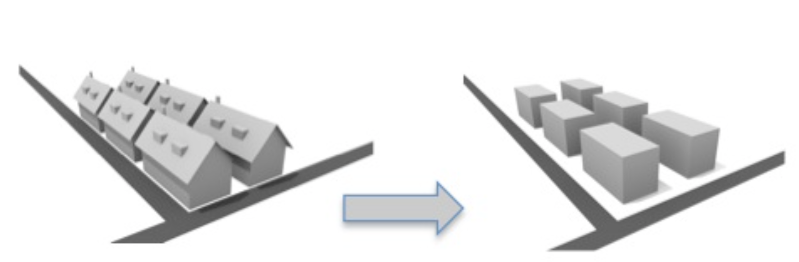
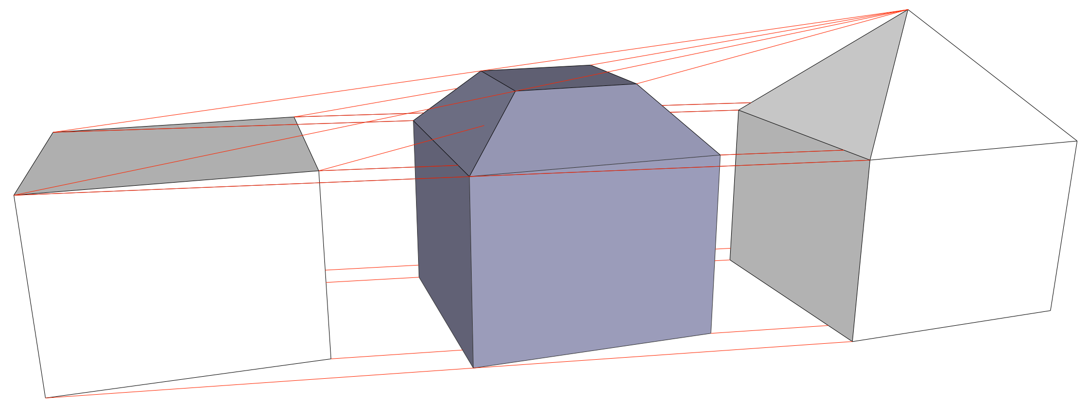
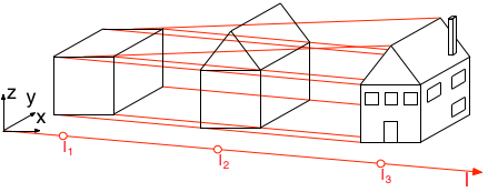
3D geographic information about urban objects (buildings, roads) is needed to monitor and control processes within modern urban areas (noise, flooding, energy demand-supply). However, each specific process requires 3D data with its own specific semantic and geometric Level of Detail (LoD), and current approaches require enormous manual efforts to collect general-purpose 3D data and to transform it to make it suitable for a specific application.
In this project, we will develop a fundamental solution for providing 3D data at application specific LoDs. For this, we will use an innovative method that goes far beyond the state-of-the-art by introducing higher dimensional (nD) mathematical models, which will enable us to to enforce consistency by modelling the LoDs as an extra dimension to the 3D spatial dimensions in an integrated 3D+LoD (4D) model.
We have defined three key research lines for the project: (i) a groundbreaking extension of 2D cartographic generalisation solutions to 3D, enabling us to automatically derive application-specific coarse 3D data from fine 3D data; (ii) embedding multiple 3D city models at different levels of detail into a single 4D model; and (iii) “slicing” operations that extract custom 3D cross-sections of the 4D model. By combining the results of these three lines of research, we aim to generate error-free 3D data at application specific LoDs.
If successful, the 4D approach opens a new horizon for modelling parametrisable aspects of urban environments, which may establish new modelling paradigms in the future.
Research Lines
Generalisation of 3D City Models
Construction and Storage of 4D City Objects
Extraction of 3D City Objects from a 4D Model
Events
The following is the list of events that we participated in or organised related to the UMnD project:
2021
- Geospatial World Forum 2021, Amsterdam, 20 - 22 October
- FOSS4G 2021, Buenos Aires (Online), 27 September - 2 October
2020
2019
- EuroSDR - AMS GeoBIM benchmark workshop, Amsterdam, 2 and 3 December
- 3D GeoInfo 2019 Conference, Singapore, 26 and 27 September
- 2nd International IAG Workshop on BIM and GIS Integration, Singapore, 25 September
2018
- 3D GeoInfo 2018 Conference, TU Delft, 1 and 2 October
- 3D GeoInfo 2018 pre-conference workshop, TU Delft, 30 September
- Urbanism PhD Day 2018, TU Delft, 15 June
- International Symposium on Point Cloud Processing, TU Delft, 13 March
2017
- Urbanism PhD Day 2017, TU Delft, 10 May
- EuroSDR workshop on economic value of 3D Geoinformation, ICGC Barcelona, 30-31 March
- PhD Symposium with TU München, TU Delft, 23-24 March
- Open Geospatial Consortium TC Meeting, TU Delft, 20-24 March
- Symposium 3D urban modelling, AMS Amsterdam, 15 March
- National 3D symposium, Provinciehuis Utrecht, 15 November
Activities
- 01 Aug 2022 Published paper: "3D building metrics for urban morphology" Related to research line(s) 1, 2, 3.
- 11 Mar 2022 Presented "3D Building Metrics for Urban Morphology" at the Urban Analytics Lab Seminar Series at the National University of Singapore Related to research line(s) 1, 2, 3.
- 22 Feb 2022 Published paper: "From road centrelines to carriageways—A reconstruction algorithm" Related to research line(s) 1, 2.
- 02 Nov 2021 Awarded the Geospatial World Excellence Award at GWF 2021 for developing the 3D BAG platform. Related to research line(s) 1, 2, 3.
- 14 Oct 2021 Awarded the Outstanding paper: 3D Processing & Visualization title in 3D Geoinfo 2021, for participating in Clara et al's publication 'The impact of level of detail in 3D city models for CFD-based wind flow simulations'. Related to research line(s) 1, 2, 3.
- 30 Sep 2021 Presented at FOSS 4G 2021, Buenos Aires a presentation titled: 'CityJSON: 3D city models for everyone'. Related to research line(s) 2.
- 29 Sep 2021 Presented at FOSS 4G 2021, Buenos Aires a presentation titled: 'A fast web 3D viewer for 11 million buildings'. Related to research line(s) 2.
- 01 Jul 2021 Presented at the ISPRS TC IV Webinar Series 'State-of-the-art in Spatial Information Science', presentation titled: 'CityJSON, a JSON-based encoding for storing 3D city models' Related to research line(s) 2, 3.
- 19 Nov 2020 Published paper: "Built Environmental Correlates of Cycling Accidents Involving Fatalities and Serious Injuries in London, UK" Related to research line(s) 1.
- 10 Sep 2020 Presented paper: "CityJSON + web = ninja" at the 2020 3D GeoInfo Conference. Related to research line(s) 1, 2, 3.
- 03 Jul 2020 Utilised as one of the references for the Dutch network modelling proposal for roads, "Conceptueel model netwerken" by the Ministerie van Infrastructuur en Waterstaat Related to research line(s) 1.
- 24 Jun 2020 Published paper: "CityJSON in QGIS: development of an open-source plugin" Related to research line(s) 2, 3.
- 16 Jun 2020 Published paper: "Flood damage cost estimation in 3D based on an indicator modelling framework" Related to research line(s) 1.
- 14 May 2020 Invited talk '3D Gebouw Reconstructie uit BAG+AHN3' by Ravi on De Grote Geo Show. Related to research line(s) 1, 2, 3.
- 30 Apr 2020 Invited talk 'wat doet TU3D?' by Hugo on De Grote Geo Show. Related to research line(s) 1, 2, 3.
- 18 Mar 2020 Article published in the GIM International Magazine: Business Guide 2020. Related to research line(s) 1, 2, 3.
- 03 Dec 2019 Stelios Vitalis presented about versioning of 3D city models at the EuroSDR - AMS GeoBIM benchmark workshop. Related to research line(s) 2.
- 02 Dec 2019 Anna Labetski presented about "open" geospatial standards at the EuroSDR - AMS GeoBIM benchmark workshop. Related to research line(s) 1.
- 02 Dec 2019 Stelios Vitalis presented about CityGML support in software at the EuroSDR - AMS GeoBIM benchmark workshop. Related to research line(s) 2.
- 18 Oct 2019 Anna Labetski completed a 2 month research visit at the Singapore Land Authority with the Survey and Geomatics Division. Related to research line(s) 1.
- 27 Sep 2019 Presented paper: "An Improved LOD Framework for the Terrains in 3D City Models" at the 2019 3D GeoInfo Conference. Related to research line(s) 1.
- 27 Sep 2019 Presented paper: "A Survey on the Adoption of GIS Data and Standards in Urban Application Domains" at the 2019 3D GeoInfo Conference. Related to research line(s) 1.
- 27 Sep 2019 Presented paper: "A Data Structure to Incorporate Versioning in 3D City Models" at the 2019 3D GeoInfo Conference. Related to research line(s) 1, 2, 3.
- 27 Sep 2019 Awarded Best Paper Award (Runner-up) for the paper: "A Data Structure to Incorporate Versioning in 3D City Models" at the 2019 3D GeoInfo Conference. Related to research line(s) 1, 2, 3.
- 25 Sep 2019 Presented paper: "GeoBIM Benchmark 2019: Intermediate Results" at the 2nd International IAG Workshop on BIM and GIS Integration. Related to research line(s) 3.
- 25 Sep 2019 Presented paper: "EuroSDR GeoBIM Project a Study in Europe on how to use the Potentials of BIM and Geo Data in Practice" at the 2nd International IAG Workshop on BIM and GIS Integration. Related to research line(s) 3.
- 07 Aug 2019 The first stable version of our CityJSON loader plugin for QGIS is officially accepted in the QGIS plugins' repository. Related to research line(s) 1, 2.
- 02 Aug 2019 Published paper: "Incorporating Topological Representation in 3D City Models" Related to research line(s) 2.
- 15 Jul 2019 Published paper: "The LandInfra standard and its role in solving the BIM-GIS quagmire" Related to research line(s) 1, 3.
- 17 Jun 2019 Published paper: "CityJSON: a compact and easy-to-use encoding of the CityGML data model." Related to research line(s) 1, 2, 3.
- 29 May 2019 Published paper: "Harmonising the OGC Standards for the Built Environment: A CityGML Extension for LandInfra" Related to research line(s) 1, 3.
- 08 Mar 2019 Anna Labetski completed a 1 week research visit at University College London Related to research line(s) 1.
- 22 Jan 2019 Invited talk 'Improving the usability of 3D city models' by Hugo at the Universität Münster GI-Forum Related to research line(s) 1, 2, 3.
- 30 Nov 2018 Published paper: "A metadata ADE for CityGML" Related to research line(s) 1.
- 02 Oct 2018 Organised the 2018 3D GeoInfo Conference in Delft. Related to research line(s) 1, 2, 3.
- 01 Oct 2018 Presented paper: "A proposal for an improved transportation model in CityGML" in the 2018 3D GeoInfo Conference Related to research line(s) 1.
- 01 Oct 2018 Presented paper: "A framework for the representation of two versions of a 3D model in 4D space" in the 2018 3D GeoInfo Conference Related to research line(s) 2.
- 30 Sep 2018 Organised the pre-conference workshop "Automated reconstruction of 3D City Models and using them in urban applications" for the 2018 3D GeoInfo Conference in Delft. Related to research line(s) 1, 2, 3.
- 30 Sep 2018 Developed an up-to-date 3D building service covering whole of the Netherlands 3D BAG. Published via 4TU Data Centre Related to research line(s) 1, 2, 3.
- 20 Sep 2018 Published book chapter: "Modeling Cities and Landscapes in 3D with CityGML" Related to research line(s) 3.
- 30 Aug 2018 Keynote at the GIScience conference in Melbourne. Related to research line(s) 1, 2, 3.
- 24 Aug 2018 Open lecture at the National University of Singapore.. Related to research line(s) 1, 2, 3.
- 02 Aug 2018 Published paper: "Processing BIM and GIS Models in Practice: Experiences and Recommendations from a GeoBIM Project in The Netherlands" Related to research line(s) 3.
- 14 Jun 2018 Presented paper: "Topological reconstruction of 3D city models with preservation of semantics" in AGILE 2018. Related to research line(s) 2.
- 04 May 2018 Stelios Vitalis participated in the 3rd week of the Intensive Research Program in Discrete, Combinatorial and Computational Geometry. Related to research line(s) 2.
- 29 Mar 2018 Published paper: "Essential Means for Urban Computing: Specification of Web-Based Computing Platforms for Urban Planning, a Hitchhiker’s Guide" Related to research line(s) 3.
- 21 Mar 2018 Invited talk 'CityJSON---A JSON-based implementation of the CityGML data model' by Hugo at the OGC meeting (Orléans, France) Related to research line(s) 1, 2, 3.
- 15 Mar 2018 (Co)organised a successfull international symposium on Point Clouds Processing. Related to research line(s) 1, 2, 3.
- 23 Feb 2018 Published paper: "Val3dity: validation of 3D GIS primitives according to the international standards". Related to research line(s) 1.
- 13 Feb 2018 Stelios Vitalis successfully passed his Go/NoGo meeting after submitting his research proposal. Related to research line(s) 2.
- 01 Jan 2018 Ken Arroyo Ohori officially started working on UMnD. Related to research line(s) 3.
- 30 Dec 2017 Jantien Stoter interviewed for ten years anniversary ERC ERC Anniversary interview. Related to research line(s) 1, 2, 3.
- 27 Nov 2017 Invited talk 'CityGML (as an encoding) is dood, lang leven CityJSON!' by Hugo at the the Geonovum Springplank (Amersfoort, the Netherlands) Related to research line(s) 1, 2, 3.
- 24 Nov 2017 Invited presentation at the GeoBIM conference in Amsterdam. Related to research line(s) 1, 2, 3.
- 02 Nov 2017 Presented our reseach subject to the NCG Symposium at the TU Delft. Related to research line(s) 1, 2.
- 02 Nov 2017 Jantien Stoter nominated for personal Geo Prestige Award Professional Geo Prestige Professional Award. Related to research line(s) 1, 2, 3.
- 17 Oct 2017 Published paper: "Towards an integration of GIS and BIM data: what are the geometric and topological issues?" in 3D Geoinfo 2017. Related to research line(s) 3.
- 10 Oct 2017 Our contribution to QGIS 3D visualisation was accepted. Related to research line(s) 2.
- 20 Sep 2017 Presented a 3D Talk on "CityGML in GDAL introduction". Related to research line(s) 2.
- 11 Sep 2017 Anna Labetski successfully passed her Go/NoGo meeting after submitting her research proposal. Related to research line(s) 1.
- 22 Jul 2017 Stelios Vitalis visited FOSS4G Europe 2017 in Paris / Marne-le-Vallee in order to test the new GDAL capabilities for parsing CityGML. Related to research line(s) 2.
- 03 Jul 2017 Published paper: "Visualising higher-dimensional space-time and space-scale objects as projections to R3". Related to research line(s) 3.
- 23 Jun 2017 Anna Labetski completed a 1 week research visit at the Technische Universität München Related to research line(s) 1.
- 08 Jun 2017 Stelios Vitalis visited the "Geometry Understanding in Higher Dimensions" symposium in Paris. Related to research line(s) 2.
- 07 Jun 2017 Anna Labetski and Stelios Vitalis participated in the TU Delft Research Exhibit 2017. Related to research line(s) 1, 2.
- 30 Mar 2017 We co-organised the EuroSDR workshop on economic value of 3D Geoinformation at ICGC Barcelona Related to research line(s) 1, 2, 3.
- 24 Mar 2017 Presented our research in the PhD symposium with the Geomatics department of TU Munchen. Related to research line(s) 1, 2.
- 17 Mar 2017 We organised the technial meeting of the worldwide standardisation organisation of geographical information (OGC) in Delft (200+ participants) OGC TC Meeting Delft Related to research line(s) 1, 2, 3.
- 15 Mar 2017 We organised the Symposium 3D urban modelling with Prof Thomas H. Kolbe Related to research line(s) 1, 2, 3.
- 01 Mar 2017 Stelios Vitalis officially started working on UMnD. Related to research line(s) 2.
- 02 Feb 2017 The project was shown during the Research Exhibition of Delft University of Technology (175th anniversary). Related to research line(s) 1, 2, 3.
- 02 Feb 2017 Jantien (PI) participated in working visit of Dutch delegation (industry, academia and government) to London. Related to research line(s) 1, 2, 3.
- 13 Jan 2017 Presented paper: "Generalising 3D Buildings from LoD2 to LoD1" at GISRUK 2017 in Manchester, UK. Related to research line(s) 1.
- 25 Nov 2016 We organised the National 3D symposium (150+ participants) Related to research line(s) 1, 2, 3.
- 01 Sep 2016 Jantien appointed as Principal Investigator at Amsterdam Institute of Advanced Matropolitan Solutions Related to research line(s) 1, 2, 3.
- 01 Sep 2016 Anna Labetski officially started working on UMnD. Related to research line(s) 1.
Team


Data Management Plan
The project’s data management plan is available here
Publications
Journal articles
2022
@article{Vitalis2022,
	author = {Vitalis, Stelios and Labetski, Anna and Ledoux, Hugo and Stoter, Jantien},
	title = {From road centrelines to carriageways-{A} reconstruction algorithm},
	journal = {PLoS ONE},
	year = {2022},
	volume = {17(2): e0262801}
}@article{Labetski2022,
author = {Anna Labetski and Stelios Vitalis and Filip Biljecki and Ken {Arroyo Ohori} and Jantien Stoter},
title = {{3D} building metrics for urban morphology},
journal = {International Journal of Geographical Information Science},
volume = {0},
number = {0},
pages = {1-32},
year = {2022},
publisher = {Taylor & Francis}
}2020
@article{20geoinfo,
	author = {Jantien Stoter and Francesca Noardo and Teng Wu and Ken {Arroyo Ohori} and Thomas Krijnen},
	journal = {Geo-Info},
	month = {apr},
	note = {ISSN: 1572-5464 (print) 2211-0739 (online)},
	pages = {8--11},
	title = {Gebruik van {BIM} in {Geo} in de praktijk: voorbij de hype},
	volume = {2},
	year = {2020}
}@article{Vitalis2020,
author = {Stelios Vitalis and Ken {Arroyo Ohori} and Jantien Stoter},
title = {{CityJSON in QGIS}: Development of an open-source plugin},
journal = {Transactions in GIS},
year = {2020},
pages = {1-18}
}@article{Labetski2020,
author = {Labetski, Anna and Chum, Antony},
title = {{Built Environmental Correlates of Cycling Accidents Involving Fatalities and Serious Injuries in London, UK}},
journal = {Frontiers in Sustainable Cities},
year = {2020},
volume = {2},
pages = {59--68}
}@article{Elfouly2020,
author = {Mostafa Elfouly and Anna Labetski},
title = {Flood damage cost estimation in {3D} based on an indicator modelling framework},
journal = {Geomatics, Natural Hazards and Risk},
year = {2020},
volume = {11},
number = {1},
pages = {1129-1153},
publisher = {Taylor \& Francis}
}@article{20_ijgi_noise,
author = {Kavisha Kumar and Hugo Ledoux and Richard Schmidt and Theo Verheij and Jantien Stoter},
title = {A harmonized data model for noise simulation in the {EU} },
journal = {ISPRS International Journal of Geo-Information},
year = {2020},
volume = {9},
number = {2},
pages = {121}
}@article{20_ceus_noise,
author = {Stoter, Jantien and Peters, Ravi and Commandeur, Tom and Bal{\'{a}}zs Dukai and Kavisha Kumar and Hugo Ledoux},
title = {Automated reconstruction of {3D} input data for noise simulation},
journal = {Computers, Environment and Urban Systems},
year = {2020},
volume = {80},
pages = {101424}
}@article{20_Energy,
author = {Cheng-Kai Wang and Simon Tindemans and Clayton Miller and Giorgio Agugiaro and Jantien Stoter},
title = {Bayesian calibration at the urban scale: a case study on a large residential heating demand application in Amsterdam},
journal = {Journal of Building Performance Simulation},
volume = {13},
number = {3},
pages = {347-361},
year = {2020},
publisher = {Taylor & Francis}
}2019
@article{Vitalis2019,
	author = {Stelios Vitalis and Ken Arroyo Ohori and Jantien Stoter},
	title = {{Incorporating Topological Representation in 3D City Models}},
	journal = {{ISPRS} International Journal of Geo-Information},
	year = {2019},
	volume = {8},
	number = {8},
	pages = {347},
	month = {aug},
	publisher = {{MDPI} {AG}}
}@article{Noardo19b,
author = {F. Noardo and C. Ellul, C. and L. Harrie and I. Overland and M. Shariat and K. Arroyo Ohori and J. Stoter},
journal = {Journal of Spatial Science},
title = {Opportunities and {C}hallenges for {GeoBIM} in {Europe}: developing a building permits use-case to raise awareness and examine technical interoperability challenges},
year = {2019}
}@article{Kumar2019a,
author = {Kavisha Kumar and and Anna Labetski and Ken Arroyo Ohori and Hugo Ledoux and Jantien Stoter},
title = {The {LandInfra} standard and its role in solving the {BIM-GIS} quagmire},
journal = {Open Geospatial Data, Software and Standards},
year = {2019},
volume = {4},
number = {5}
}@article{Kumar2019,
author = {Kumar, Kavisha and Labetski, Anna and Ohori, Ken Arroyo and Ledoux, Hugo and Stoter, Jantien},
title = {{Harmonising the OGC Standards for the Built Environment: A CityGML Extension for LandInfra}},
journal = {ISPRS International Journal of Geo-Information},
year = {2019},
volume = {8},
number = {6}
}@article{Altena2019,
author = {Spatial Analysis of New Testament Textual Emendations Utilizing Confusion Distances
Vincent van Altena and Jan Krans and Henk Bakker and Bal{\'{a}}zs Dukai and Jantien Stoter},
journal = {Open Theology},
title = {{Spatial Analysis of New Testament Textual Emendations Utilizing Confusion Distances}},
year = {2019},
volume = {5(1)},
pages = {44-65}
}@article{19_ogdss_cityjson,
author = {Hugo Ledoux and Ken Arroyo Ohori and Kavisha Kumar and Bal{\'{a}}zs Dukai and Anna Labetski and Stelios Vitalis},
title = {{CityJSON}: a compact and easy-to-use encoding of the {CityGML} data model},
journal = {Open Geospatial Data, Software and Standards},
year = {2019},
volume = {4},
number = {4}
}2018
@article{18geospatialworld,
	author = {Jantien Stoter and Ken {Arroyo Ohori} and Hugo Ledoux},
	journal = {Geospatial World},
	month = {nov},
	note = {ISSN: 2277--3134},
	pages = {35--38},
	title = {{Geo-BIM} data integration: Easier said than done?},
	year = {2018}
}@article{Arroyo-Ohori18a,
author = {Ken {Arroyo Ohori} and Abdoulaye Diakit\'e and Thomas Krijnen and Hugo Ledoux and Jantien Stoter},
journal = {ISPRS International Journal of Geo-Information},
month = {aug},
number = {8},
title = {Processing {BIM} and {GIS} Models in Practice: Experiences and Recommendations from a {GeoBIM} Project in The {N}etherlands},
volume = {7},
year = {2018}
}@article{Nourian18,
author = {Pirouz Nourian and Carlos Martinez-Ortiz and Ken Arroyo Ohori},
journal = {Urban Planning},
month = {mar},
note = {ISSN: 2183--7635},
number = {1},
pages = {47--57},
title = {Essential Means for Urban Computing: Specification of Web-Based Computing Platforms for Urban Planning, a Hitchhiker's Guide},
volume = {3},
year = {2018}
}@article{Serene18,
author = {Serene Ho and Joep Crompvoets and Jantien Stoter},
journal = {Land Journal},
number = {2},
pages = {61},
title = {{3D} Geo-Information Innovation in Europes Public Mapping Agencies: A Public Value Perspective},
volume = {7},
year = {2018}
}@article{Ledoux18_ogdss,
author = {Ledoux, Hugo},
journal = {Open Geospatial Data, Software and Standards},
number = {1},
pages = {1},
title = {{val3dity}: validation of {3D GIS} primitives according to the international standards},
volume = {3},
year = {2018}
}@article{LabetskiMetadata2018,
author = {Labetski, Anna and Kumar, Kavisha and Ledoux, Hugo and Stoter, Jantien},
title = {{A metadata ADE for CityGML}},
journal = {Open Geospatial Data, Software and Standards},
year = {2018},
volume = {3},
number = {16}
}@article{Dukai18,
author = {B. Dukai and J.E. Stoter},
journal = {Spool},
number = {2},
title = {{3D} Data for Urban Issues},
volume = {5},
year = {2018}
}@article{Coetzee2018,
author = {Serena Coetzee and Martijn Odijk and {van Loenen}, Bastiaan and Janette Storm and Jantien Stoter},
journal = {International Journal of Digital Earth: a new journal for a new vision},
month = {9},
note = {Accepted Author Manuscript},
publisher = {Taylor and Francis},
title = {Stakeholder analysis of the governance framework of a national SDI dataset--whose needs are met in the buildings and address register of the Netherlands?},
year = {2018}
}@article{Altena18a,
author = {Vincent {van Altena} and Henk Bakker and Jantien Stoter},
journal = {Transactions in GIS},
number = {4},
pages = {1-24},
title = {Advancing New Testament interpretation through spatiotemporal analysis Demonstrated by case studies},
volume = {20},
year = {2018}
}@article{18_tgis_ade_tin,
author = {Kumar, Kavisha and Ledoux, Hugo and Stoter, Jantien},
journal = {Transactions in GIS},
pages = {1-28},
title = {Compactly representing massive terrain models as {TINs} in {CityGML}},
year = {2018}
}@article{18_isprs_shrinkwrapping,
author = {Zhao, Junqiao and Ledoux, Hugo and Stoter, Jantien and Feng, T.},
title = {{HSW}: {H}euristic shrink-wrapping for automatically repairing solid-based {CityGML} {LOD2} building models},
journal = {{ISPRS} Journal of Photogrammetry and Remote Sensing},
year = {2018},
volume = {146},
number = {289--304}
}@article{18_geoinfomag_3dbag,
author = {Dukai, Bal{\'a}zs and Ledoux, Hugo and Stoter, Jantien},
title = {{3D-BAG}: actueel en landsdekkend},
journal = {Geo-Info},
year = {2018},
volume = {15},
number = {5},
pages = {38--42}
}2017
@article{Arroyo-Ohori17a,
	author = {Ken {Arroyo Ohori} and Hugo Ledoux and Jantien Stoter},
	journal = {PeerJ Computer Science},
	month = {jul},
	note = {ISSN: 2376--5992},
	title = {Visualising higher-dimensional space-time and space-scale objects as projections to {R3}},
	year = {2017}
}@article{Stoter17a,
author = {Stoter, Jantien and Ploeger, Hendrik and Roes, Ruben and van der Riet, Els and Biljecki, Filip and Ledoux, Hugo and Kok, Dirco and Kim, Sangmin},
journal = {ISPRS International Journal of Geo-Information},
number = {6},
pages = {158},
title = {{Registration of Multi-Level Property Rights in 3D in The Netherlands: Two Cases and Next Steps in Further Implementation}},
volume = {6},
year = {2017}
}@article{Stoter17,
author = {Stoter, Jantien and Commandeur, Tom and Ledoux, Hugo},
journal = {Geo-Info},
pages = {69--73},
title = {{3D BGT}: waarom, wat en hoe?},
volume = {2},
year = {2017}
}@article{Brink17,
author = {Linda van den Brink and Paul Janssen and Wilko Quak and Jantien Stoter},
journal = {Computers, Environment and Urban Systems},
pages = {233--242},
title = {Towards a high level of semantic harmonisation in the geospatial domain},
volume = {62},
year = {2017}
}Book chapters
2018
@inbook{18bimchapter,
	author = {Ken {Arroyo Ohori} and Filip Biljecki and Kavisha Kumar and Hugo Ledoux and Jantien Stoter},
	booktitle = {Building Information Modeling: Technology Foundations and Industry Practice},
	editor = {Andr\'e Borrmann and Markus K\"onig and Christian Koch and Jakob Beetz},
	month = {sep},
	note = {ISBN: 978--3--319--92861--6 (Print) 978--3--319--92862--3 (Online)},
	pages = {199--215},
	publisher = {Springer},
	title = {Modeling Cities and Landscapes in {3D} with {CityGML}},
	year = {2018}
}
Conference proceedings
2018
@proceedings{18a,
	address = {Delft, The Netherlands},
	editor = {Ken {Arroyo Ohori} and Anna Labetski and Giorgio Agugiaro and Mila Koeva and Jantien Stoter},
	month = {oct},
	number = {W10},
	publisher = {ISPRS},
	title = {13th {3D} GeoInfo Conference 2018},
	volume = {XLII-4},
	year = {2018}
}@proceedings{18,
address = {Delft, The Netherlands},
editor = {Ken {Arroyo Ohori} and Anna Labetski and Giorgio Agugiaro and Mila Koeva and Jantien Stoter},
month = {oct},
number = {W6},
publisher = {ISPRS},
title = {13th {3D} GeoInfo Conference 2018},
volume = {IV-4},
year = {2018}
}Conference articles (in book)
2019
@incollection{Vitalis2019a,
	author = {Stelios Vitalis and Anna Labetski and Ken {Arroyo Ohori} and Hugo Ledoux and Jantien Stoter},
	booktitle = {14th 3D GeoInfo Conference 2018},
	pages = {123--130},
	publisher = {ISPRS},
	series = {ISPRS Annals of the Photogrammetry, Remote Sensing and Spatial Information Sciences},
	title = {A {D}ata {S}tructure to {I}ncorporate {V}ersioning in 3{D} {C}ity {M}odels},
	volume = {IV-4},
	number = {W8},
	year = {2019}
}@incollection{Stoter3DGeoInfo2019b,
author = {Stoter, J. and Ledoux, H. and Penninga, F. and van den Brink, L. and Reuvers, M. and Vermeij, M. and Wiersma, M. G.},
booktitle = {14th 3D GeoInfo Conference 2019},
pages = {89--96},
publisher = {ISPRS},
series = {ISPRS - International Archives of the Photogrammetry, Remote Sensing and Spatial Information Sciences},
title = {Towards a {G}eneric {3D} {S}tandardisation {A}pproach for the {N}etherlands {S}upporting {D}ifferent {A}pplications and {E}ncodings},
volume = {XLII-4},
number = {W15},
year = {2019}
}@incollection{Stoter3DGeoInfo2019a,
author = {Jantien Stoter and Serene Ho and Filip Biljecki},
booktitle = {14th 3D GeoInfo Conference 2019},
pages = {81--88},
publisher = {ISPRS},
series = {ISPRS - International Archives of the Photogrammetry, Remote Sensing and Spatial Information Sciences},
title = {Considerations for a {C}ontemporary {3D} {C}adastre for our {T}imes},
volume = {XLII-4},
number = {W15},
year = {2019}
}@incollection{Noardo3DGeoInfo2019b,
author = {Francesca Noardo and Claire Ellul and Lars Harrie and and Emmanuel Devys and Ken {Arroyo Ohori} and Perola Olsson and Jantien Stoter},
booktitle = {14th 3D GeoInfo Conference 2019},
pages = {53--60},
publisher = {ISPRS},
series = {ISPRS - International Archives of the Photogrammetry, Remote Sensing and Spatial Information Sciences},
title = {{EuroSDR GeoBIM} {P}roject a {S}tudy in {E}urope on how to use the {P}otentials of {BIM} and {G}eo {D}ata in {P}ractice},
volume = {XLII-4},
number = {W15},
year = {2019}
}@incollection{Noardo3DGeoInfo2019a,
author = {Francesca Noardo and Filip Biljecki and Giorgio Agugiaro and Ken {Arroyo Ohori} and Claire Ellul and Lars Harrie and Jantien Stoter},
booktitle = {14th 3D GeoInfo Conference 2019},
pages = {47--52},
publisher = {ISPRS},
series = {ISPRS - International Archives of the Photogrammetry, Remote Sensing and Spatial Information Sciences},
title = {{GeoBIM} {B}enchmark 2019: {I}ntermediate {R}esults},
volume = {XLII-4},
number = {W15},
year = {2019}
}@incollection{Kumar3DGeoInfo2019b,
author = {Kavisha Kumar and Anna Labetski and Giorgio Agugiaro and Jantien Stoter},
booktitle = {14th 3D GeoInfo Conference 2019},
pages = {41--46},
publisher = {ISPRS},
series = {ISPRS - International Archives of the Photogrammetry, Remote Sensing and Spatial Information Sciences},
title = {A {S}urvey on the {A}doption of {GIS} {D}ata and {S}tandards in {U}rban {A}pplication {D}omains},
volume = {XLII-4},
number = {W15},
year = {2019}
}@incollection{Kumar3DGeoInfo2019a,
author = {Kavisha Kumar and Anna Labetski and Hugo Ledoux and Jantien Stoter},
booktitle = {14th 3D GeoInfo Conference 2019},
pages = {75--82},
publisher = {ISPRS},
series = {ISPRS Annals of the Photogrammetry, Remote Sensing and Spatial Information Sciences},
title = {An {I}mproved {LOD} {F}ramework for the {T}errains in {3D} {C}ity {M}odels},
volume = {IV-4},
number = {W8},
year = {2019}
}@incollection{Dukai3DGeoInfo2019,
author = {Bal{\'{a}}zs Dukai and Hugo Ledoux and Jantien Stoter},
booktitle = {14th 3D GeoInfo Conference 2019},
pages = {51--57},
publisher = {ISPRS},
series = {ISPRS Annals of the Photogrammetry, Remote Sensing and Spatial Information Sciences},
title = {A {M}ulti-{H}eight {LoD1} {M}odel of all {B}uildings in the {N}etherlands},
volume = {IV-4},
number = {W8},
year = {2019}
}2018
@incollection{Vitalis2018,
	author = {Stelios Vitalis and Ken {Arroyo Ohori} and Jantien Stoter},
	booktitle = {13th 3D GeoInfo Conference 2018},
	month = {oct},
	number = {W6},
	pages = {81--88},
	publisher = {ISPRS},
	series = {ISPRS Annals of the Photogrammetry, Remote Sensing and Spatial Information Sciences},
	title = {A {F}ramework for the {R}epresentation of {T}wo {V}ersions of a {3D} {C}ity {M}odel in {4D} {S}pace},
	volume = {IV-4},
	year = {2018}
}@incollection{Labetski2018,
author = {Anna Labetski and Stefan {van Gerwen} and Guus Tamminga and Hugo Ledoux and Jantien Stoter},
booktitle = {13th 3D GeoInfo Conference 2018},
month = {oct},
number = {W10},
pages = {89--96},
publisher = {ISPRS},
series = {ISPRS Annals of the Photogrammetry, Remote Sensing and Spatial Information Sciences},
title = {A {P}roposal for an {I}mproved {T}ransportation {M}odel in {CityGML}},
volume = {XLII-4},
year = {2018}
}@incollection{Arroyo-Ohori18c,
address = {Delft, The Netherlands},
author = {Ken {Arroyo Ohori} and Anna Labetski and Giorgio Agugiaro and Mila Koeva and Jantien Stoter},
booktitle = {13th 3D GeoInfo Conference 2018},
editor = {Ken {Arroyo Ohori} and Anna Labetski and Giorgio Agugiaro and Mila Koeva and Jantien Stoter},
month = {oct},
number = {W10},
pages = {1--1},
publisher = {ISPRS},
series = {ISPRS Archives},
title = {Preface},
volume = {XLII-4},
year = {2018}
}@incollection{Arroyo-Ohori18b,
address = {Delft, The Netherlands},
author = {Ken {Arroyo Ohori} and Anna Labetski and Giorgio Agugiaro and Mila Koeva and Jantien Stoter},
booktitle = {13th 3D GeoInfo Conference 2018},
editor = {Ken {Arroyo Ohori} and Anna Labetski and Giorgio Agugiaro and Mila Koeva and Jantien Stoter},
month = {oct},
number = {W6},
pages = {1--1},
publisher = {ISPRS},
series = {ISPRS Annals of the Photogrammetry, Remote Sensing and Spatial Information Sciences},
title = {Preface},
volume = {IV-4},
year = {2018}
}Conference articles
2020
@inproceedings{Vitalis20203DGeoinfo,
	author = {Stelios Vitalis and Anna Labetski and Freek Boersma, and Felix Dahle and Xiaoai Li and Ken {Arroyo Ohori} and Hugo Ledoux and Jantien Stoter},
	booktitle = {Proceedings 15th 3D GeoInfo Conference 2020},
	pages = {167--173},
	publisher = {ISPRS},
	title = {{CityJSON + web = ninja}},
	volume = {VI-4/W1-2020},
	year = {2020}
}@inproceedings{20_3dgeoinfo_3dnl,
author = {Dukai, B. and Peters, R. and Wu, T. and Commandeur, T. and Ledoux, H. and Baving, T. and Post, M. and van Altena, V. and van Hinsbergh, W. and Stoter, J.},
title = {Generating, storing, updating and disseminating a countrywide {3D} model},
booktitle = {Proceedings 15th 3D GeoInfo Conference 2020},
year = {2020},
volume = {XLIV-4/W1-2020},
pages = {27--32},
publisher = {ISPRS}
}2019
@inproceedings{Noardo19a,
	author = {F. Noardo and K. Arroyo Ohori and F. Biljecki and C. Ellul and L. Harrie and T. Krijnen and J. Stoter},
	booktitle = {ISPRS-International Archives of the Photogrammetry, Remote Sensing and Spatial Information Sciences},
	number = {2/W13},
	organization = {ISPRS},
	pages = {1339-1346},
	title = {{GeoBIM Benchmark 2019: Design and Initial Results}},
	volume = {42},
	year = {2019}
}
2018
@inproceedings{Vitalis18,
	author = {Stelios Vitalis and Ken Arroyo Ohori and Jantien Stoter},
	title = {Topological Reconstruction of {3D} City Models with preservation of semantics},
	booktitle = {Geospatial Technologies for All : short papers, posters and poster abstracts of the 21th AGILE Conference on Geographic Information Science},
	year = {2018},
	editor = {Mansourian, A. and Pilesj{\"{o}}, P. and Harrie, L. and von Lammeren, R.},
	month = {jun},
	publisher = {Lund University},
	note = {Accessible through https://agile-online.org/index.php/conference/proceedings/proceedings-2018}
}
2017
@inproceedings{Arroyo-Ohori17b,
	author = {Arroyo Ohori, K and Biljecki, F and Diakit{\'e}, A and Krijnen, T and Ledoux, H and Stoter, J},
	booktitle = {ISPRS Ann. Photogramm. Remote Sens. Spatial Inf. Sci.},
	month = {oct},
	pages = {1--8},
	title = {{Towards an integration of GIS and BIM data: what are the geometric and topological issues?}},
	volume = {IV-4-W5},
	year = {2017}
}@inproceedings{labetski17,
address = {Manchester, UK},
author = {Anna Labetski and Hugo Ledoux and Jantien Stoter},
booktitle = {GISRUK 2017 Proceedings},
title = {Generalising {3D} {B}uildings from {LoD2} to {LoD1}},
year = {2017}
}Technical reports
2018
@techreport{Vitalis2018PhDProposal,
	author = {Vitalis, Stelios},
	institution = {3D Geoinformation Group, Delft University of Technology},
	month = {jan},
	title = {Modelling of semantically rich multi-{LoD} {GIS} data in {4D}},
	year = {2018}
}
2017
@techreport{Labetski2017PhDProposal,
	author = {Labetski, Anna},
	institution = {3D Geoinformation Group, Delft University of Technology},
	month = {sep},
	title = {A Framework for Application-Specific Generalisation of Buildings and Roads in {3D} City Models},
	year = {2017}
}
Others
2020
@misc{StoterGIM2020,
	author = {Jantien Stoter and Ken {Arroyo Ohori} and Bal{\'{a}}zs Dukai and Anna Labetski and Kavisha Kumar and Stelios Vitalis and Hugo Ledoux},
	howpublished = {GIM International: Business Guide 2020},
	month = {March},
	pages = {16--18},
	title = {State of the {A}rt in {3D} {C}ity {M}odelling},
	year = {2020}
}
2019
@misc{Synthesis19AirQuality,
	author = {Ceccarelli, Giulia and de Jongh, Wessel and L{\'{a}}nsky, Imke and Li, Jinglan and Mastorakis, Konstantinos and Peters, Ravi and Garcia-S{\'{a}}nchez, Clara and Stoter, Jantien},
	journal = {Geo-Info},
	number = {4},
	pages = {34--39},
	title = {Bepalen luchtverontreinging door verkeer met behulp van {3D}-geo-informatie},
	year = {2019}
}
2018
@misc{StoterCrompvoets2018,
	author = {Frederique Coumans},
	journal = {GIM International},
	month = {October},
	title = {The Search for the Economic Value of {3D} Geoinformation. Interview with {Jantien Stoter} and {Joep Crompvoets}},
	volume = {10},
	year = {2018}
}@misc{Stoter18ColumnGeoinfo_1,
author = {J. Stoter},
month = {June},
title = {{Geo} en {BIM} maakt nog geen {GeoBIM}, {C}olumn in {GeoInfo} 2018-3, blz 21},
year = {2018}
}@misc{Stoter18ColumnGIMInternational2018,
author = {J. Stoter},
month = {July},
title = {{Geo} Plus {BIM} Does Not Make {GeoBIM}, Column in GIM international},
year = {2018}
}@misc{Diakite18b,
author = {Abdoulaye Diakit\'e and Thomas Krijnen and Hugo Ledoux and Ken {Arroyo Ohori} and Friso Penninga and Jantien Stoter},
journal = {GIS magazine},
month = {April/May},
pages = {21--25},
title = {Integratie {BIM}- en {GIS}-data},
volume = {3},
year = {2018}
}2017
@misc{Stoter17TUnews,
	author = {J. Stoter, A. Diemel},
	journal = {{TUD} website},
	month = {December},
	title = {Urban modelling in higher dimensions},
	year = {2017}
}@misc{Stoter17ColumnGeoinfo_1,
author = {J. Stoter},
month = {June},
title = {{3D}-ondersteuning in het DSO:droom of werkelijkheid?, {C}olumn in {GeoInfo} 2017-3, blz 28},
year = {2017}
}@misc{Stoter17BLOG,
author = {BLOG Jantien Stoter},
month = {March},
title = {{3D} is cruciaal voor de nieuwe Omgevingswet. {Toch} is het de {Grote Onbekende.}},
year = {2017}
}@misc{Biljecki17z,
author = {Biljecki, Filip and Ledoux, Hugo and Stoter, Jantien},
journal = {Geo-Info},
number = {5},
pages = {12--16},
title = {Het {Level of Detail} van {3D} geo-informatie: {Een} bekend maar nauwelijks onderzocht concept},
volume = {14},
year = {2017}
}