Generalisation of 3D City Models
Overview
3D city models are necessary for monitoring and forecasting processes in urban areas (e.g. noise and flooding modelling). Each application requires its own semantic and geometric LoD of the 3D data, and currently a tremendous amount of effort is exerted in the collection and transformation of 3D datasets. This research will focus on determining the most efficient generalisation methodology for deriving different LoDs from the same 3D dataset. The methodology will be applicable to generalising individual city objects as well as city models as a collective unit.
Research Objective: Develop a harmonious generalisation framework in 3D to derive buildings and roads at different error-free LoDs from the same 3D base data in order to serve various applications.
More specifically this research is guided by the following questions:
- What are the application specifications that guide generalisation decision-making? What is this relationship vice versa?
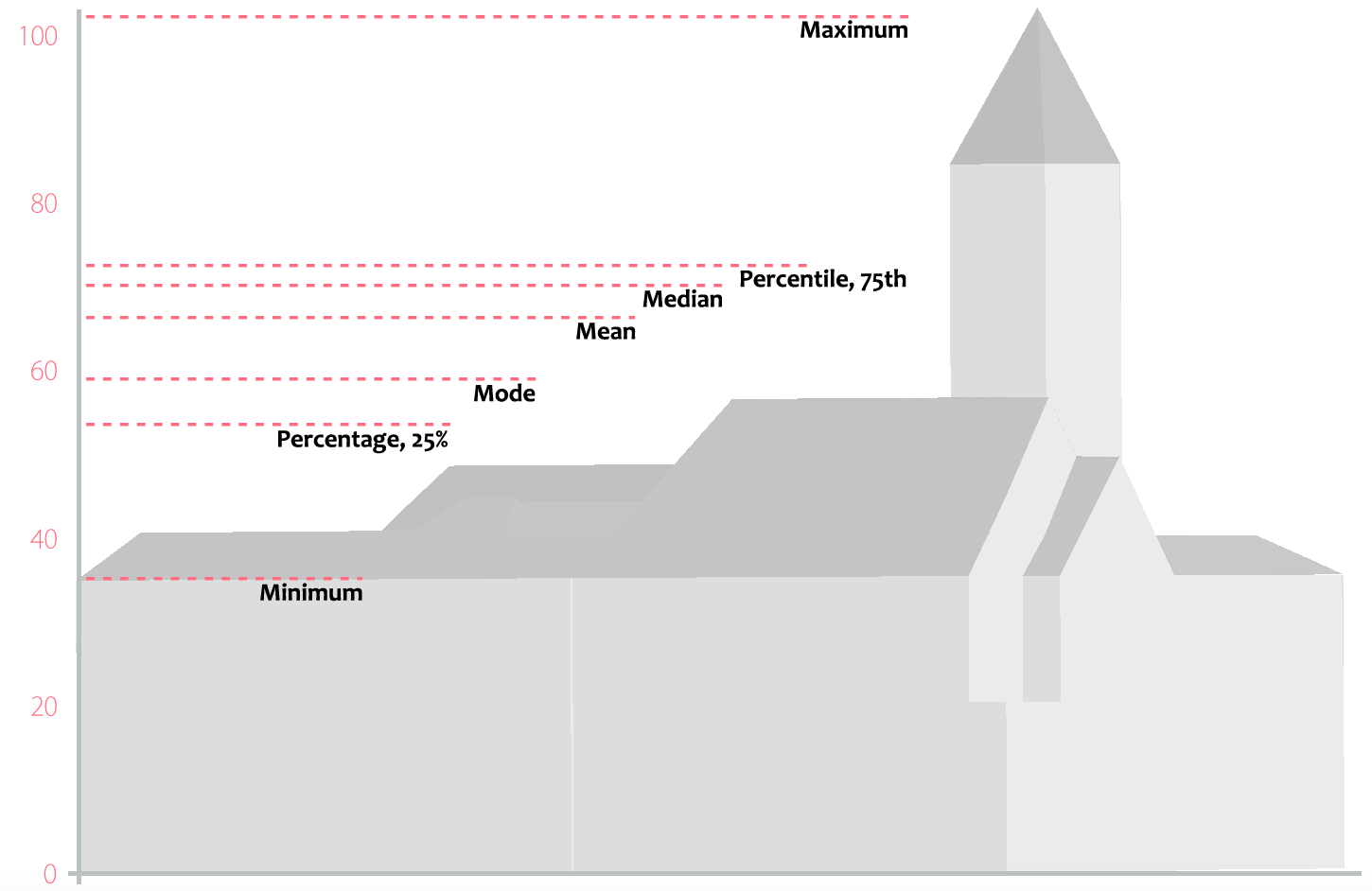
- What are the best generalisation statistics for summarising, quantifying and evaluating the generalisation results? How are they balanced for different applications?
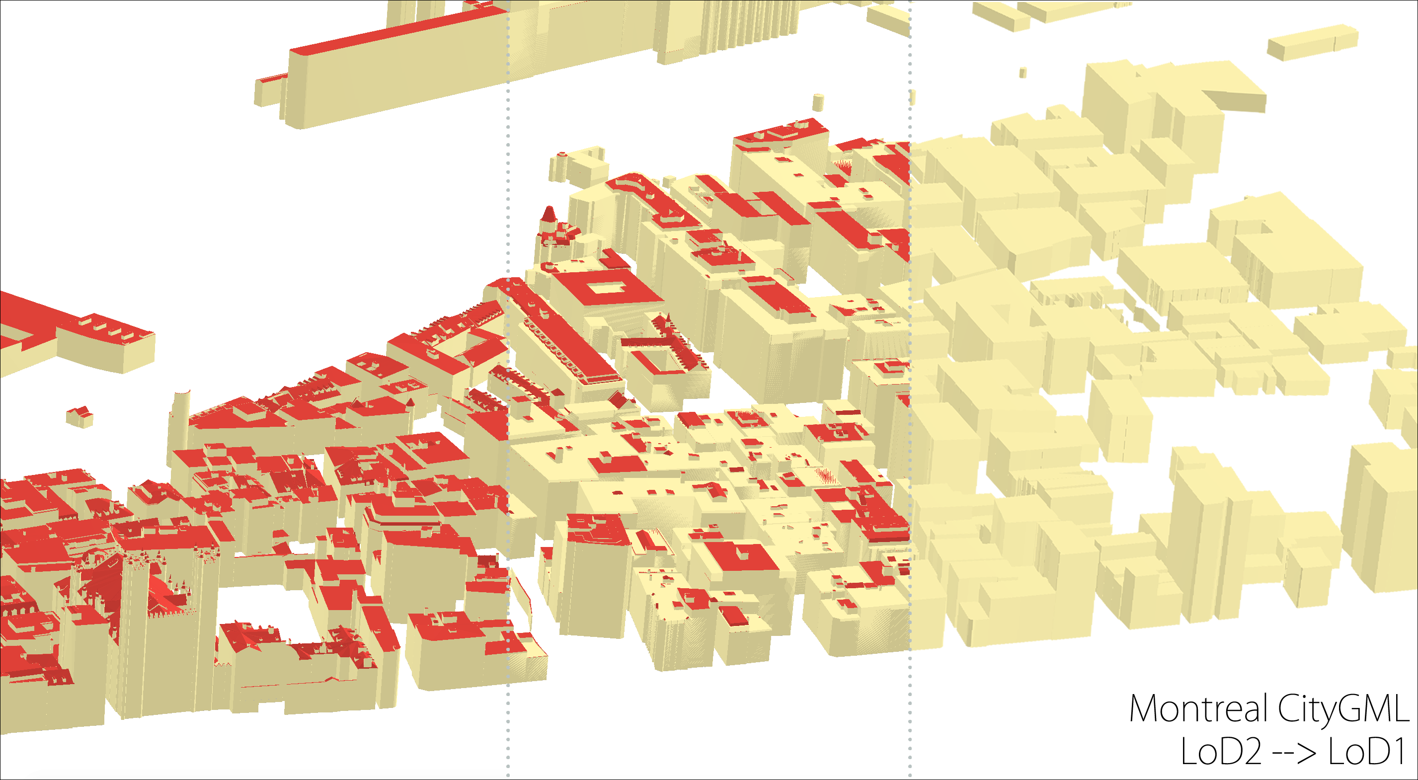
- How is generalisation different between different LoD groups, e.g. LoD3 to LoD2 vs. LoD2 to LoD1?
- How do generalisation approaches differ between buildings and roads?
- How can buildings and roads be generalised to ensure they still fit with an underlying terrain?
- What 3D city model specific attributes are currently missing in metadata standards that are crucial for maintaining generalisation lineage?
- How can metadata generation be automated, stored and updated as a result of generalisation processes?
Current Work
Vertical Reference
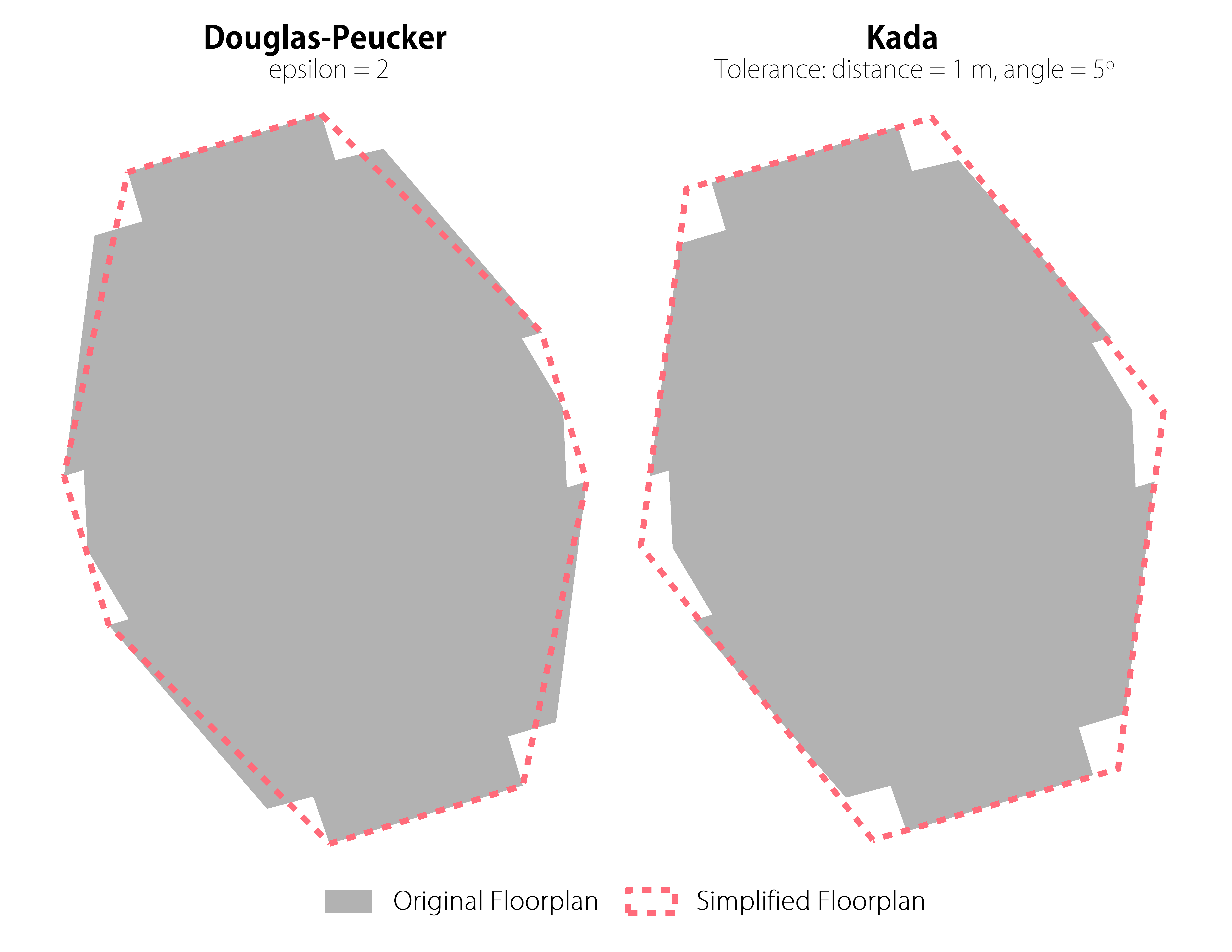
Floor Plan
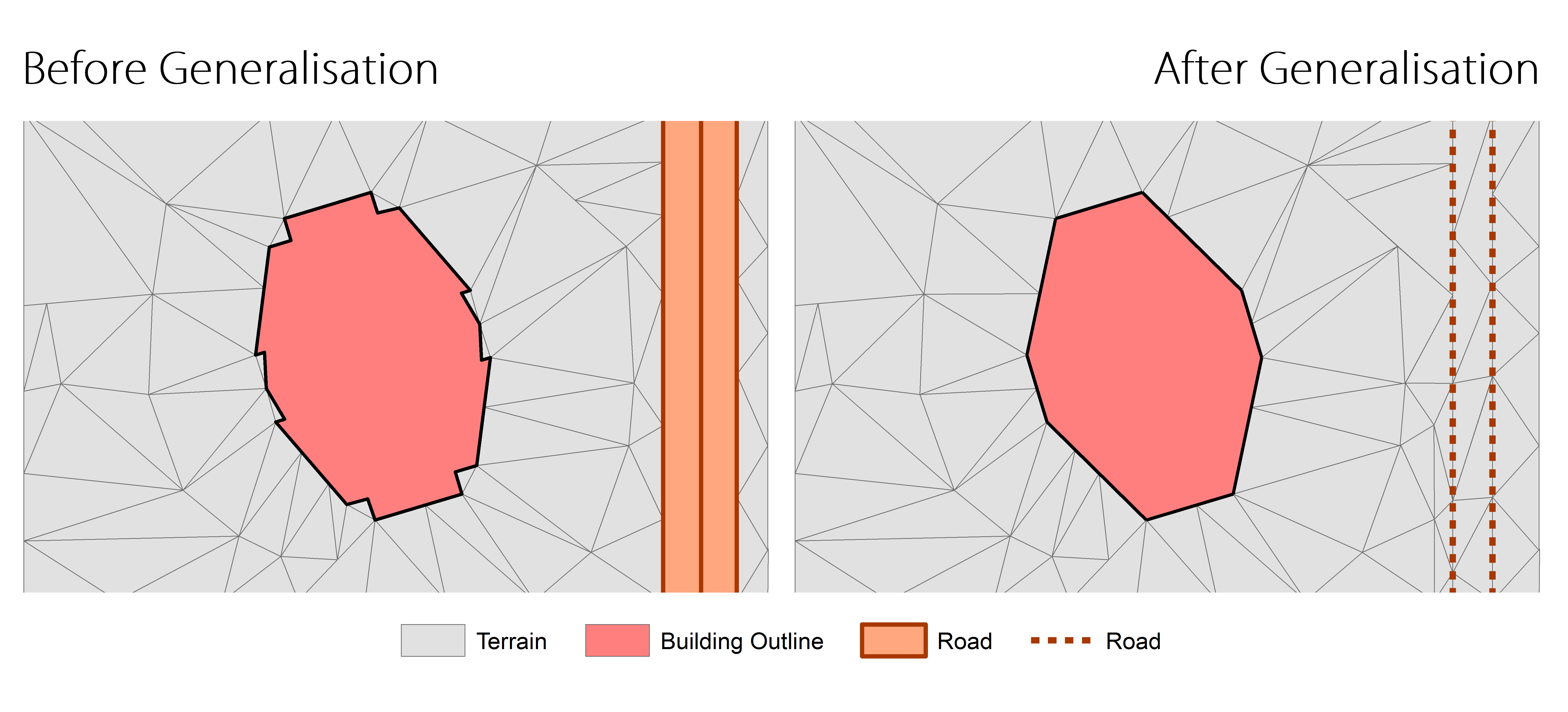
Harmonised Generalisation
Activities
- 01 Aug 2022 Published paper: "3D building metrics for urban morphology"
- 11 Mar 2022 Presented "3D Building Metrics for Urban Morphology" at the Urban Analytics Lab Seminar Series at the National University of Singapore
- 22 Feb 2022 Published paper: "From road centrelines to carriageways—A reconstruction algorithm"
- 02 Nov 2021 Awarded the Geospatial World Excellence Award at GWF 2021 for developing the 3D BAG platform.
- 14 Oct 2021 Awarded the Outstanding paper: 3D Processing & Visualization title in 3D Geoinfo 2021, for participating in Clara et al's publication 'The impact of level of detail in 3D city models for CFD-based wind flow simulations'.
- 19 Nov 2020 Published paper: "Built Environmental Correlates of Cycling Accidents Involving Fatalities and Serious Injuries in London, UK"
- 10 Sep 2020 Presented paper: "CityJSON + web = ninja" at the 2020 3D GeoInfo Conference.
- 03 Jul 2020 Utilised as one of the references for the Dutch network modelling proposal for roads, "Conceptueel model netwerken" by the Ministerie van Infrastructuur en Waterstaat
- 16 Jun 2020 Published paper: "Flood damage cost estimation in 3D based on an indicator modelling framework"
- 14 May 2020 Invited talk '3D Gebouw Reconstructie uit BAG+AHN3' by Ravi on De Grote Geo Show.
- 30 Apr 2020 Invited talk 'wat doet TU3D?' by Hugo on De Grote Geo Show.
- 18 Mar 2020 Article published in the GIM International Magazine: Business Guide 2020.
- 02 Dec 2019 Anna Labetski presented about "open" geospatial standards at the EuroSDR - AMS GeoBIM benchmark workshop.
- 18 Oct 2019 Anna Labetski completed a 2 month research visit at the Singapore Land Authority with the Survey and Geomatics Division.
- 27 Sep 2019 Presented paper: "An Improved LOD Framework for the Terrains in 3D City Models" at the 2019 3D GeoInfo Conference.
- 27 Sep 2019 Presented paper: "A Survey on the Adoption of GIS Data and Standards in Urban Application Domains" at the 2019 3D GeoInfo Conference.
- 27 Sep 2019 Presented paper: "A Data Structure to Incorporate Versioning in 3D City Models" at the 2019 3D GeoInfo Conference.
- 27 Sep 2019 Awarded Best Paper Award (Runner-up) for the paper: "A Data Structure to Incorporate Versioning in 3D City Models" at the 2019 3D GeoInfo Conference.
- 07 Aug 2019 The first stable version of our CityJSON loader plugin for QGIS is officially accepted in the QGIS plugins' repository.
- 15 Jul 2019 Published paper: "The LandInfra standard and its role in solving the BIM-GIS quagmire"
- 17 Jun 2019 Published paper: "CityJSON: a compact and easy-to-use encoding of the CityGML data model."
- 29 May 2019 Published paper: "Harmonising the OGC Standards for the Built Environment: A CityGML Extension for LandInfra"
- 08 Mar 2019 Anna Labetski completed a 1 week research visit at University College London
- 22 Jan 2019 Invited talk 'Improving the usability of 3D city models' by Hugo at the Universität Münster GI-Forum
- 30 Nov 2018 Published paper: "A metadata ADE for CityGML"
- 02 Oct 2018 Organised the 2018 3D GeoInfo Conference in Delft.
- 01 Oct 2018 Presented paper: "A proposal for an improved transportation model in CityGML" in the 2018 3D GeoInfo Conference
- 30 Sep 2018 Organised the pre-conference workshop "Automated reconstruction of 3D City Models and using them in urban applications" for the 2018 3D GeoInfo Conference in Delft.
- 30 Sep 2018 Developed an up-to-date 3D building service covering whole of the Netherlands 3D BAG. Published via 4TU Data Centre
- 30 Aug 2018 Keynote at the GIScience conference in Melbourne.
- 24 Aug 2018 Open lecture at the National University of Singapore..
- 21 Mar 2018 Invited talk 'CityJSON---A JSON-based implementation of the CityGML data model' by Hugo at the OGC meeting (Orléans, France)
- 15 Mar 2018 (Co)organised a successfull international symposium on Point Clouds Processing.
- 23 Feb 2018 Published paper: "Val3dity: validation of 3D GIS primitives according to the international standards".
- 30 Dec 2017 Jantien Stoter interviewed for ten years anniversary ERC ERC Anniversary interview.
- 27 Nov 2017 Invited talk 'CityGML (as an encoding) is dood, lang leven CityJSON!' by Hugo at the the Geonovum Springplank (Amersfoort, the Netherlands)
- 24 Nov 2017 Invited presentation at the GeoBIM conference in Amsterdam.
- 02 Nov 2017 Presented our reseach subject to the NCG Symposium at the TU Delft.
- 02 Nov 2017 Jantien Stoter nominated for personal Geo Prestige Award Professional Geo Prestige Professional Award.
- 11 Sep 2017 Anna Labetski successfully passed her Go/NoGo meeting after submitting her research proposal.
- 23 Jun 2017 Anna Labetski completed a 1 week research visit at the Technische Universität München
- 07 Jun 2017 Anna Labetski and Stelios Vitalis participated in the TU Delft Research Exhibit 2017.
- 30 Mar 2017 We co-organised the EuroSDR workshop on economic value of 3D Geoinformation at ICGC Barcelona
- 24 Mar 2017 Presented our research in the PhD symposium with the Geomatics department of TU Munchen.
- 17 Mar 2017 We organised the technial meeting of the worldwide standardisation organisation of geographical information (OGC) in Delft (200+ participants) OGC TC Meeting Delft
- 15 Mar 2017 We organised the Symposium 3D urban modelling with Prof Thomas H. Kolbe
- 02 Feb 2017 The project was shown during the Research Exhibition of Delft University of Technology (175th anniversary).
- 02 Feb 2017 Jantien (PI) participated in working visit of Dutch delegation (industry, academia and government) to London.
- 13 Jan 2017 Presented paper: "Generalising 3D Buildings from LoD2 to LoD1" at GISRUK 2017 in Manchester, UK.
- 25 Nov 2016 We organised the National 3D symposium (150+ participants)
- 01 Sep 2016 Jantien appointed as Principal Investigator at Amsterdam Institute of Advanced Matropolitan Solutions
- 01 Sep 2016 Anna Labetski officially started working on UMnD.