

Frequently asked questions
- Why should I participate?
- How many tasks is it necessary to perform for participating?
- How much time does it take to perform the tasks and deliver results?
- How will the delivered data and documents be used?
- What are the needed steps to participate?
- Can I participate if I have some potential conflict of interest?
- Can I test a software/tool that was already tested or is being tested?
- What should I do if my tests are not successful?
- Is it possible to participate testing a software and/or making a task different from the ones declared in the first registration?
- How do I have to do the test and deliver results?
- Can I complete the online forms without an internet connection?
- Why should I also attach the word format of the results template?
- In filling the results templates while preforming the task, is it possible to refer to web materials already answering the question (e.g. describing needed procedures or settings, and so on)?
- Once the results in the online forms are submitted, is it possible to modify the answers?
- Once the results in the online forms are submitted, is it possible to see them again?
- What are geographic coordinate systems?
- What are projected coordinate systems?
- What are vertical coordinate systems?
- What is the EPSG code?
- IFC certification
- If you didn’t find the information you are looking for…
Questions about participation
Why should I participate?
-
To contribute to define a useful framework of the technical solutions for geo- and BIM activities employing open standards;
-
Participants delivering suitable results can be cited in the benchmark website;
-
The scientific material regarding the used procedures/tools (papers, reports, web resources, open repositories…) will be linked in the benchmark website;
-
At least one scientific publication co-authored by both the benchmark proponents and participants will be written.
How many tasks is it necessary to perform for participating?
You can choose 1 to all the proposed tasks. Each task is independent from the others, so, even 1 is sufficient.
How much time does it take to perform the tasks and deliver results?
The needed time is, approximately, between a couple of hours and one/two working days, also considering the waiting time for computer response in case of heavy files. It also depends on the level of confidence you have with the tested software.
How will the delivered data and documents be used?
The delivered results will be used (anonymously) to:
- Perform the analysis and activities foreseen by this project, i.e.:
-
filling of a list of tools for geo- and BIM models management in CityGML and IFC to be used as a framework for involved or interested operator;
-
identification of common issues in software or open standards and encourage their improvement;
-
contribution to the discussion about open standards, geoinformation, BIM, used software tools, models georeferencing, GeoBIM;
-
publication of results in scientific papers and communications;
-
in-depth insight during the project meeting and the GeoBIM winter school;
if you want to have more details, read the complete description of the project in this website.
-
Be reference for related research activities;
-
They will be published (anonymously) as open data together with the other benchmark results for further research activities.
To be sure that the participants agree with this use of the results, they are asked to check some declarations at the end of the online results templates they will deliver.
What are the needed steps to participate?
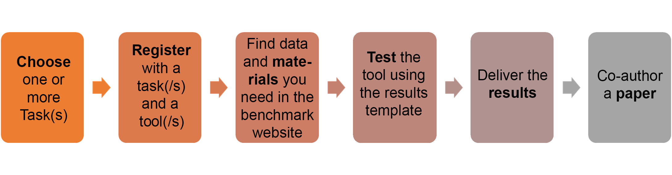
Read the information in the website, to understand the project and the task.
Before beginning, participants should read, in particular:
- The description of the task they will perform in the task description section;
- The description of the data they will use in the data description section;
- The list of tested software (or under test), to suitably choose which tool to test. It is, however, possible to test the same software more than once (see specific FAQ).
- These FAQs
- The word-format of the results template for the chosen task, in order to have an overall view of the task.
Can I participate if I have some potential conflict of interest?
If you have some possible conflict of interest (e.g. you work for a software house, you are the developer of a new software, you are very involved with open standard development) you can participate in the benchmark, just declaring it in the initial part of the forms. Moreover, your contribution as an expert is welcome.
You are just asked to give as many details as possible about procedures and settings of the tested workflows and tools, in order to enable their easy repeatability, besides demonstrating their effectiveness.
Moreover, obviously, you must answer honestly to the questions.
Can I test a software/tool that was already tested or is being tested?
You can see from the software section of the website the list of software tested or being tested.
Our aim is the test of the highest number of tools, in order to build the widest possible framework of technical solutions for the benchmark tasks, as a useful reference for the whole community. Therefore, participants are invited to keep this in mind when choosing the software to be tested.
However, it is also possible to test the same software or tool more than once. It can be useful to check repeatability and, eventually, testing different kinds of customisation possibilities, especially concerning the most flexible tools.
What should I do if my tests are not successful?
If issues prevent any task to be completed until the end, you can anyway deliver the results you obtained, giving detailed descriptions of the found problems.
Is it possible to participate testing a software and/or making a task different from the ones declared in the first registration?
Yes, eventually, it is not a problem. But, if possible, we wil be grateful if you communicate the change through e-mail (f.noardo@tudelft.nl) as soon as you decide.
How do I have to do the test and deliver results?
Results templates are provided for each task in order to guide the test in each passage and deliver detailed results. They have the format of online forms, where doc/pdf/jpg files can be attached in specific sections, when required. The results template in word format is also available, to have an overview on the specific task, to be used as a guideline in making the test, and, eventually, to be attached in the case it is necessary to deliver more detailed descriptions.
Can I complete the online forms without an internet connection?
Unfortunately, there’s no “offline mode” with Typeform (which is used for building the results templates). It’s designed to work only with an internet connection, which you need to load the typeform, and also to submit responses.
If someone starts completing a typeform but loses their internet connection, they can click the Submit button, but a message will appear saying results cannot be submitted, and to not close the page. The typeform will keep trying until the internet connection returns, as long as the browser tab remains open.
Why should I also attach the word format of the results template?
Only the submission of the online formas is mandatory. It is not compulsory to add other formats, just do it if you have any doubt about the given answers in the online form (e.g. no space enough for the descriptions or screenshots, no space for other needed details, and similar issues).
In filling the results templates while preforming the task, is it possible to refer to web materials already answering the question (e.g. describing needed procedures or settings, and so on)?
Yes, it is possible. Those should be eventually integrated with any further needed detail.
Once the results in the online forms are submitted, is it possible to modify the answers?
Unfortunately not. In the case this is necessary, you can e-mail the organisers to report the needed changes.
Once the results in the online forms are submitted, is it possible to see them again?
Yes, once you submit the form, you will receive an e-mail with the link to the following form and the answers you have submitted.
Glossary and other definitions
What are geographic coordinate systems?
A geographic coordinate system (GCS) defines a location on the Earth surface through coordinates describing the angles measured from the earth’s center to a point on the earth’s surface. An angular unit of measure, a prime meridian, and a datum (ellipsoid) describe a GCS.
Latitude is the vertical angle from the centre of the Earth.
Lines of equal latitude on the reference ellipsoid are parallels.
The 0 latitude parallel is the equator (line of latitude midway between the poles).
Longitude is the horizontal angle from the centre of the Earth.
Lines of equal longitude on the reference ellipsoid are meridians.
The 0 longitude (prime) meridian, for most geographic coordinate systems, passes through Greenwich, England.
Possible references for an extended description can be found, among many other resources, in the QGIS online documentation, and in the ArcGIS online documentation
What are projected coordinate systems?
A projected coordinate system relates a 2D location on the Earth surface to a location described as 2D coordinates (distances) on a Cartesian plane, once defined a measure unit, an origin, a projection system.
A projection system is the used method for drawing the objects on a curved surface (namely, the ellipsoid surface) on a planar surface.
Possible references for an extended description can be found, among many other resources, in the QGIS online documentation, and in the ArcGIS online documentation
What are vertical coordinate systems?
A vertical coordinate system defines the origin for height or depth values with reference to a geoid (model of the Earth considering the surface having the same effective potential).
Mean sea level is used as the zero level for height values.
A linear unit of measure is used.
Possible references for an extended description can be found, among many other resources, in the QGIS online documentation, and in the ArcGIS online documentation.
For 3D data, combined horizontal and vertical reference systems are often used.
What is the EPSG code?
It is a code identifying the existing reference systems and pointing at the resources describing their parameters. You can read more it here.
IFC certification
The IFC certification by buildingSMART is described in the specific section of the buildingSMART website. In that page you can read information about the certification programs, which depends on the considered IFC version and Model View Definition. For example, a list of software under certification process for the IFC certification program ‘IFC2x3 CV V2.0’ can be read at this link.
If you didn’t find the information you are looking for…
You can contact us through e-mail at f.noardo@tudelft.nl
Important dates and next steps
March 2019
- Complete materials available
- Start of declaration of interest from participants
July 8th, 2019
- GeoBIM benchmark meeting with participants and proponents
October 31st, 2019
- Deadline for data processing and benchmark answer submission
December 2nd-3rd, 2019
Team
Francesca NoardoKen Arroyo Ohori
Jantien Stoter
Filip Biljecki
Claire Ellul
Lars Harrie
Thomas Krijnen
Giorgio Agugiaro
Margarita Kokla