Postdoc or Junior Researcher 'Automated 3D building reconstruction from aerial photography’
Postdoc or Junior Researcher ‘Automated 3D building reconstruction from aerial photography’
We are looking for a researcher at Postdoc or MSc level to improve and extend our algorithms for automated large scale 3D building reconstruction to benefit from image based height data acquired using eg. photogrammetry.
Job description
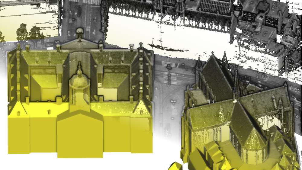
In our Urban Modelling in Higher dimensions project, fubded by the European Research Council, we developed a technique to automatically reconstruct detailed 3D models of buildings from aerial LiDAR data and building footprints. The solution has been applied to generate 3D models for all 10 million buildings in The Netherlands at Levels of Detail 1.2, 1.3 and 2.2. This 3D BAG dataset is available as open data and it is widely adopted across different industries and organisations. See also this paper.
Recently the European Reserach Council awarded our proposal to further develop and extend our 3D BAG service that generates and provides 3D building models for very large areas. The aim of this Proof of Concept project is to expand the prototype as well as the countrywide 3D dataset as a long-term, reliable, up-to-date and user-friendly service.
Our 3D Geoinformation research group has an open 1-year position for a researcher (Postdoc or MSc level, depending on the experiences of the selected candidate) to specifically address the project tasks to 1) enhance our method to take advantage of a wider range of input sources, specifically height data extracted from, or represented as, images acquired using photogrammetry (in addition to the currently supported LiDAR point clouds) and 2) research how to smartly fill in no-data gaps in the input elevation data caused by occlusion effects during acquisition using eg. deep learning.
Research group
The Geoinformation research group, Section Urban Data Science, Delft University of Technology focuses on the technologies underpinning geographical information systems (GIS), and aims at designing, developing, and implementing better systems to model 3D cities, buildings and landscapes. It is a a multidisciplinary group of around 25 people, including computer scientists, geomatics engineers, and geographers. The group has a history of successful collaborations with the industry and the government: its research has led to open source software, standards, 3D open data and patents for the management of 3D geographic information and Building Information Models. The researcher will work in close collaboration with 3DGI, the partner organisation in the Proof of Concept project responsible for the update and maintenance of the 3D BAG service.
Job requirements
Applicants should:
- hold an MSc (for early stage researcher; software developer) or a PhD degree (for senior researcher) in remote sensing/photogrammetry, geoinformatics/geomatics, computer science, applied mathematics, or in a related discipline.
- have experience in photogrammetry, feature detection from images, machine learning, 3D modelling and/or computational geometry, preferably from a programming perspective.
- have good software development skills. Experience with C++ is beneficial.
- have a good command of English (oral and written)
- have an affinity with working in multi‐disciplinary teams in an international oriented environment.
What we offer
Salary scale 10 or 11; depending on the working experience and education level of the candidate. The TU Delft offers a customisable compensation package, a discount on health insurance and sport memberships, and a monthly work costs contribution. Flexible work schedules can be arranged. For international applicants we offer the Coming to Delft Service and Partner Career Advice to assist you with your relocation. An International Children’s Centre offers childcare and there is an international primary school.
How to apply
You can apply via this webpage.
Your application should contain:
- A letter of application and a detailed CV.
- A list of examples that prove your previous work related to the position (projects, experience, software, research, publications).
- The names of two references, with contact information (letters not required at this stage).
Please note:
- You can only apply online; applications sent by email and/or post will not be processed
- Incomplete applications will not be processed
- Acquisition in response to this vacancy is not appreciated
For more information about this position, please contact directly Dr Ravi Peters (r.y.peters@tudelft.nl) or Prof dr Jantien Stoter (j.e.stoter@tudelft.nl).