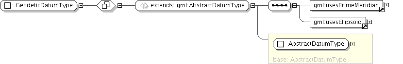
Documentation for fieldgml

Complex Type: GeodeticDatumType

[Table of contents]

Super-types: gml:DefinitionType < AbstractDatumBaseType (by restriction) < AbstractDatumType (by extension) < GeodeticDatumType (by extension)
Sub-types: None
Name GeodeticDatumType
Abstract no
Documentation A geodetic datum defines the precise location and orientation in 3-dimensional space of a defined ellipsoid (or sphere) that approximates the shape of the earth, or of a Cartesian coordinate system centered in this ellipsoid (or sphere).
XML Instance Representation
<...
gml:id="[1]">
<gml:datumName> ... </gml:datumName> [1]
<gml:datumID> ... </gml:datumID> [0..*]

'Set of alternative identifications of this datum. The first datumID, if any, is normally the primary identification code, and any others are aliases.'

<gml:remarks> ... </gml:remarks> [0..1]

'Comments on this reference system, including source information.'

<gml:anchorPoint> ... </gml:anchorPoint> [0..1]
<gml:validArea> ... </gml:validArea> [0..1]
<gml:scope> ... </gml:scope> [0..1]
</...>
Diagram
Schema Component Representation
<complexType name="GeodeticDatumType">
<complexContent>
<extension base=" gml:AbstractDatumType ">
<sequence>
<element ref=" gml:usesPrimeMeridian "/>
<element ref=" gml:usesEllipsoid "/>
</sequence>
</extension>
</complexContent>
</complexType>