Thesis starting April 2023

Christos Chontos

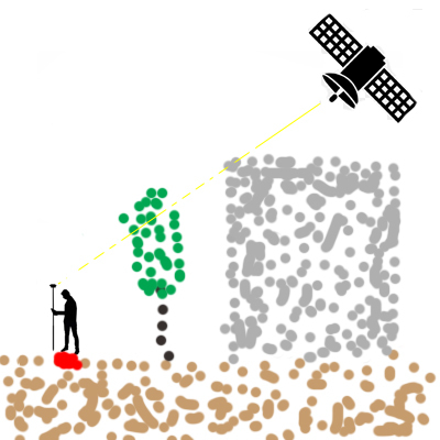
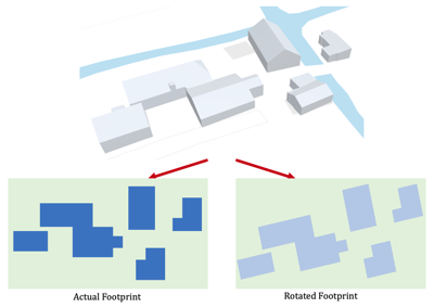
While reconstructing urban environments, the accuracy of our model is strongly related with the quality of the input data. Their initial type for this process is the footprints of the buildings, which are typically used to raise them, either through manual or automated methods. However, these data could be biased and when we perform a Computational Fluid Dynamic simulation (CFD), could have impact on our results. In our case, real-world building footprints will be used to define these biases with the uncertainty of raw data. Additionally, the probability approach for representing and quantifying this uncertainty will be examined. The CEDVAL database is an example of a canonical case for the simulations, in which the building footprints could be perturbed based on mean from point cloud data, in a deterministic way (rotation and displacement). A CFD simulation on such a canonical case would typically involve the following steps: 1) Preparation of our geometry, 2)Generation of the mesh, 3) Boundary conditions (fluid properties, inlet velocity and other relevant parameters), 4) Numerical solution by solving a system of algebraic equations and 5) Post-processing, like visualization of the flow patterns and comparing the simulation results with the experimental data from the CEDVAL database. The data that will be compared are flow velocity, pressure, turbulent kinetic energy, dissipation rate and turbulent viscosity. The effects will be examined across multiple wind directions.

Supervisors: Clara Garcia-Sanchez + Ivan Pađen

Andra Irina Gheorghiu

Global Navigation Satellite Systems is a spatial data acquisition technique, mostly used in fields such as land surveying. One of the main components of this techniques is the satellite visibility, which refers to the connection between the satellite and the ground receiver. It is well known that the results GNSS positioning systems are often unreliable in urban areas due to the dense coverage of obstacles. Such obstacles can include buildings, trees, topographic details etc. These obstacles can obstruct and reflect the signals coming from the satellites to the ground receivers, such as smartphones, which affect the quality of the performance of the GNSS service. The results of the analysis of the behavior of these signals in the urban environment can help simple users of GNSS positioning systems understand why and in which areas of the cities the satellite signals are the weakest or non-existent at all. This research can also be used in the future to point out the weak aspects of the satellite constellations and then improve them. This research will be focused on implementing a strategy, similar to that of ray tracing or shadow matching, to analyze the obstruction of the lines of sight from satellites, using different locations in the point cloud sample. For this study, the ANH4 set of point clouds will be used. The GNSS study part will consist of the constellation of satellites, taking into consideration details such as the study of their orbits, and a ground receiver.

Supervisors: Edward Verbree + Martijn Meijers

Pam Sterkman

Point clouds are widely used in a variety of fields nowadays. This rich data resource has multiple functions for different disciplines. The company Van Oord uses Light Detection and Ranging (LIDAR) data of drones to generate point clouds for several purposes within their projects, such as volumetric calculations, anomaly detection, and distance measurements.

Despite the fact that point clouds are used for a variety of applications, the data is often underused. A point cloud can namely function as an extensive data resource with potential use cases that are not explored yet. This comes together in the concept of smart point clouds (SPC) (Poux et al., 2016). It sees the explorative value of point clouds through the addition of semantics, and integration of information flows from different directions. The inclusion of human observation can thus be integrated into the semantics of the point cloud.

This research will therefore explore the possibilities of SPC by integrating the knowledge of present disciplines within Van Oord. Van Oord has engineers operating in the fields of dredging, offshore (wind), and infrastructure. This means that a variety of expertise is available within the company, which integration can be beneficial for identifying new insights into the current use of point cloud data. The aim of this thesis is to optimize the usage of point clouds acquired through LIDAR data via drones.

Supervisors: Edward Verbree + Martijn Meijers

Michaja Andrea van Capel

Land Surface Temperature (LST) of a specific location is affected by different parameters, such as the urban design, along with land cover and sub-surface parameters. Therefore LST can be a proper indicator for understanding the thermal behavior of different urban climate zones. This thesis aims to classify urban Local Climate Zones (LCZ’s) using deep learning and spatio-temporal thermal imagery. The use of an integrated RNN-CNN deep learning methodology is proposed to identify both the spatial and temporal characteristics of the thermal behavior of LCZ’s in an urban environment. By using high frequency temporal LST data, this research can provide a more comprehensive understanding of the thermal behavior of different LCZ’s over time. Training data of different urban environments will be taken into consideration, to ensure that the deep learning methodology is versatile.

Supervisors: Azarakhsh Rafiee + Not yet decided