Thesis starting April 2022

Carolin Bachert
Adaption of the EnergyADE to the new CityGML 3.0 standard

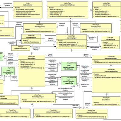
The new CityGML 3.0 standard was officially released as a conceptual model in 2021. Among other changes, it includes a revised space concept with the distinction in AbstractSpace, AbstractSpaceBoundary, OccupiedSpace and UnoccupiedSpace. Furthermore, it offers new possibilities to store time-dependent attributes through the Dynamizer and Versioning modules. In the existing Energy Application Domain Extension for CityGML 2.0 similar concepts have to be additionally modelled, for example to describe ThermalZones and ThermalBoundaries. Therefore, I am going to explore how the Energy ADE can be mapped to the new standard, i.e. which classes, attributes, and relations became redundant and which of them are still needed. The conceptual mapping will then be implemented by creating an updated UML diagram for the Energy ADE together with its according XML Schema file. CityGML 3.0’s new ADE Hook mechanism will play an important role here; for me to find a way to incorporate the additional information to the core model. The updated ADE will finally be tested through generated sample data, with the aim to convert CityGML 2.0 + Energy ADE data to CityGML 3.0 + (updated) Energy ADE.

Supervisors: Giorgio Agugiaro + Camilo León Sánchez

Daniël James Dobson
{"Building floor count determination with images"=>"A Deep Learning approach."}

Accurately knowing the number of floors of a building is an important factor when assessing the built environment. Building floor count can help with a wide range of subjects such as building energy demand models, flood response plans, housing market studies and so on. The problem is that there is no global (open) dataset containing this information. Examples of datasets that could contain building floor count information (implicitly), are point clouds or cadastral data. These are expensive, infrequently updated, and/or closed. Instead, pictures are a relatively inexpensive, easily updateable and available data source, existing already at large scale (eg Google Street View, Mapillary). However, although inferring higher lever semantics (eg building floor count) from images is trivial for a human, for a machine it is not. Prior work has been done on successfully extracting lower level building semantics (eg doors, windows, balconies) from images with a deep convolutional neural network. The objective is to extend this research and develop an end-to-end pipeline to accurately determine the building floor count from lower level semantics. How should the semantics (eg windows) be processed further? What type of spatial clustering is most effective in building floor count? What (pre)processing techniques increase the performance of the proposed method? These are initial questions that arise in solving accurate building floor count determination with deep learning.

Supervisors: Ken Arroyo Ohori + Nail Ibrahimli

Haoyang Dong
Correcting global elevation models for canopy and infrastructure using Machine Learning

Accurate elevation data are essential for many applications in geoscience. Unfortunately, most digital elevation models (DEMs) are Digital Surface Models (DSMs) rather than Digital Terrain Models (DTMs), in which the data of vegetation and buildings will cause systematical errors. Current methods of converting DSMs to (pseudo)DTMs such as MERIT DEM, FABDEM, and CoastalDEM are either uncompleted or vague about the exact methods used and with results that contain artifacts.

This project aims to produce a (pseudo)DTM from a DSM. The main two steps of the methodology:

  1. Surface classification and removing non-ground pixels using machine learning
  2. Interpolating the removed pixels from ground surroundings using traditional methods

Both the AHN4 datasets (resolution at 0.5m and 5m) and global DEMs (resolution at 30m) are considered to be used. The evaluation of classification in this method can be done with a proper train-test split on AHN4 datasets. Furthermore, the comparison of the results between this method and other models mentioned above will be made on global DEMs. Resampling and discussion on the effects of the resolution are also parts of this project.

Applications that need the correct representation of the terrain like flood simulation and further research on correcting DEMs with machine learning will benefit from the project.

Supervisors: Maarten Pronk + Hugo Ledoux

Lisa Geers
Automatic real time detection of fisher boats in Natura 2000 areas with the use of drones

Natura 2000 is a European network of protected areas with the purpose to protect the habitat of numerous species. For this reason fishing is constrained in marine protected areas. Monitoring the compliance of fisher boats to these rules is done by the Dutch NVWA and is very labour intensive, as surveyors need to sail around in boats to check fishers. The NVWA wants to change this method by using drones to monitor these fishing boats. This is still a challenge, because fishing boats as well as fishing activity need to be automatically detected on the drone footage. Moreover, the exact location of the boats needs to be determined to see if they are fishing in restricted areas. In addition, these objectives need to be carried out in real time for the surveyor to be able to catch law-breaking fishers in the act. This thesis aims to find a method to detect and localise active fishing boats in real time. This will be done with the use of Esri’s GeoAI software, collected drone footage from the Dutch NVWA and other open spatial data. The following objectives will be researched: -How to detect fishing boats on drone footage and determine if they are fishing. -How to derive the exact location of boats from drone footage. -How to carry out these objectives in real time.

Supervisors: Martijn Meijers + Azarakhsh Rafiee

Lisa Keurentjes
Automatic repair of 3D city models

To tackle our complex world, we tend to make cities “smarter”, by using simulations from various disciplines, like for example wind field or flood simulations. These simulations and analysis have become essential tools for decision making in urban planning and analytics.

High data quality 3D city models serve as reliable representation of the real world objects, seeing the high-quality information and solid spatial visibility they offer. To validate the quality of the date and achieve interoperability, the ISO 19100 series standards were created. But there are just too many different fields where 3D data can be exploited to conclude all validation rules for every field. For example typical extra requirements for wind simulation software include: no small features, edges, and gaps between buildings. Sadly a significant amount of 3D city models is not considered valid to the standards above. This hinders the further analyzing or processing of these models. Since manual repair of 3D City models is very time consuming and prone to errors, automatic repair methods are highly desirable. Therefore the objective of this thesis will be to develop a software framework as proof-of-concept for automatic repair of 3D city models. The software will repair errors that users choose, so that the models fulfill basic requirements and requirements for specific use cases. Also the Software will be designed in such a way that it could be extended with more repair options.

Supervisors: Hugo ledoux + Ivan Pađen

Pinelopi Eirini Kountouri
Analyzing the effects of level-of-details on the pollutant dispersion in real urban environments

With the increase of urbanization process, more than 50% of the world population live in urban environments, where traffic, industry and domestic pollution pose a high health risk for people. The level of pollution in urban canyons is strongly affected by the building’s layout and city’s organization. Thus, the investigation of wind around buildings and passive scalar distributions is crucial for improving the urban environment, by addressing air pollutant diffusion, natural ventilation and pedestrian comfort. To achieve this, wind flow analysis is required, based on advanced techniques. One of the most common methods used concerning fluid flow is Computational Fluid Dynamics (CFD). CFD simulations of fluid flow and mass transfer require numerical solution of Navier-Stokes equation together with continuity equation. Finally, in the current thesis we will study the Stanford test case to investigate the impact of the level-of-details of real urban environment in results of CFD simulations. Specifically, this research will be focused on testing and applying a wind analysis simulation implementing in different LoDs as well as to build a dispersion model within this work flow. The final outcome will be compared in the end with real-world measurements. Having this goal, the current thesis will answer the following main research question: What’s the impact of different LoDs of the buildings for the pollutant dispersion from different sources around an urban environment?

Supervisors: Clara García-Sánchez + Ivan Pađen

Katrin Meschin
Forest structure estimation of boreal and mixed forest from ICESat-2 radiometric profile

Forests play a crucial role in Earth’s carbon cycle and the global climate. Therefore, understanding forest structure on a global scale is important in environmental research. Ice, Cloud, and land Elevation Satellite (ICESat-2) uses photon counting and is tuned for studying polar regions. However, it also has potential to be used for measuring the structural characteristics of forests at large scales. By using radiometry, the number of signal photons detected per outgoing laser shots, the change in the returns has been shown to vary for different forest types. Neuenschwander et al. (2022) developed an ICESat-2 radiometric profiles for three general forest types which can be used for calculating vegetation structure. However, research for using such radiometric profiles for extracting forest structural information and canopy cover is still in under development. This thesis aims to undertake exploratory analysis on using ICESat-2 data and the radiometric profiles derived to extract forest structural information. The study area is Estonia – a country in Northern Europe with both boreal-type coniferous forest as well as temperate mixed forest. The main research question raised is: To what extent can forest structural information, including the canopy cover, of Estonian boreal and mixed forest be determined from the ICESat-2 radiometry? The results will be validated against an aerial full waveform lidar point cloud by Estonian Land Board which covers the entire Estonian territory

Supervisors: Maarten Pronk + Hugo Ledoux

Simon Pena Pereira
Automated rooftop solar panel detection through Convolutional Neural Networks

As one of the main drivers of the greenhouse effect, the energy sector is increasingly shifting towards more renewable and sustainable energy sources to face climate change by reaching policy-made climate targets. A popular option to contribute to this energy transition is the installation of photovoltaic (PV) systems on rooftops. That allows a renewable energy supply by solar PV systems in a decentralized manner. Depending on the country, there exist well to poorly documented registries of active PV systems, which are a hurdle for planning and achieving an efficient energy transition. An approach for providing up-to-date information on installed systems is the automated detection of rooftop solar panels through Convolutional Neural Networks (CNN). The objective is to train and run a CNN model for object detection on aerial images to determine the location and distribution as well as the approximate size of rooftop solar panels for estimations of their electrical power.

Supervisors: Azarakhsh Rafiee + Stef Lhermitte

Guilherme Spinoza Andreo
{"Accessing a successful open geodata ecosystem from a user-centric perspective"=>"A qualitative comparison"}

An open data ecosystem can be defined as a circular, inclusive, sustainable network, in which data is accessible, re-useable, and oriented for the cooperation of its interdependent environment with its users. A well-performing user driven open geodata ecosystem could potentially stimulate citizen participation, innovation, use and re-use of data between users and data suppliers. To understand the status of geoinformation in these ecosystems and to identify the socio-economic benefits of a well-performing one, further research is required into how they can be assessed properly. Using an assessment framework can be a strong instrument to further develop open geodata ecosystems, especially for cities in the early stages of development. Measuring and evaluating the value and success of open geoinformation in relation to user participation in the private, public and educational sectors is still a challenge. What aspects can be used to define the most effective strategy to transition to an open geodata? What are the crucial factors that promote user participation? This thesis aims to develop an assessment framework to provide guidelines for the development of a successful open geodata ecosystem from a user-centric perspective. This framework will include indicators developed through qualitative research by interviewing various user groups and will be used to perform a comparative analysis of local open geodata ecosystems considered to be a best practice for user participation.

Supervisors: Frederika Welle Donker + Stefano Calzatti