Thesis starting September 2021

Irène Apra
3D data integration into a Convolutional Neural Network (CNN) on RGB aerial images to improve the semantic segmentation of roof superstructures on buildings

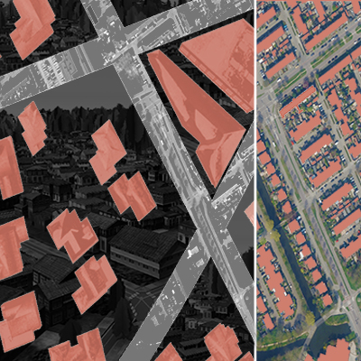
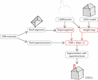
The thesis is written in cooperation with the faculty of mechanical engineering of the Technical University of Munich where a pipeline is being developed at the chair of automotive engineering to assess the PV-potential of buildings in Bavaria. The current state includes two Convolution Neural Networks (CNN) assessing the roof geometrical potential for PV installation. The first network segments a roof into 16 azimuth classes; the second detects installations on the roof, called “superstructures”, as single- or multi-classes (ladder, chimney…). The wider pipeline considers the physical suitability of roofs, as well as the technical and economical potentials for PV installation.

The motivation of the thesis is to improve the geometrical potential assessment of roofs by extending the existing network(s) with 3D data. Despite little research conducted on CNN for RGB-Height (Z) data, it has recently been established that Z information added to a CNN can improve the accuracy for classifying aerial imagery.

Based on these results and the existing work at the chair, we will explore the following question: How can 3D data be best integrated into a CNN for RGB aerial images to improve the semantic segmentation of roof superstructures on buildings? Various types of height data and their combination with the segmentation results of the second network will be explored, as well as their integration to the existing architecture and the evolution of the results accuracy.

Supervisors: Ken Arroyo Ohori + Giorgio Agugiaro

Camilo Cáceres
Automated Semantic Segmentation of Aerial Imagery using Synthetic Data

Automated semantic segmentation of aerial imagery is a complex problem addressed over the past years with deep learning techniques that account for satisfactory results. However, the cost of labeling images for deep learning-based approaches is high, and acquisition of the labeled data is manually expensive.

Currently, in computer vision, most research works focus more on enhancing the training data than improving the models. One of these enhancing methods is the use of synthetic training images, which refer to simulated aerial imagery taken from a virtual world. Compared to real imagery data, synthetic images have several significant advantages, such as simulating different conditions (e.g., lighting, camera positions) and lowering production costs.

Consequently, this thesis aims to create a benchmark to produce synthetic data for aerial image segmentation. We will develop artificial cities with procedural architecture techniques to simulate real-world cities. We will build a tool using existing computer vision techniques to produce training images with pixel-wise semantic segmentation. With the produced synthetic images, we will train a deep learning model to perform semantic segmentation over real-world images (with techniques such as domain adaptation). We will also incorporate features of 3D building to enhance the model further. In the end, the performance of the model will be evaluated using metrics such as accuracy and mIoU (mean Intersection over Union).

Supervisors: Shenglan Du + Jantien Stoter

Ioannis Dardavesis
Indoor localisation in public buildings based on captured images of the ceilings

Nowadays, the evolution of localisation and navigation technologies is vast, aiding towards facilitating users’ guidance in various environments. Landmarks such as high-rise buildings, are of high importance for the users’ guidance in the outdoor environment. Additionally, landmarks can also be used as an affirmation that the user is on the correct route. Concerning indoor landmarks, their lower density and the absence of outstanding elements, may result to easier loss of orientation compared to outdoors. Localisation, combined with an indoor network, can provide information on the current and previous locations of a user. Therefore, localisation may be used in case of emergencies, such as fires, where a civilian has to describe his location to the fire authorities. Consequently, indoor landmarks can be used to transmit this information. This thesis will investigate the reliability of ceilings as indoor landmarks in terms of user guidance. Image matching techniques will be used, based on captured images of the ceilings, which are distinguishable in public buildings due to the existing installations. The users will be able to compare their own image, with an existing collection of images, in order to localise themselves. In addition, this research will involve finding the optimal image-matching algorithm for this scenario, as well as the most used paths, based on the locations that users were traced, at a certain time period.

Supervisors: Edward Verbree + Azarakhsh Rafiee

Jos Feenstra
Client-side geo-processing using WebAssembly and Visual Programming

The aim of this research is to explore a new geoprocessing method: geoprocessing in a browser, client-side. This would be beneficial for several reasons. For one thing, users would not have to install anything besides a web browser. This way, tools can be shared, cross-platorm, without having to download or build anything. Secondly, client-side geoprocessing can make geoprocessing more interactive and insightful. A ‘sandbox environment’ which can do geodata retrieval, processing, and visualization from a web browser would be a great tool for debugging, quickly looking at the effects of parameters, and finding out which algorithms work best with which dataset.

This research attempts to solve two barriers preventing successful client-side geoprocessing. The first barrier is that the client-side programming language javascript, together with its library ecosystem, do not offer the speed nor the tools to perform fast geoprocessing. To solve this, WebAssembly, a type of binary that runs in virtual machines, will be considered. It can be used to take an existing C++ geoprocessing library (like cgal), and to publish it in a way anyone with a browser can run it at near native speed.

The second barrier is that an application using ‘just WebAssembly’ will not be very useful or insightful without a sufficient framework supporting it. This thesis will consider a framework in the form of a web-based Visual Programming Language, or VPL to facilitate this.

Supervisors: Stelios Vitalis + Ken Arroyo Ohori

Runnan Fu
Modeling tree topology effects on wind

Trees can be used to ameliorate air quality, mitigate heat island effects and improve pedestrianwind comfort, although in some locations they may also impede ventilation.Flow simulations in urban canopies usually use the porosity parametrization approach tohandle trees, where finite volume cells that roughly account for trees are marked as porouszones. In these porous zones, the effect of vegetation is defined as a source and/or sink termin the momentum equation and turbulence equations. It can be seen that this approach modelstrees implicitly, which oversights resolving tree structures. However, trees have been shownto always affect the wind flow, in some cases with non-negligible impacts.The aim of this research project is to explicitly model the features of trees, and analyze theimpact of different tree shapes on the flow structure. Also, the performance of traditional dragapproaches will be evaluated and potential improvements in implicit tree modelling will beexplored considering as a reference the explicit tree models.

Supervisors: Clara García-Sánchez + Ivan Pađen

Dong Haoyang
Snap rounding in a triangulation

Snap rounding (SR) is an approach to robust computing by converting arbitrary-precision segment arrangements into fixed-precision representations. A widely used implementation of it is iterated snap rounding (ISR). ISR guarantees that no vertices are closer with any non-incident edges than a threshold; therefore, it can be used to improve the robustness of polygons. However, it may change the topology significantly; for example, it may make a polygon with a hole two separate polygons. Furthermore, ISR is computationally expensive for big sets of polygons, like planar partitions. Recent studies on SR or ISR mostly focus on applications in 3D or reducing the problematic outputs of ISR. Few pieces of research are done on improving SR or implementing SR in other ways, which is essential for multiple uses. Previous work has demonstrated the efficiency and reliability of a constrained-triangulation-based method to repair a single polygon (prepair) or planar partitions (pprepair). In this project, we aim to build a triangulation-based snapping round method so that both the validity and robustness of polygons can be guaranteed.

Supervisors: Hugo Ledoux + Ken Arroyo Ohori

Yuzhen Jin
Dynamic energy simulations based on the 3D BAG 2.0

The 3DGeoinformation at TU Delft has recently released the 3D BAG 2.0, a dataset containing LoD2 buildings of the whole Netherlands. CitySim is an open-source simulation software to perform different energy simulations for buildings/districts (e.g. space heating energy demand, solar irradiation, urban heat islands). The 3D City Database (3DCityDB) is the reference database for CityGML data (and its Energy ADE extension) where input AND output data can be stored. Currently, these three elements are not well connected, resulting in relatively complex operations for data retrieval, simulation, and storage for energy simulations. The scope of this thesis is to link these three elements in order to allow for a seamless flow of information and perform energy simulations in CitySim. More specifically, the thesis will focus on (further) developing a Python-based bidirectional interface to feed/retrieve data between the 3DCityDB and CitySim.

Supervisors: Giorgio Agugiaro + Camilo León-Sánchez

Lisa Keurentjes
Automatic repair of 3D city models

To tackle our complex world, we tend to make cities “smarter”, by using simulations from various disciplines, like for example wind field or flood simulations. These simulations and analysis have become essential tools for decision making in urban planning and analytics.

High data quality 3D city models serve as reliable representation of the real world objects, seeing the high-quality information and solid spatial visibility they offer. To validate the quality of the date and achieve interoperability, the ISO 19100 series standards were created. But there are just too many different fields where 3D data can be exploited to conclude all validation rules for every field. For example typical extra requirements for wind simulation software include: no small features, edges, and gaps between buildings. Sadly a significant amount of 3D city models is not considered valid to the standards above. This hinders the further analyzing or processing of these models. Since manual repair of 3D City models is very time consuming and prone to errors, automatic repair methods are highly desirable. Therefore the objective of this thesis will be to develop a software framework as proof-of-concept for automatic repair of 3D city models. The software will repair errors that users choose, so that the models fulfill basic requirements and requirements for specific use cases. Also the Software will be designed in such a way that it could be extended with more repair options.

Supervisors: Hugo Ledoux + Ivan Pađen

Pratyush Kumar
Developing an OGC 3D tiling technique based scenario analysis platform for digital twins

An urban digital twin is a virtual representation of the real city, with all the real-time datasets being analysed and reflected at one single platform. This platform can then be used by different professionals involved in the process of urban planning to take effective and well-informed decisions for the cities. In addition to usage of such platforms for the purpose of visualisation, one could also implement or develop the platform to be used as a scenario analysis platform. Recently, OGC has developed a 3D Tile standard for streaming and rendering massive 3D geospatial data, which would be used for visualisation of the 3D city models on the platform. The platform should be able to run user-interactive simulations on the city model (like neighbourhood development, or traffic simulations) and make the visualizations possible. It would be developed in a gaming engine, e.g. Unreal Engine, which allows to make immersive experience for the end-user (by using VR or AR). Would be useful for public participation or decision making. The research will hence focus on the creation of the OGC 3D tiling technique based scenario analysis platform for digital twins with the following objectives:

  1. To run urban simulations on the developed platform
  2. To test the performance of the developed platform with different LoD buildings
  3. To enable user interaction in the platform for neighbourhood development
  4. To enable the visualisations to occur in Virtual Reality or Augmented Reality
Supervisors: Dr. Azarakhsh Rafiee + Dr. Martijn Meijers

Lars Marinus Langhorst
Predicting sedimentation levels in the Alhajuela reservoir using machine learning techniques with geo-morphometric parameters

The Panama Canal is a key component in the world shipping industry and is near impossible to replace due to its geographic location. Sediment discharge enters the canal’s reservoirs by means of several rivers. This sediment then settles and consequently raises the bed level and decreases the total storage capacity. This process, called sedimentation, limits the lifespan of all reservoirs and is a large threat to the future of the canal. Broad approximations of the accumulated sediment in the Alhajuela reservoir up until now have been made, but more insight is required since the amount of time until the canal will no longer have sufficient water to operate is still unknown. With a more accurate prediction of the amount and location of future sedimentation, a timeframe for finding an alternative water source can be established and dredging operations can be better engineered which will then temporarily slow the decrease in reservoir storage capacity. The objective of this research project is to provide insight into this problem by first obtaining a set of geo-morphometric and hydrological features from historical elevation data and basic hydrological information. These features, e.g. annual average change in bed elevation, distance from the river mouth, and annual river discharge are then used to predict local bed level changes in the Alhajuela Reservoir as a result of sedimentation, using a machine learning algorithm.

Supervisors: Ken Arroyo Ohori + Hugo Ledoux

Zhenyu Liu
Dynamic Objects Detection and Removal in Mobile Laser Scanning Data

Mobile Laser Scanning (MLS) provides a revolutionary and efficient way to capture 3D spatial data with high accuracy and rich detail in the real world. Its unique advantages make it well fit the demand for point clouds data in many urban scenes. So in recent years, MLS has been widely used in many urban applications such as urban environment monitoring, digital 3D urban modeling, and high-definition maps for self-driving vehicles. Most of the above applications usually focus only on static environment objects, like the ground surface, buildings, trees, etc. However, MLS data often inevitably includes many dynamic objects, such as moving vehicles, which may seriously interfere with these mentioned point cloud applications. Due to this issue, this thesis project aims at solving two research tasks: The first task is designing a method to detect dynamic objects in the MLS dataset. This phase focuses on the correctness of detection, including avoiding marking static objects as dynamic objects and missing any dynamic objects in the results. Then the second task is the removal of these avoiding detected dynamic objects from the original MLS dataset. The key at this stage is to remove the dynamic object intact, otherwise, it will leave many outliers in the result, and to avoid removing parts of the static environment. The research will be conducted in collaboration with CycloMedia Technology.

Supervisors: Peter van Oosterom + ‪Jesús Balado Frías

Xenia Una Mainelli
Exploring optimal visualisation of indoor-outdoor space boundaries for non-vehicular users in wayfinding applications

With the continual development of intricate navigation tools for the everyday user (such as the ubiquitous Google Maps), there has been a relatively recent surge in interest for finding ways to unify indoor and outdoor spaces within these applications, and also for making the transitions between these different spaces, smoother. The difficulty often lies in the information on these two types of spaces being sourced and stored differently. And the existence of semi-indoor (top-bounded) and semi-outdoor (side-bounded) spaces, only serves to further complicate the matter.

While there is valuable research on unifying these spaces and integrating different data types, there seems to be little focus on the users themselves. Even if seamless navigation is attained, it means little if the user does not understand the types of environment that the application is trying to convey, or cannot see what form of accessibility the space has. For example, a user being told that there is a door leading to an indoor space is of little use if that user is restricted by the width of a wheelchair or a pushchair, or if that door is for private use only. This thesis will be exploring how the transitions between (semi-) indoor-outdoor spaces can be intuitively visualised for clear communication to the user, with prototype visualisations undergoing user testing and evaluation.

Supervisors: Robert Voûte + Martijn Meijers

Konstantinos Pantelios
Development of a QGIS plugin for the CityGML 3D City Database

This thesis is going to develop a QGIS plugin to facilitate connection to and interaction with the CityGML 3D City Database. QGIS is going to be used as a front-end user-friendly environment, while the complex relational database queries are being handled by the back-end at database server level.

Currently, the 3DCityDB database schema is composed of a circa 60 tables that are used to map the CityGML data model. For a “normal” user, these interconnected tables are hard to handle even for simple operations like performing queries over multiple tables or setting the color of a feature. The envisioned plugin will enable city data practitioners (users/organisations) with limited experience with RDBMS or with the CityGML model to access, explore and use the data in a simpler way. Given the relevance of CityGML as an international standard for urban data (and applications based on it) improving its accessibility will be very beneficial for the users’ community.

This thesis will develop a prototype QGIS plugin which will focus mainly on the Building features, but that will be open to further extension for the remaining CityGML modules (bridges, waterbodies, etc.). More specifically, it will be based on CityGML v. 2.0, the 3DCityDB for PostgreSQL/PostGIS and QGIS LTR 3.22. The intended functionalities are to allow the user to connect, load, edit features attributes, and update the database using the QGIS plugin.

Supervisors: Camilo León-Sánchez + Giorgio Agugiaro

Theodoros Papakostas
Modelling a military scene in under-, on- and above ground in one integrated way improving collaboration

Nowadays, the military parties across the world are focusing on the modernization of the military scene modelling. Concerning this, apart from the standalone military interest actions, the military also engages in situations where close partnership with the civil party is required, such as first response activities, disaster management and interoperability provision in cross-border crises. Depending on the need of the situation, a high level of collaboration is needed, to exploit the different resources and model a military scene. In many cases, the military resources can be outdated and not conform to modern datasets that the public/private sector can provide. The military needs to find a way to utilize multiple types of datasets (point, vector, raster) provided by civil parties, to achieve the integrated modelling of a military scene. An approach of a Discrete Global Grid (DGG) system could be applied for this purpose, also assisting on setting a model for geospatial analysis. The arising question is, to what extent a Discrete Global Grid System can assist on modelling a military scene in one integrated way? This thesis will attempt to apply a DGG system and integrate different datasets (point, vector, raster) to model a military scene in under-, on- and above ground. The research will attempt to gauge the potential of this system with emphasis on improving collaboration between military and civil parties in terms of interoperability and efficiency.

Supervisors: Robert L. Voûte + Martijn Meijers

Androniki Pavlidou
Integrated modeling of utility networks in the urban environment

In the last decades, 3D GIS has been extensively being explored for vast urban-related applications. Specifically, the needs of the modern smart cities, for analysis and simulation of their urban environment, make the existence of precise and comprehensive knowledge about their 3D space necessary. However, this information is limited, mainly, to above-ground applications while the existing underground assets lack detailed information and mapping. Additionally, generally underground information available is provided only in 2D and, usually, that data are incomplete or imprecise, as - for example - there is no direct connection between above- and below-ground infrastructures. Taking into account the immediate dependencies of the above-ground applications with the underground utility networks it is crucial to have a more accurate and integrated representation of supply networks. Having this goal as a starting point, the main research questions addressed by this thesis will be: “How is it possible to model utility networks in 3D, integrated with the above-ground objects, such that they can be suitable for multiple uses?”, “How to represent a direct connection with the above-ground condition?”.
The thesis will focus on creating a 3D geo-referenced map of a subset of existing utility networks (e.g. sewage) in an area of the TU campus, observing their current condition, and proposing a strategy to harmonize and integrate the existing information.

Supervisors: Giorgio Agugiaro + Jantien Stoter

Maundri Prihanggo
Assessing Various Funding Schema in Large-Scale Maps Production Towards Open SDI in Indonesia

Having less than 2% of large-scale maps (1:5.000) availability for the whole area, the National Mapping Agency of Indonesia is looking for solution to accelerate the production. One of the challenges in completing the production is in terms of funding. Currently, the production of the data is dependent to the state-budget with amount of 12 to 15 million US dollar per year been allocated, this budget constraint is not sufficient to fulfill the ambition to accomplish the data production. Several foreign aid, such as grant or loans, already been implemented but this type of funding is mostly attached to other big-scale project and have small amount of budget. Another initiative is Public-Private Partnership (PPP), but PPP is a well-known funding type for civil infrastructure and very few use it in funding spatial data production. One example of PPP is in Norway with the Norge Digitalt (ND) project. While in South Korea, the co-funding model between central and local government is implemented to produce large-scale map. Nevertheless, each of the funding model have consequences and may lead to less accessible data by the citizen in terms of return on investment of production cost. This contradicts to open government initiatives, where the data produce by the government, including spatial data, should be freely accessible to the citizen. Therefore, this research aims to assess the most suitable funding model in producing large-scale maps data towards open SDI in Indonesia.

Supervisors: Frederika Welle Donker + Bastiaan Van Loenen

Maarit Prusti
Which features from the building permit process can be included in the 3D object registration?

In the Netherlands several registrations are used for different purposes. The Dutch government strives for one object registration that combines all these registrations. In order to complete the registration different features of other registrations and processes, like the building permit process, are included. Lately, the integration between BIM and GIS data has come up in the building permit process in order to have a more automated process. Both BIM and GIS are capable in modelling cities and buildings, however, the translation from one to the other is not as straightforward as one might expect. GeoBIM translations are therefore mostly done for a particular purposes. With this project, a GeoBIM translation will be performed in order to extract the most important features that must be included in the object registration.

Supervisors: Jantien Stoter + Hendrik van der Ploeg

Georgios Triantafyllou
Isovists as new way of indoor localisation

While most concepts related to localisation and navigation of outdoors environments are already pretty well derived from various researches, mechanisms and softwares / Applications, the indoor environment remains a significantly unexplored area. Although there are already some methods available for the indoor localisation, this MSc-thesis main objective will be to explore a new one and provide an initial investigation on how the Isovist, visibility graphs and Space syntax concepts can work together to deliver a new method and solution for localisation and possibly route planning/navigation on indoor environments. The questions that need to be answered are “To what extent can isovist support Indoor Localisation”, “How to create an Isovist fingerprinting to a radio map” and “Is it possible to make it usable as a user app”. The “tools” which will be used in order to answer the forementioned research questions will be some existing Isovist Software like “www.isovists.org” or some other software for space syntax calculations and the necessary programming languages (e.g. Python, JavaScript) in order to check if the integration between the available software and data is possible. The creation or use of a Sight map will be also necessary as well some experiments on a test area (Faculty of Architecture and the Built Environment of TU Delft). Finally, the goal is to eventually reach a strong research conclusion or even better a demo/initial app for the user’s localisation.

Supervisors: Ir. Edward Verbree + Dr. Akkelies van Nes

Özge Tufan
Development and Testing of the Energy Extension for CityJSON

Global efforts to decrease CO2 emissions and the increasing energy prices have led to a boost in the popularity of energy applications such as the estimation of heating demand and solar irradiation of buildings. 3D City Models have been increasingly used for these types of analyses, and this resulted in a need of data models to store energy-related data. CityGML Energy ADE is one of these data models that allows the storage of energy-related data of buildings, which can then be used in simulation tools in both input and output sides. While this data model is already highly used with an XML-based encoding, an equivalent extension is not yet provided for CityJSON. Therefore, this thesis focuses on the development and testing of an Energy Extension for CityJSON so that energy-related data can be stored. The first part of the thesis will consist of determining design principles since a direct mapping from Energy ADE to a CityJSON Extension may not be possible. Similarities and differences between an XML-based and JSON-based format will be considered, and any missing information in the Energy ADE will be investigated to be included in the CityJSON Extension. Moreover, certain tests will be carried out throughout the design process to validate the extension implementation. These tests will include geometrical calculations to retrieve semantic information of buildings which will then be stored in the CityJSON + Energy Extension file.

Supervisors: Camilo León-Sánchez + Ken Arroyo Ohori

Jasper Adriaan Joop Van der Vaart
Automatic floor, room and apartment detection in IFC models

This research project will focus on the support of the design, building permit and value assessment process for yet to be realized buildings via the development of a software tool that automatically detects floors, rooms and apartments from IFC models. The major goal of this tool will be helping the user to get details about these three building elements in a simple, quick and reliable manner so that it can be used for not only the final assessment, but also as a quick intermediate evaluation that can be executed during the design process. Thus, it will not only become an assessment tool, but also a possible design tool. The focus will lie on the development of this tool to allow it to function on models that are not optimally made. In practice used IFC models are often non-standard, faulty or both. This could be due to (but is not limited by) the different practices by users/firms, the different used software packages to create the models (AutoDesk Revit, Graphisoft Archicad or IFCBlender), the fairly complex IFC standard and normal user errors. To decrease the influence of these errors the tool will rely minimally on the (by the user) set data fields of the present geometric objects. Instead, it will parse the IFC model and try to generate and determine the needed data for each of the found geometric objects itself.

Supervisors: Ken Arroyo Ohori + Nadine Hobeika

Ondrej Veselý
Building massing generation using neural network trained on Dutch 3D city models

Recent progress in computational design of architecture have brought about a multitude of so-called ‘test-fit’ digital toolkits focused on quickly generating residential, office or other building layouts based on a collection of user-defined parameters. However, the designs generated often follow a single general pattern defined by the specifics of the generative algorithm used within the tool and don’t take existing site context into consideration.

This thesis aims to investigate whether we can build a machine learning based model for generating new building massing designs informed by previous design solutions present within the current building stock of the Netherlands. By defining the geometrical and semantic properties of the desired building design and the site context it is within, we could synthesize new design options based on similar buildings and sites already stored within existing 3D city models.

Supervisors: Giorgio Agugiaro + Roberto Cavallo

Linjun Wang
Domain adaptation for part-level building segmentation

Many real-world applications require semantic-rich 3D models of urban buildings. For example, structure-aware generative model of 3D urban geometry and texture are becoming increasingly useful in graphics and virtual world. Labeled parts of buildings can also facilitate a variety of analyses of buildings. However, it’s challenging to obtain correct part labels for widely available 3D models of buildings in the form of dense triangle meshes. The annotation work is time-consuming and costly, and inexperienced human workers can easily mislabel specific parts, such as domes or buttresses. This thesis aims to transfer building part labels from existing CAD models of buildings (i.e., BuildingNet) to the SUM dataset based on the theory of domain adaptation. Our goal is to generate a part-level building segmentation dataset. The labeled 3D building models in BuildingNet will be used as the source domain and building models in the SUM will be the target domain. The source and target domains all have the same feature space but different representations of geometry. This thesis project will learn a generalized classifier in the presence of a shift between source and target domain distributions and propose a new method for transferring labels for 3D building models with different representations.

Supervisors: Liangliang Nan + Nail Ibrahimli

Ziyan Wu
Retrieving building height of the whole Netherlands from ICESat-2 photon data

Building height plays an important role in studying urban morphology and in applications related to the built environment. Several remote sensing data, such as photogrammetry, high-resolution images, airborne LiDAR data were utilized to estimate the building height. The Ice, Cloud, and land Elevation Satellite-2 (ICESat-2), was launched in 2018, employ photon-counting LiDAR to collect Earth’s surface elevation data globally. Though it was designed to continuously monitor changes in polar glaciers, ice sheets, and sea ice, the photon counting concept has been used in the applications areas like forestry and built environment. However, the beam pairs of ICESat-2 are separated several kilometers in the cross-track direction, so it’s no complete coverage. The goal of this thesis project is to retrieve building heights from ICESat-2 and evaluate the accuracy with the data from 3D BAG. And due to the tracks are far away with each other, the first thing needs to do is to assess how many buildings in NL are covered. For those are uncovered, the Machine Learning method combined with features from footprints will be used based on previous work. These features can be classified as building geometries, neighborhood, city types, etc. This thesis will first focus on a small area, then extends to the whole Netherlands. Challenges lie in how to extend this method to the entire Netherlands, the building heights data gained from ICESat-2 is insufficient compared with the prior research.

Supervisors: Hugo Ledoux + Maarten Pronk

Michiel de Jong
Using voxelised spaces for the generation and visualisation of dynamic evacuation routes

Voxelised spaces have been used extensively for the past years to pre-process, perform segmentation, classification, and reconstruction of both indoor and outdoor 3D models of the built environment. In my thesis, I would further like to explore the possibility of using a semantically enriched voxelised space as a basis for evacuation management. The starting point for this research will be a voxelised space of a building that has been enriched with semantics and, more importantly, it’s known which parts of the building are navigable buildings and which aren’t. This voxelised space will most likely have to be manually edited to be able to accept input from equipment used in building safety management and fire suppression systems, such as smoke sensors and manual call points, and be able to generate output such as routes and signage. This leaves me with a framework in which to develop an algorithm that will find the best evacuation routes for all users of that building in a dynamic emergency situation.

This means diving into routing/pathfinding algorithms, and applying this to the voxelised space. Apart from pathfinding, and the added complexity of the dynamic setting, I would focus on how this information is to be visualised for the users/managers of the building. Multiple things are possible, such as dynamic signage, using audio, custom evacuation plans.

Supervisors: Robert Voûte + Peter van Oosterom

Maximiliaan Felix van Schendel
Non-Rigid Map Merging for Hierarchical Topometric Maps of Structured Indoor Environments

Enabling collaborative mapping could massively reduce mapping time and improve map quality. An essential component of collaborative mapping is map merging, where individual local maps are merged into a global map. When there are large differences in quality between local maps traditional map merging approaches might not be possible due to deformations or a lack of data. In this research we will research how using derived topometric maps can be used to enable non-rigid map merging that can resolve inconsistencies between local maps.

Supervisors: Edward Verbree + Pirouz Nourian

Noortje van der Horst
Inverse procedural modeling of tree growth using synthetic multi-temporal point clouds

An accurate, virtual, data-driven model of plant growth would enable the study and analysis of plant traits and behaviour in a customizable, widely applicable and non-destructive manner. However, estimating real-life tree growth is a difficult process due to the large number of factors influencing the growth process, the inherent complexity of plant growth and architecture, and the frequent need for prior botanical knowledge and/or accurate multi-temporal field data. This thesis will balance accuracy, processing speed, and botanical, spatial and environmental soundness to generate tree models as realistic as possible using synthetic multi-temporal LiDAR data of same-species trees. Tree growth time series will be synthesized using same-species data of trees at different growth stages, of which an average model will be generated with joint geometric and structural blending in a 3D tree shape-space per growth cycle. Inverse procedural modelling will be used to infer tree growth at branch level, taking into account detailed biological knowledge. The tree growth models will be validated using LiDAR time-series data and a validation algorithm measuring geometric, structural, and topological distance. The validated growth model will then be used to predict future plant growth in urban scenarios as well as interpolate past growth stages for which no ground-truth data exists.

Supervisors: Liangliang Nan + Jantien Stoter