Theses starting February 2021

Khaled Alhoz
ISO 19650 Information Management standards for projects based in WebGIS

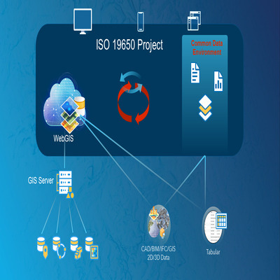
ISO 19650 part-1 and part-2 present attractive solutions for managing information on project-based work that include BIM data. The usage of BIM data in combination with GIS data is important for large-scale work such as infrastructure projects. The spatial context enables deeper insight for better decision-making, communication, and understanding. Furthermore, having GIS/BIM data shared on the web enables easier sharing and exchanging of data. ISO 19650-1:2018 contains the concept of a Common Data Environment (CDE), and defines it as “agreed source of information for any given project or asset, for collecting, managing, and disseminating each information container through a managed process. A CDE workflow describes the process to be used and a CDE solution might provide the technology to support those processes”. The definition of a CDE covers both the process for collecting, managing and disseminating information and the technological solutions that support this process. This thesis studies what information management standards are in ISO 19650-1:2018 and ISO 19650-2:2018. Furthermore, it investigates the possibility of implementing a common data environment and applying these standards for projects based on WebGIS platforms and Webservices as an exchange data format.

Supervisors: Stelios Vitalis + Francesca Noardo
with esri Nederland (Niels van der Vaart)

Mihai-Alexandru Erbașu
Improving the content of vario-scale maps

The main goal of this research is to improve the automated generalization process for vario-scale maps at non-fixed levels of detail (stored with the tGAP data structure). Traditionally, the content for vario-scale maps has been created using a ‘one fits all’ approach equal for all scales. Due to this fact, currently available vario-scale maps are often not well-tuned, and thus can generate an undesired result. This graduation project will look at the various pieces of puzzle which constitute a good and adaptive vario-scale map, such as the aggregation of non-direct neighbors, how the generalization operators are orchestrated, line simplification analysis and how linear features are treated, among others, and will try to showcase how these fit together in the overall vario-scale algorithm. A thorough research on these elements shall be conducted, and presented alongside a demo web application, showcasing the analysis.

Supervisors: Martijn Meijers + Peter van Oosterom

Denis Giannelli
Performing solar analysis in buildings of favelas in Sao Paulo to estimate PV potential

In the Global South, large urban spaces resulted in the duality ‘formal’ and ‘informal’ cities. It’s the case of Sao Paulo, a 22M ppl. metropolis and a financial hub in Latin America. Albeit a vast literature addresses the social-spatial segregation emerging from this dual built environment, the scarcity of spatial datasets regarding informal settlements also enforces a geo-information segregation, resulting in a terra incognita. This is exemplar in favelas, defined as precarious, spontaneous and unorganised land occupation built on third-party property, most of which lack cadastral data. As favelas are often not mapped, assessing urban phenomena becomes a technical challenge for several application domains, e.g. the energy one. Recent public initiatives in Brazil estimate solar irradiation and photovoltaic potential for buildings at city scale, but favelas are intentionally excluded from the resulting web-based solar maps. Technicians believe that the absence of a spatial pattern in favelas calls for investigation on how to refine a roof mapping methodology. The research questions thus become 1) How far is it possible to perform solar analysis in buildings of favelas in Sao Paulo with the goal of estimating PV potential? 2) What are the min. required geodata to map buildings (roofs) in a favela, and can a specific methodology be set up? 3) What are the requirements, level of applicability and type of results (e.g. accuracy) delivered by different existing irradiation models?

Supervisors: Giorgio Agugiaro + Camilo Alexander León Sánchez

Robin Hurkmans
Modelling solar irradiation for buildings in the 3D BAG vector dataset

Solar energy is an important type of renewable energy. Building roofs are very suitable to install solar panels used for generating solar energy. However, not every roof is as suitable as another roof. Therefore, to optimize where solar panels should be placed, and to estimate the solar potential of a given area, one can model solar irradiation by taking into account all the factors influencing the solar potential of a building. Currently, most of the methods are using as input raster data, such as digital elevation models (DEMs). However, more and more 3D vector models of urban regions are available, for instance the 3D BAG. Efficient algorithms using those 3D vector data as input are not widely available and implemented yet. This thesis will focus on developing a methodology, and implementing it, that takes (a part of) the 3D BAG dataset as input to calculate the solar irradiation of every building included in the dataset. To perform this, at least the following factors will be considered:

  • The position of the sun for varying time at the respective building position;
  • Slope and aspect of the faces of a building;
  • Obstructions by surrounding buildings (and potentially for trees, if time allows it). Methods considering voxels and ray tracing are likely to be suitable for modelling solar irradiation for vector data. It is essential that the newly developed method, making use of existing methods and software packages, has a relatively high performance for large datasets.
Supervisors: Hugo Ledoux + Stelios Vitalis

Rohit Jyotish Kailashkumar Ramlakhan
Modelling 3D underground objects in 3D Land Administration Systems

The majority of existing Land Administration Systems (LASs) around the world are based on 2D systems where a 2D parcel/spatial unit is the key-entity of property registration. Those systems are supported by processes that are designed for 2D parcel representation in digital format and are often still implemented using paper-based records. In order to cope with the societal trends, such as urbanisation, societal disparities, and the digital transformation, those systems need re-engineering to extend into 3D.

The use of 3D objects in LASs occurs when the Rights, Restrictions and Responsibilities (RRRs) are linked to the volume of a 2D parcel. 2D parcels do not adequately support the use of 3D objects below and above the surface. It is not always clear who owns the objects below the surface. How the objects above and below the surface are connected is often not known. Using a 3D LAS can make registering and visualisation of RRRs less complicated and will lead to several benefits such as improving and assisting in the decision making in urban development.

There is however no standardised workflow on how to collect, process, store, visualise, disseminate and query 3D underground data in a 3D LAS and model the relations between underground and above-ground objects.

The objective of this research is defined by the research question formed below:

How can 3D underground objects be modelled in a 3D Land Administration System and connected to above-ground objects?

Supervisors: Eftychia Kalogianni + Peter van Oosterom

Laurens Nico van Rijssel
Optimizing a TIN for accurate and efficient noise modelling

It is generally assumed that higher level of detail results in higher accuracy of the output. However, it comes at a cost, more detail yields larger files and growing computational times. When modelling noise, the influence of terrain details on the noise propagation depends on the local shape and characteristics. Therefore the output accuracy does not only depend on the general level of detail, but also on the local detail in shapes that influence the noise propagation most.

The aim of this research is to identify the influence of landscape characteristics on noise propagation and develop a product to automatically construct a TIN holding semantic information and buildings information for noise modelling purposes.

Supervisors: Balázs Dukai + Jantien Stoter
with RIVM