Theses starting September 2020

Charalampos Chatzidiakos
How should roads be modelled in 3D City Models?

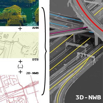
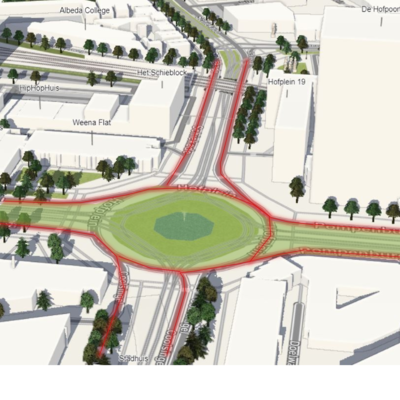
Nowadays, 3D semantic city models are more and more used for the analysis of large urban areas. Until now, the focus has mostly been on models of buildings that have become very common. Nonetheless, many cases that could benefit from the detailed geometrical and semantic representation of road networks as well (Beil, Christof & Kolbe, Thomas, 2017). Nevertheless, the representation of roads in 3D city models might have potential drawbacks. The complexity related to the geometries of the model will increase while the file will become more complex as well. The main problem is that since roads in 3D city models is a fairly new development there are a few guidelines regarding modelling. The are many undefined concepts. With respect to that, this Thesis aims to answer: What is the most efficient way to model road networks and intersections in 3D semantic city models? And are the benefits of doing this overcome the potential downsides? During this thesis, different ideas for modelling roads will be analyzed. Areal and linear representations of existing data of roads will be used. Making use of python programming language, different approaches on how both these representations will be stored in a single CityJSON file for a road city object will be explored. Modelling intersections of roads is expected to be the most challenging part regarding modelling (Freek Boersma 2019). The linkage of linear (MultiLineStrings) and areal (Multisurfaces) data by one to one mapping will be tested.

Supervisors: Anna Labetski + Ken Arroyo Ohori

Zhaiyu Chen
Polygonal Mesh Reconstruction from Point Clouds with Deep Implicit Fields

Polygonal meshes provide an efficient representation for 3D shapes with sparse sets of parameters. With the advent of deep neural networks, learning-based approaches for 3D reconstruction have gained popularity. However, end-to-end reconstruction from point clouds to polygonal meshes is still non-trivial. Existing methods either fail to incorporate high-level shape information, or struggle to comply with certain geometric constraints.

We propose a novel framework for reconstructing compact, watertight, polygonal meshes from point clouds by incorporating the implicitly represented function space with explicitly encoded geometry. Initial results show that our method is able to reconstruct meshes with high geometric fidelity and error-free topology (demo). We hope our work, as of future iterations, can bridge the ubiquitous 3D deep learning solutions with more geometric constraints that are hugely neglected nowadays.

Supervisors: Liangliang Nan + Seyran Khademi

Constantijn Dinklo
Visualizing Massive Computational Fluid Dynamic Simulation Output Data Efficiently Using Game Engines

Currently, visualizing large Computation Fluid Dynamic (CFD) datasets is a rather difficult task to accomplish. This is because CFD outputs produce exceptionally large data files. Programs that are used to visualize data are generally not equipped to deal with these large datasets. Paraview is one of these possible programs, however, it can be slow to respond and can crash on multiple occasions due to RAM constraints. On the other hand, it does implement features like slicing and viewing the data at different time periods, which are both desired in a possible solution. Game engines can run 4K graphics at 60fps by optimizing their graphics rendering. I will be looking into these engines to see what help they can provide in increasing performance. However, it should be noted that these engines do not implement the above-mentioned features by default. Currently, splitting the datafiles into smaller provides one option of visualizing the data. However, this removes the option of viewing the entire simulation in one go. Some possible tactics that could be applied to increase the performance are loading in individual data types and reducing the number of input data points based on distance from the model. The outcome of this project should determine whether using games engines is a feasible option to display CFD simulation output datasets.

Supervisors: Clara García-Sánchez + Hugo Ledoux

Truc Quynh Doan
Test and extension of a GIS-supported design tool for new urban development areas

The emergence of spatial data and GIS-supported tools has induced more inclusive spatial planning approaches. While urban settings are efficiently assessed through spatial analyses in the pre-design stage, 3D city modelling and web technologies help to visualize and disseminate development scenarios in the post-design stage. The intermediate stage regarding design solution and evaluation, however, hasn’t widely supported. Hence, the first version of a GIS-supported design tool has developed in a previous study to assist the realization of the 3D model of development scenarios. Site analysis was conducted on the City of today to generate KPIs for the following design stage. The design solutions are then integrated back into a 3D city model and are disseminated via web platforms.

This thesis aims to test, critically review, and propose extensions and improvements for the product. The focus will be on the expansion of input KPIs, the output parameters, and the impacts of the designs on the urban settings. To generate KPIs, a data-driven approach that considers spatial and non-spatial, volumetric and non-volumetric data will be employed. Regarding output parameters and impact estimation, the scenarios’ 3D model will be incorporated into the current 3D model to perform spatial analyses based on a set of criteria. These approaches thus will contribute to the further integration of 3D city models into the planning process and explore its possibilities in assisting urban practices.

Supervisors: Giorgio Agugiaro + Roberto Cavallo

Nadine Hobeika
Interaction between wind flows and beach housing to promote dune formation

In 2017, the ‘Kuspact’, a Dutch national agreement, was signed to develop the Dutch coast without damaging its ecosystem nor its aesthetics. Consequently, the formation and protection of coastal dunes have become a focal point for research and development. For this reason, this Master thesis aims to investigate the impact of certain coastal house configurations on wind turbulence for the purpose of either heightening or widening the dunes, or even both. Computational fluid dynamics (CFD) will be used to simulate wind around the configurations and the dunes. The beach-dune profile and four initial configurations were provided by a landscape architecture PhD student from the University of Twente. Based on the initial simulations, further configurations and parameters will be tested to optimise the results. To simulate the wind turbulence, the Reynolds averaged Navier-Stokes (RANS) model will be used. More specifically, simulations will be carried out using the Re-Normalisation Group k-epsilon (RNG k-epsilon) model because it has so far been established as the most suited to model the effects of wind turbulence in the built environment. After running the simulations in OpenFOAM software, relevant fields such as pressure and velocity will be analysed to filter configurations and conclude with the best choice for the Dutch coast.

Supervisors: Clara García-Sánchez + Ivan Pađen

Maarten de Jong
One TIN for all AHN3 points with Streaming Delaunay Triangulation

The goal of this thesis project is to explore how the streaming paradigm can be used to create a seamless TIN of all AHN3 points in the Netherlands (~800B). The advantage of using a streaming Delaunay triangulation is that it circumvents having to load all the points into memory, which is an impossible task at this scale. However, a disadvantage is that this method requires an understanding of when points are no longer necessary for the triangulation and can be stored to disk and unloaded from memory. Challenges lie in determining how the point ordering of the AHN3 tiles will affect the efficiency of the algorithm, as well as ensuring that artefacts do not occur around tile borders. Furthermore, an assessment will be made of whether it is possible to simplify the triangulation at a local level. This consists of determining a (basic) methodology to reduce the number of triangles. This will reduce the overall size of the resulting triangulation, making easier to work with in subsequent research. The desired final result of this thesis project is to have a process in place that is capable of handling a large number (> 50) of AHN3 tiles and Delaunay triangulating them, while performing some simplification.

Supervisors: Hugo Ledoux + Ravi Peters

Kristof Kenesei
Converting the national road network (NWB) from 2D into 3D

The Dutch Nationaal Wegenbestand (NWB) open data road model is effectively a graph representation of the Dutch road network. It is primarily used for modelling purposes, such as that of noise propagation and traffic flow – often to serve as the basis for regulatory compliance evaluation. Due to changes in Dutch noise modelling policy, the data set now needs to be transposed into 3D. The responsible government agency, Rijkswaterstaat, is therefore seeking a solution that can automatically enrich the road model with elevation estimates. This includes roads in complex multi-level and urban settings. Our research aims to find out whether a combination of Dutch open geospatial data (such as AHN and DTB) and the maintainer’s civil engineering data can be used to realise this task in a way that the output fulfils the prescribed accuracy requirements. To do this, we will assess which data sets can contribute to this task, and in what way. Attention will be devoted to establishing how (or even if) we can track the propagation of the uncertainty descriptors of the source data through the considered workflows. In terms of the workflow itself, we are curious to see whether building a shared 2.5D model from the input sources could handle complex 3D layouts, such as overpasses. To find out, we intend to create prototype implementations using tools that are common in the Geomatics discipline.

Supervisors: Ravi Peters + Jantien Stoter

Xiaoai Li
CityREST: CityJSON in a database + RESTful access

OGC recently released the WFS 3.0 standard called “OGC API – Features: Part 1 – Core”. It is a more open and more web-oriented RESTful API. CityJSON as a JSON-based exchange format of 3D city models is less verbose and more web-friendly than CityGML and can be used in a broad range of applications. Therefore, the efficient dissemination and easy access of CityJSON datasets can be very valuable.

The OGC APIs focus on 2D datasets that lack usability for 3D research and applications. The different CRSs in CityJSON datasets can also be problematic. Besides, there exists no specific database or schema for the storage of CityJSON datasets on the server which limits the dissemination.

The research questions are conducted with this in mind.

  • How to develop a RESTful API for access to geospatial feature resources in CityJSON and to realize the fast retrieval of part city objects?
  • How to properly store CityJSON in a database to support a RESTful access?

The schema of CityJSON is mapped to an entity-relationship model for the storage on a database. Restful API is developed for access and data filtering (bbox, attributes etc.). Then benchmarking is used for testing the performance of the RESTful API.

Supervisors: Stelios Vitalis + Hugo Ledoux

Yustisi Ardhitasari Lumban Gaol
Machine Learning Approach for Satellite-Derived Bathymetry with Minimal In-situ Data

Shallow water depth information is essential for coastal management and research. Satellite-Derived Bathymetry (SDB) is a way to model water depth in shallow water areas. It can be used to fill data gaps that occur with the conventional survey method based on echo sounding. It is also a low-cost technique since remote sensing images are used instead of field surveys. The basic principle of SDB is to produce a continuous water depth field by finding the correlation between bottom reflectance from satellite images and in-situ depth acquired from conventional surveys. A major limitation of the SDB model is that it requires in-situ data for calibration, but shallow water in-situ data is not available for many areas. Most studies achieved a precise model by applying the model within in-situ coverage. However, it becomes challenging when the goal is to generate an SDB model by minimizing the amount of in-situ data and using the calibration model outside the input coverage. This research aims to investigate the possibility of machine learning to derive an SDB model with limited in-situ data. A machine learning method will be developed to extract depth in the shallow water area. The method will focus on minimizing the in-situ data needed for training and observing the resulting quality. The quality of the model will be assessed based on evaluation metrics, i.e. root mean square error and total vertical uncertainty.

Supervisors: Ken Arroyo Ohori + Ravi Peters

Nur An Nisa Milyana
Designing user experience (UX) to trigger participation in spatial planning

The modern-day spatial planning requires sensitivity to seek a balance between how to develop existing living environment while maintaining a citizen’s perspective. Therefore, cities are required to re-define their public participation strategies by adoption modern tools that could increase the trust and satisfaction of citizens regarding planning products. This challenge has made geographic information system (GIS) technologies invaluable to the experts for enhancing the place-making process by transforming spatial data into actionable insights for citizens. These days, web-based GIS are often used to foster the citizen participation process. However, involving users in GIS within the planning decision system has increased the complexity of the deliverables of spatial information. Moreover, the implementation of GIS with a central role in delivering spatial plans should be in more user-friendly way. At this core, User Experience (UX) could help the spatial planning experts to make this spatial information to become more ”humane”. User Experience (UX) can be the suitable approach for engaging users with spatial planning deliverables. This thesis project will investigate how can user experience be applied to trigger active participation in spatial planning. The research will develop an UX mockup design and find the possibility to be applied as web-based GIS prototype. The focus of the study will be based on spatial planning in Indonesia.

Supervisors: Hendrik Ploeger + Bastiaan van Loenen

Camille Morlighem
Automatic reconstruction of historical 3D city models

This thesis is about automatically reconstructing 3D buildings from historical maps. Current 3D city models are nowadays well-known and used for many applications, but historical 3D city models remain difficult to generate as they rely on various historical sources as historical maps and photographs. Yet historical 3D city models are valuable for the historical heritage as they ease the restoration of cultural sites and may provide worldwide access to these sites, among other applications. Some research has been conducted in this area, but the methods proposed to build historical 3D city models stay essentially manual. Therefore, the objective of this thesis is to automate as much as possible the whole process from the vectorization of the historical maps to the generation of the historical 3D city models. The first steps to implement are the georeferencing of the historical maps, followed by the extraction of the building footprints using machine learning or deep learning algorithms. A crude 3D city model will first be generated from the building footprints using procedural modelling. Building height could be extracted from historical photographs or defined by superimposing the current AHN3 over the building footprints. This crude 3D city model will then be further refined by including information from cadastral data. With this method, several historical 3D city models will be generated for different epochs, which will allow representing the evolution of a city.

Supervisors: Hugo Ledoux + Anna Labetski

Manos Papageorgiou
Point cloud classification with supervised deep learning algorithms for automatic reconstruction of LoD2 3D city models

The goal of my thesis is to assist in the automatic reconstruction of LoD2 3D city models from lidar point clouds with a method that requires a classified point cloud and building footprints. Specifically, I will be investigating the preprocessing steps of this method where a point cloud is classified into ground, building and other points and further segmented into individual building instances from which the building footprints are extracted. This data can be then used as input to an already in development experimental software to produce an LoD2 3D city model. Since accurate building footprints and classified point clouds are not always available at our disposal, this research is meant to help in situations where the available datasets have different accuracies and inconsistencies between them by reducing the required data to produce an LoD2 3D city model to just an unclassified point cloud. More specifically, this thesis will focus on the classification of lidar point clouds using deep learning and the research question it will attempt to answer is how well existing neural networks will perform if we train them with the AHN3 dataset. To answer this question, multiple tests will be conducted with various supervised deep learning algorithms and datasets using python coding and open source code from Github while software like QGIS, FME, Blender and Meshlab will be used for data preparation and visualization.

Supervisors: Ravi Peters + Weixiao Gao

Ellie Roy
Inferring the number of floors of all buildings in the Netherlands

In the Netherlands, information on buildings is provided as open-data via the “Basisregistratie Adressen en Gebouwen”, or BAG for short. Part of this dataset consists of 2D polygons representing the footprints of all buildings. Each footprint is associated with a number of attributes, such as the construction date and current use. However, the number of floors within each building is currently not included. This would be a valuable additional attribute for many applications. For example, flood response plans require this information to determine the number of inhabitable storeys remaining given a breach of flood defences. In addition, this information is required for energy performance estimations. Therefore, this thesis focuses on the development of an automatic method to infer the number of floors of all buildings in the Netherlands. This method will firstly consider the residential building stock, before potentially also including other building typologies. Previous efforts have focused on dividing the measured height of a building by an average floor-to-ceiling height. However, this over-simplification limits the accuracy of the results. The improved method will focus on using building attributes, such as the roof shape and construction year, to provide a more realistic estimate of the number of floors. The method will most likely use machine learning techniques, based on training data collected from multiple municipalities.

Supervisors: Hugo Ledoux + Giorgio Agugiaro
with Deltares (Maarten Pronk)

Mels Smit
Detecting glass through LiDAR Point Clouds

During my master thesis I will be investigating options to detect glass in LiDAR Point Clouds. This is a non-trivial assignment as LiDAR is a light based scanning technique. As glass is both transparent and reflective, light has trouble getting a good reading of this material as it can be absorbed, pass through it or be reflected by it, with only very little of the reflected light being sent back to the scanner. Because of this, points tend to show up at places where nothing should be if glass is present in the scene. This then provides false information in Point Clouds showing or not showing obstacles where they shouldn’t or should be. To do this research is done into different types of Point Clouds to see which properties can be used to deduce the placement of glass in the scenes. Should the initial approach of only using the available data in a Point Cloud not prove to be accurate enough, then combining other sensor data with the LiDAR scans can also prove promising. Examples of this could be Thermal Infrared cameras to detect heat changes where glass is present or Sonar pulses that are able to see glass as it reflects sound just fine. The found results of these extra sensors could then be used to detect glass as walls that these methods detect where the LiDAR scan does not, show the presence of a transparent or reflective material such as glass or mirrors. By fusing these results with the Point Cloud glass can then be placed inside as well enhancing the end result.

Supervisors: Edward Verbree + Martijn Meijers
with CGI (Robert Voûte)

Anna Vera Stevers
Modelling wind around beach housing for dune formation

Along the Dutch coast, the dunes are the first line of defence against the sea. To let the dunes grow along with the rising sea level, we need sediment transport by wind. However, the growing number of beach housing on Dutch beaches effect the wind, and therefore the sedimentation. The configurations of these buildings can influence the amount of sediment transport along the beaches. It is interesting therefore to explore the possibilities of configurations that could increase sediment transport rather than limit this. Increased sedimentation can promote dune formation and therefore aid in flood protection.

The objective of this thesis is to model different types of beach house configurations and the effects they have on the sediment flow considering multiple wind conditions. We aim to find if some types of configurations can support the sediment transport. As a case study this thesis will focus on the beaches of Noordwijk, the Netherlands. The different configurations of beach housing and the effects of the wind can be simulated by creating CFD models using OpenFOAM. The CFD models show the direction and speed of wind around a 3D city model. Using these simulations we can determine which configurations have the highest potential to either heighten, or widen to dunes.

This thesis, together with Nadine Hobeika’s, will be part of the ShoreScape project, a research conducted by TU Delft and UTwente. The results from our work can be used in real life models on beaches in 2021.

Supervisors: Clara Garcia Sanchez + Giorgio Agugiaro
with ShoreScape (Janneke van Bergen)

Jialun Wu
A CityJSON extension to store city information towards the automation of building permit

Automated analysis and management of 3D city data will promote the development of the city, especially in large cities like Rotterdam. Therefore, this study focuses on the digitization and automation of the building permission checks which support government officials in real situations. This will follow the ambitions/specification of European Network for Digital Building Permits (reference: EUnet4DBP) by implementing simple and machine-readable rules and requirements which means we formalize and store the information related to the regulation in our 3D city model following a formal data structure (the CityGML and CityJSON ADE mechanism give inspiration for this part). Besides, it will ensure interoperability which allows officials to visualize and check the buildings follow the open standards. The key point of this research is to realize the interpretation and formalization of laws and regulations, they are then translated into algorithms for automated computation and analysis. The research will develop an extension of CityJSON to extend the existing data model since CityJSON has better interoperability than CityGML. We then utilize it in building permission check applications. It will store, evaluate, and verify the final results. This research will be carried out with a specific case study, by selecting a small area of the research area (Rotterdam) and specific laws and regulations to conduct the research, and then extend it to the realization of more laws and regulations.

Supervisors: Francesca Noardo + Ken Arroyo Ohori